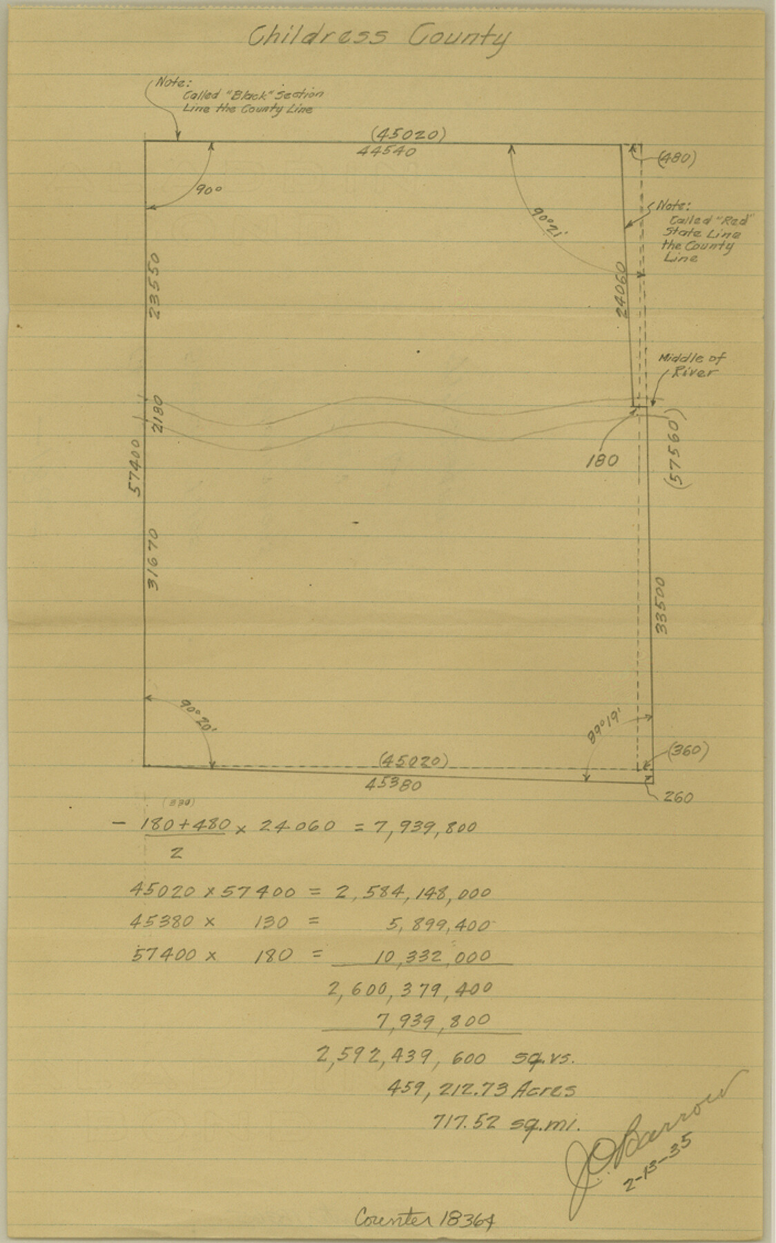
Childress County Sketch File 18a
[Calculations of the area of Childress County]
-
Map/Doc
18364
-
Collection
General Map Collection
-
Object Dates
1935/2/13 (File Date)
1935/2/13 (Creation Date)
-
People and Organizations
J.O. Barrow (Surveyor/Engineer)
-
Counties
Childress
-
Subjects
Surveying Sketch File
-
Height x Width
11.3 x 7.1 inches
28.7 x 18.0 cm
-
Medium
paper, manuscript
Part of: General Map Collection
Jefferson County Rolled Sketch 28

Print $20.00
- Digital $50.00
Jefferson County Rolled Sketch 28
1948
Size 22.4 x 32.9 inches
Map/Doc 6391
Duval County Sketch File 34

Print $20.00
- Digital $50.00
Duval County Sketch File 34
Size 28.4 x 36.9 inches
Map/Doc 11391
Tom Green County Sketch File 37

Print $2.00
- Digital $50.00
Tom Green County Sketch File 37
Size 9.4 x 8.5 inches
Map/Doc 38195
Freestone County Boundary File 30

Print $8.00
- Digital $50.00
Freestone County Boundary File 30
Size 10.7 x 8.3 inches
Map/Doc 53588
Flight Mission No. BRA-7M, Frame 150, Jefferson County

Print $20.00
- Digital $50.00
Flight Mission No. BRA-7M, Frame 150, Jefferson County
1953
Size 18.7 x 22.4 inches
Map/Doc 85544
Johnson County Working Sketch 24

Print $20.00
- Digital $50.00
Johnson County Working Sketch 24
1996
Size 47.5 x 34.5 inches
Map/Doc 66637
Kleberg County Aerial Photograph Index Sheet 5

Print $20.00
- Digital $50.00
Kleberg County Aerial Photograph Index Sheet 5
1956
Size 19.5 x 23.5 inches
Map/Doc 83722
Newton County Working Sketch 17

Print $20.00
- Digital $50.00
Newton County Working Sketch 17
1950
Size 15.1 x 23.0 inches
Map/Doc 71263
Randall County Sketch File 4

Print $20.00
- Digital $50.00
Randall County Sketch File 4
1903
Size 35.6 x 13.4 inches
Map/Doc 12207
Newton County Sketch File 4

Print $22.00
- Digital $50.00
Newton County Sketch File 4
1876
Size 8.0 x 12.8 inches
Map/Doc 32360
Gillespie County Sketch File 16

Print $20.00
- Digital $50.00
Gillespie County Sketch File 16
1951
Size 18.2 x 17.9 inches
Map/Doc 11557
Harris County Working Sketch 95

Print $20.00
- Digital $50.00
Harris County Working Sketch 95
1978
Size 26.6 x 44.1 inches
Map/Doc 65987
You may also like

Leon County Working Sketch 28

Print $20.00
- Digital $50.00
Leon County Working Sketch 28
1971
Size 25.0 x 30.1 inches
Map/Doc 70427
Map of Newton County

Print $40.00
- Digital $50.00
Map of Newton County
1894
Size 74.9 x 27.7 inches
Map/Doc 16778
Oldham County

Print $40.00
- Digital $50.00
Oldham County
1925
Size 41.5 x 53.2 inches
Map/Doc 95604
Plan of the cities of Denver, Auraria and Highland, Jefferson Terr.

Print $20.00
- Digital $50.00
Plan of the cities of Denver, Auraria and Highland, Jefferson Terr.
1859
Size 23.7 x 29.8 inches
Map/Doc 94053
Map of Jefferson County

Print $20.00
- Digital $50.00
Map of Jefferson County
1896
Size 26.7 x 23.2 inches
Map/Doc 66883
Flight Mission No. CGI-1N, Frame 140, Cameron County

Print $20.00
- Digital $50.00
Flight Mission No. CGI-1N, Frame 140, Cameron County
1955
Size 18.7 x 22.3 inches
Map/Doc 84496
Erath County Rolled Sketch 4

Print $20.00
- Digital $50.00
Erath County Rolled Sketch 4
Size 29.1 x 40.9 inches
Map/Doc 5866
Brewster County Sketch File N-10

Print $14.00
- Digital $50.00
Brewster County Sketch File N-10
1922
Size 11.2 x 8.7 inches
Map/Doc 15616
Val Verde County Rolled Sketch 42

Print $20.00
- Digital $50.00
Val Verde County Rolled Sketch 42
1919
Size 17.3 x 21.9 inches
Map/Doc 8116
Map of Hardin County

Print $20.00
- Digital $50.00
Map of Hardin County
1902
Size 43.1 x 44.2 inches
Map/Doc 66854
Kimble County Working Sketch 70

Print $20.00
- Digital $50.00
Kimble County Working Sketch 70
1965
Size 41.2 x 25.3 inches
Map/Doc 70138