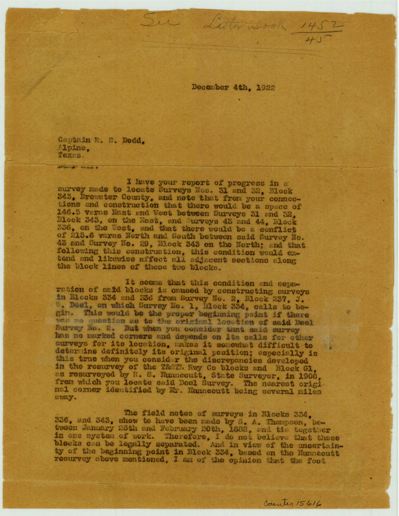
Brewster County Sketch File N-10
[Report of progress in a survey made to locate the northwest corner of section 32 and southwest corner of section 31 in Block 343]
- 
                          Map/Doc
15616
 - 
                            Collection
General Map Collection
 - 
                            Object Dates
1922/12/4 (Correspondence Date)
1922/11/21 (Creation Date)
1922/11/24 (File Date)
 - 
                            People and Organizations
R.S. Dod (Surveyor/Engineer)
 - 
                            Counties
Brewster
 - 
                            Subjects
Surveying Sketch File
 - 
                            Height x Width
11.2 x 8.7 inches
28.4 x 22.1 cm
 - 
                            Medium
paper, print
 - 
                            Features
Maxon Spring
Persimmon Gap
San Francisco [Creek]
Makon Spring
 
Part of: General Map Collection
            Andrews County Rolled Sketch 22


                                            Print $20.00                    
                                             -                         Digital $50.00                                    
                Andrews County Rolled Sketch 22
1946
Size 26.4 x 24.0 inches
                                Map/Doc 77170
            
            Duval County Sketch File 45a


                                            Print $9.00                    
                                             -                         Digital $50.00                                    
                Duval County Sketch File 45a
Size 14.5 x 9.0 inches
                                Map/Doc 21396
            
            Harris County Aerial Photograph Index Sheet 10


                                            Print $20.00                    
                                             -                         Digital $50.00                                    
                Harris County Aerial Photograph Index Sheet 10
1953
Size 22.1 x 16.9 inches
                                Map/Doc 83704
            
            Montague County Sketch File 9


                                            Print $18.00                    
                                             -                         Digital $50.00                                    
                Montague County Sketch File 9
1872
Size 12.6 x 11.7 inches
                                Map/Doc 31724
            
            Rains County Working Sketch 6


                                            Print $20.00                    
                                             -                         Digital $50.00                                    
                Rains County Working Sketch 6
1958
Size 26.4 x 42.3 inches
                                Map/Doc 71832
            
            Flight Mission No. DQO-1K, Frame 155, Galveston County


                                            Print $20.00                    
                                             -                         Digital $50.00                                    
                Flight Mission No. DQO-1K, Frame 155, Galveston County
1952
Size 18.9 x 22.5 inches
                                Map/Doc 85008
            
            Stephens County Working Sketch 1


                                            Print $20.00                    
                                             -                         Digital $50.00                                    
                Stephens County Working Sketch 1
Size 13.5 x 16.1 inches
                                Map/Doc 63944
            
            Blanco County Sketch File 36


                                            Print $8.00                    
                                             -                         Digital $50.00                                    
                Blanco County Sketch File 36
1889
Size 11.2 x 8.8 inches
                                Map/Doc 14642
            
            Newton County Sketch File 8


                                            Print $4.00                    
                                             -                         Digital $50.00                                    
                Newton County Sketch File 8
Size 11.0 x 9.0 inches
                                Map/Doc 32376
            
            Hardeman County


                                            Print $20.00                    
                                             -                         Digital $50.00                                    
                Hardeman County
1935
Size 44.4 x 41.4 inches
                                Map/Doc 73170
            
            Van Zandt County Working Sketch 20


                                            Print $20.00                    
                                             -                         Digital $50.00                                    
                Van Zandt County Working Sketch 20
1992
Size 30.4 x 34.7 inches
                                Map/Doc 72270
            
            Yoakum County Sketch File 17


                                            Print $48.00                    
                                             -                         Digital $50.00                                    
                Yoakum County Sketch File 17
1898
Size 14.5 x 8.9 inches
                                Map/Doc 40796
            You may also like
            Jackson County Sketch File 30


                                            Print $52.00                    
                                             -                         Digital $50.00                                    
                Jackson County Sketch File 30
1944
Size 14.2 x 8.5 inches
                                Map/Doc 27730
            
            General Highway Map, Collingsworth County, Texas


                                            Print $20.00                    
                                    
                General Highway Map, Collingsworth County, Texas
1961
Size 18.1 x 24.6 inches
                                Map/Doc 79415
            
            Eastland County Working Sketch 30


                                            Print $20.00                    
                                             -                         Digital $50.00                                    
                Eastland County Working Sketch 30
1954
Size 20.2 x 24.0 inches
                                Map/Doc 68811
            
            Shelby County Working Sketch 18


                                            Print $20.00                    
                                             -                         Digital $50.00                                    
                Shelby County Working Sketch 18
1957
Size 20.7 x 27.4 inches
                                Map/Doc 63871
            
            Texas map showing principal forts


                                            Print $20.00                    
                                             -                         Digital $50.00                                    
                Texas map showing principal forts
1852
Size 34.7 x 25.1 inches
                                Map/Doc 2125
            
            [Northwest Garza County around John Walker and Thomas Hughes surveys]


                                            Print $20.00                    
                                             -                         Digital $50.00                                    
                [Northwest Garza County around John Walker and Thomas Hughes surveys]
1913
Size 27.5 x 14.3 inches
                                Map/Doc 90848
            
            Dawson County Sketch File 9


                                            Print $4.00                    
                                             -                         Digital $50.00                                    
                Dawson County Sketch File 9
1925
Size 11.3 x 8.7 inches
                                Map/Doc 20542
            
            Flight Mission No. DCL-7C, Frame 59, Kenedy County


                                            Print $20.00                    
                                             -                         Digital $50.00                                    
                Flight Mission No. DCL-7C, Frame 59, Kenedy County
1943
Size 15.4 x 15.2 inches
                                Map/Doc 86047
            
            Coast Chart No. 210 - Aransas Pass and Corpus Christi Bay with the coast to latitude 27° 12', Texas


                                            Print $20.00                    
                                             -                         Digital $50.00                                    
                Coast Chart No. 210 - Aransas Pass and Corpus Christi Bay with the coast to latitude 27° 12', Texas
1907
Size 18.4 x 24.1 inches
                                Map/Doc 73453
            
            [Sketch Showing Surveys on Pease River in Hardeman County, Texas]


                                            Print $20.00                    
                                             -                         Digital $50.00                                    
                [Sketch Showing Surveys on Pease River in Hardeman County, Texas]
Size 19.2 x 37.5 inches
                                Map/Doc 10760
            
            Bailey County Sketch File 13


                                            Print $40.00                    
                                             -                         Digital $50.00                                    
                Bailey County Sketch File 13
1912
Size 19.2 x 20.6 inches
                                Map/Doc 10888
            
            Sketch of the Designation of Route of the Aransas Channel Harbor & Dock Company's Deep Water Channel


                                            Print $3.00                    
                                             -                         Digital $50.00                                    
                Sketch of the Designation of Route of the Aransas Channel Harbor & Dock Company's Deep Water Channel
Size 13.2 x 10.0 inches
                                Map/Doc 4495