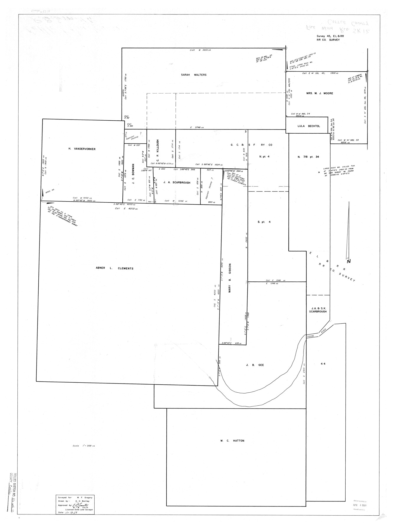
Cottle County Rolled Sketch 12
[Sketch of Abner L. Clements survey and surrounding surveys]
-
Map/Doc
5570
-
Collection
General Map Collection
-
Object Dates
1959/11/19 (Creation Date)
1963/6/1 (File Date)
-
People and Organizations
R.B. Smith (Surveyor/Engineer)
O.H. Bartley (Draftsman)
-
Counties
Cottle Hardeman
-
Subjects
Surveying Rolled Sketch
-
Height x Width
41.1 x 30.9 inches
104.4 x 78.5 cm
-
Scale
1" = 300 varas
Part of: General Map Collection
Walker County Working Sketch 1

Print $20.00
- Digital $50.00
Walker County Working Sketch 1
1912
Size 20.1 x 18.4 inches
Map/Doc 72281
Map of Fannin County

Print $40.00
- Digital $50.00
Map of Fannin County
1841
Size 50.4 x 46.8 inches
Map/Doc 7821
Flight Mission No. CRC-2R, Frame 122, Chambers County

Print $20.00
- Digital $50.00
Flight Mission No. CRC-2R, Frame 122, Chambers County
1956
Size 18.9 x 22.5 inches
Map/Doc 84746
Floyd County Sketch File 21

Print $20.00
- Digital $50.00
Floyd County Sketch File 21
1914
Size 30.0 x 23.2 inches
Map/Doc 11486
Potter County

Print $20.00
- Digital $50.00
Potter County
1909
Size 45.3 x 40.6 inches
Map/Doc 16790
Flight Mission No. BRA-8M, Frame 147, Jefferson County

Print $20.00
- Digital $50.00
Flight Mission No. BRA-8M, Frame 147, Jefferson County
1953
Size 16.0 x 15.9 inches
Map/Doc 85639
Kimble County Working Sketch 74

Print $20.00
- Digital $50.00
Kimble County Working Sketch 74
1966
Size 43.1 x 34.2 inches
Map/Doc 70142
Borden County Working Sketch 8

Print $20.00
- Digital $50.00
Borden County Working Sketch 8
1951
Size 24.7 x 34.4 inches
Map/Doc 67468
[Sketch for Mineral Application 20124, North Fork of Red River]
![2828, [Sketch for Mineral Application 20124, North Fork of Red River], General Map Collection](https://historictexasmaps.com/wmedia_w700/maps/2828.tif.jpg)
Print $20.00
- Digital $50.00
[Sketch for Mineral Application 20124, North Fork of Red River]
1943
Size 18.8 x 25.8 inches
Map/Doc 2828
[Surveys in the Bexar District in the vicinity of Salado and Saltillo Creeks]
![234, [Surveys in the Bexar District in the vicinity of Salado and Saltillo Creeks], General Map Collection](https://historictexasmaps.com/wmedia_w700/maps/234.tif.jpg)
Print $2.00
- Digital $50.00
[Surveys in the Bexar District in the vicinity of Salado and Saltillo Creeks]
1847
Size 10.3 x 9.1 inches
Map/Doc 234
Lampasas County Working Sketch 12

Print $20.00
- Digital $50.00
Lampasas County Working Sketch 12
1969
Size 32.9 x 31.4 inches
Map/Doc 70289
Van Zandt County Working Sketch 18

Print $20.00
- Digital $50.00
Van Zandt County Working Sketch 18
Size 12.5 x 18.2 inches
Map/Doc 72268
You may also like
Gulf of Mexico

Print $20.00
- Digital $50.00
Gulf of Mexico
1908
Size 18.3 x 26.9 inches
Map/Doc 72655
Hardin County Working Sketch 44

Print $40.00
- Digital $50.00
Hardin County Working Sketch 44
1954
Size 53.1 x 39.5 inches
Map/Doc 69764
Wood County Rolled Sketch 5

Print $20.00
- Digital $50.00
Wood County Rolled Sketch 5
1950
Size 36.8 x 40.2 inches
Map/Doc 10161
Wharton County Working Sketch 14

Print $20.00
- Digital $50.00
Wharton County Working Sketch 14
1961
Size 26.5 x 24.9 inches
Map/Doc 72478
Lovington Lea County, N. M. Lots 11, 14-Sec. 4-16-36

Print $40.00
- Digital $50.00
Lovington Lea County, N. M. Lots 11, 14-Sec. 4-16-36
Size 28.8 x 49.9 inches
Map/Doc 89694
[Floyd County School Land Lgs. 180-183, Fisher County School Land Lgs. 105-108, and part of Blk. V]
![90193, [Floyd County Schoo Land Lgs. 180-183, Fisher County School Land Lgs. 105-108, and part of Blk. V], Twichell Survey Records](https://historictexasmaps.com/wmedia_w700/maps/90193-1.tif.jpg)
Print $2.00
- Digital $50.00
[Floyd County School Land Lgs. 180-183, Fisher County School Land Lgs. 105-108, and part of Blk. V]
Size 8.7 x 10.2 inches
Map/Doc 90193
Anderson County Boundary File 10

Print $13.00
- Digital $50.00
Anderson County Boundary File 10
Size 16.0 x 10.2 inches
Map/Doc 49759
Aransas County Sketch File 35

Print $61.00
- Digital $50.00
Aransas County Sketch File 35
1984
Size 11.0 x 8.8 inches
Map/Doc 13347
Gray County Sketch File 11

Print $40.00
- Digital $50.00
Gray County Sketch File 11
Size 15.0 x 13.5 inches
Map/Doc 24452
Atascosa County Working Sketch 1a

Print $20.00
- Digital $50.00
Atascosa County Working Sketch 1a
1908
Size 35.8 x 40.2 inches
Map/Doc 67194
Colorado County Sketch File 13

Print $4.00
- Digital $50.00
Colorado County Sketch File 13
Size 12.5 x 8.3 inches
Map/Doc 18937
Connected Map of Austin's Colony

Print $20.00
- Digital $50.00
Connected Map of Austin's Colony
1833
Size 38.1 x 36.1 inches
Map/Doc 88999