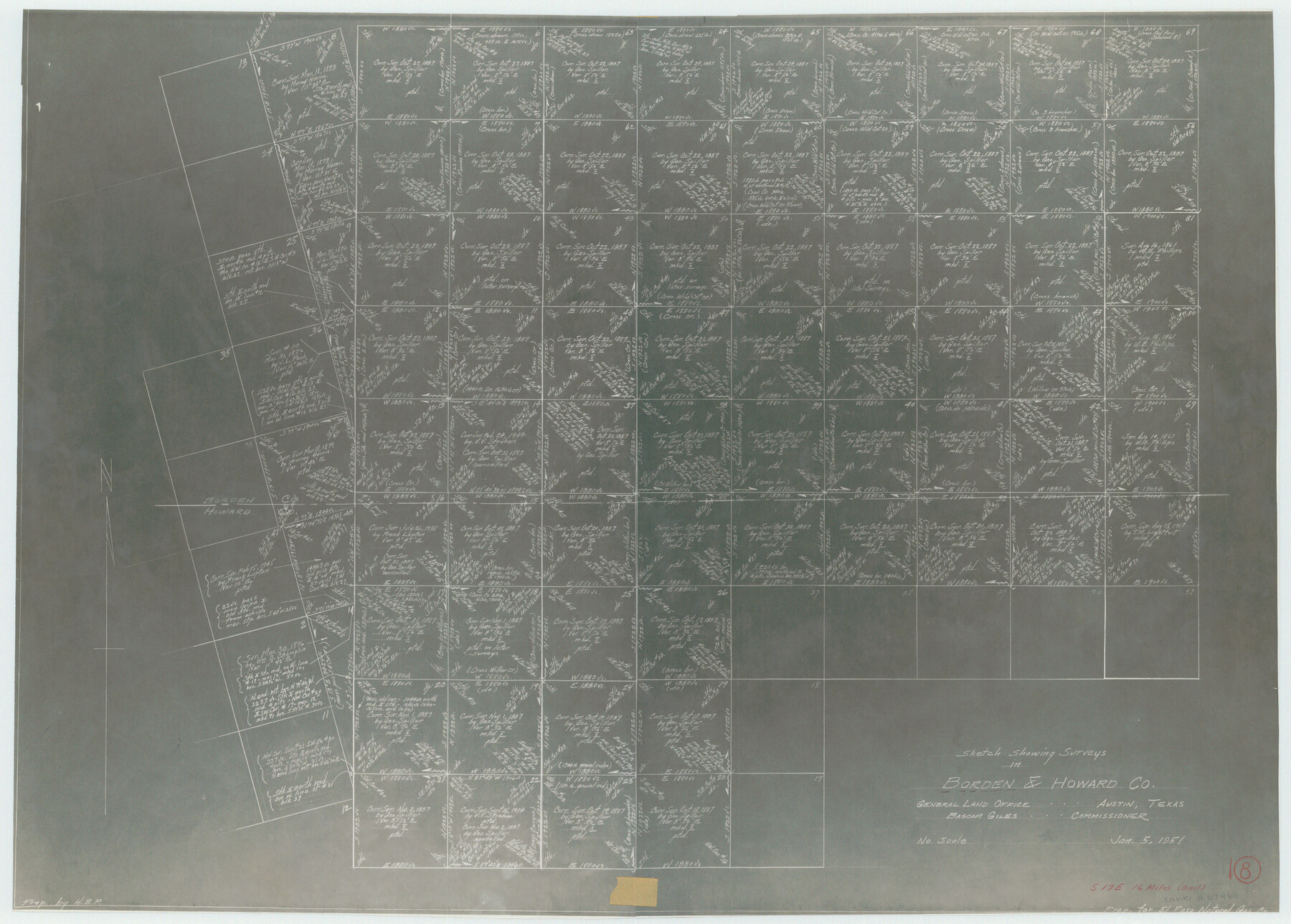
Borden County Working Sketch 8
-
Map/Doc
67468
-
Collection
General Map Collection
-
Object Dates
1/5/1951 (Creation Date)
-
People and Organizations
Bascom Giles (GLO Commissioner)
H.B. Parks (Draftsman)
-
Counties
Borden Howard
-
Subjects
Surveying Working Sketch
-
Height x Width
24.7 x 34.4 inches
62.7 x 87.4 cm
-
Comments
Surveys located about 16 miles South 17 degrees East of Gail, Texas.
Part of: General Map Collection
Oldham County

Print $40.00
- Digital $50.00
Oldham County
1925
Size 42.6 x 51.5 inches
Map/Doc 77387
North East Corner of Lamar County

Print $3.00
- Digital $50.00
North East Corner of Lamar County
Size 10.7 x 15.4 inches
Map/Doc 291
Kimble County Working Sketch 28

Print $20.00
- Digital $50.00
Kimble County Working Sketch 28
1938
Size 29.4 x 23.2 inches
Map/Doc 70096
Flight Mission No. DQN-2K, Frame 97, Calhoun County

Print $20.00
- Digital $50.00
Flight Mission No. DQN-2K, Frame 97, Calhoun County
1953
Size 18.7 x 22.4 inches
Map/Doc 84287
Armstrong County Working Sketch 11

Print $20.00
- Digital $50.00
Armstrong County Working Sketch 11
2025
Size 24.7 x 36.5 inches
Map/Doc 97507
Irion County Rolled Sketch 9

Print $20.00
- Digital $50.00
Irion County Rolled Sketch 9
1940
Size 31.9 x 30.6 inches
Map/Doc 6321
Presidio County Sketch File 78

Print $6.00
- Digital $50.00
Presidio County Sketch File 78
Size 8.4 x 14.3 inches
Map/Doc 34706
Hockley County Rolled Sketch 7

Print $40.00
- Digital $50.00
Hockley County Rolled Sketch 7
Size 41.4 x 56.6 inches
Map/Doc 9176
Frio County Rolled Sketch 21

Print $20.00
- Digital $50.00
Frio County Rolled Sketch 21
1961
Size 43.8 x 27.7 inches
Map/Doc 8911
Real County Working Sketch 42

Print $20.00
- Digital $50.00
Real County Working Sketch 42
1953
Size 40.3 x 34.5 inches
Map/Doc 71934
Tom Green County Sketch File 85

Print $4.00
- Digital $50.00
Tom Green County Sketch File 85
1912
Size 11.4 x 9.0 inches
Map/Doc 38256
Louisiana and Texas Intracoastal Waterway - Matagorda Bay to San Antonio Bay Dredging - Sheet 1

Print $20.00
- Digital $50.00
Louisiana and Texas Intracoastal Waterway - Matagorda Bay to San Antonio Bay Dredging - Sheet 1
1942
Size 31.2 x 41.2 inches
Map/Doc 61823
You may also like
Flight Mission No. BRA-6M, Frame 144, Jefferson County

Print $20.00
- Digital $50.00
Flight Mission No. BRA-6M, Frame 144, Jefferson County
1953
Size 18.5 x 22.3 inches
Map/Doc 85445
Portion of Lands in Parmer County, Texas Owned and For Sale by Capitol Freehold Land and Investment Co., Ltd.

Print $3.00
- Digital $50.00
Portion of Lands in Parmer County, Texas Owned and For Sale by Capitol Freehold Land and Investment Co., Ltd.
Size 16.7 x 11.3 inches
Map/Doc 91550
Flight Mission No. BQR-22K, Frame 39, Brazoria County

Print $20.00
- Digital $50.00
Flight Mission No. BQR-22K, Frame 39, Brazoria County
1953
Size 18.8 x 22.4 inches
Map/Doc 84123
Rains County Working Sketch 7

Print $20.00
- Digital $50.00
Rains County Working Sketch 7
1964
Size 32.6 x 38.6 inches
Map/Doc 71833
Callahan County Rolled Sketch 26

Print $20.00
- Digital $50.00
Callahan County Rolled Sketch 26
2010
Size 30.6 x 24.6 inches
Map/Doc 93453
Starr County Rolled Sketch 45

Print $40.00
- Digital $50.00
Starr County Rolled Sketch 45
Size 17.7 x 57.5 inches
Map/Doc 9914
Map of Williamson County

Print $20.00
- Digital $50.00
Map of Williamson County
1856
Size 21.8 x 27.6 inches
Map/Doc 4149
Flight Mission No. DAG-28K, Frame 33, Matagorda County

Print $20.00
- Digital $50.00
Flight Mission No. DAG-28K, Frame 33, Matagorda County
1953
Size 16.2 x 16.0 inches
Map/Doc 86601
Stonewall County Rolled Sketch 22

Print $20.00
- Digital $50.00
Stonewall County Rolled Sketch 22
1951
Size 33.3 x 30.7 inches
Map/Doc 76011
Houston County Working Sketch 33

Print $40.00
- Digital $50.00
Houston County Working Sketch 33
1987
Size 37.6 x 58.7 inches
Map/Doc 66263
Webb County Rolled Sketch 2

Print $20.00
- Digital $50.00
Webb County Rolled Sketch 2
1881
Size 19.4 x 27.6 inches
Map/Doc 8169
Childress County, Texas

Print $20.00
- Digital $50.00
Childress County, Texas
1892
Size 29.3 x 22.0 inches
Map/Doc 697