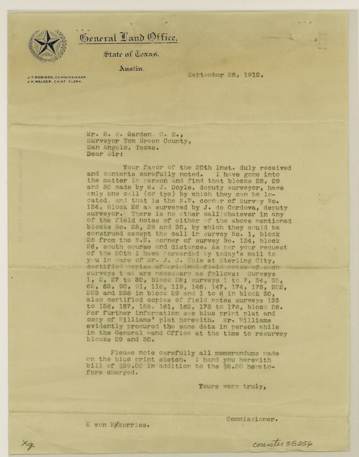
Tom Green County Sketch File 85
[Correspondence from the GLO to Tom Green County Surveyor, H.M. Garden]
-
Map/Doc
38256
-
Collection
General Map Collection
-
Object Dates
9/1912 (Creation Date)
-
Counties
Tom Green
-
Subjects
Surveying Sketch File
-
Height x Width
11.4 x 9.0 inches
29.0 x 22.9 cm
-
Medium
paper, print
Part of: General Map Collection
Flight Mission No. DQN-2K, Frame 88, Calhoun County

Print $20.00
- Digital $50.00
Flight Mission No. DQN-2K, Frame 88, Calhoun County
1953
Size 18.6 x 22.3 inches
Map/Doc 84278
San Patricio County NRC Article 33.136 Sketch 3

Print $3.00
- Digital $50.00
San Patricio County NRC Article 33.136 Sketch 3
Size 17.0 x 11.0 inches
Map/Doc 94694
Traced from Genl. Arista's map captured by the American Army under Genl. Taylor at Resaca de la Palma 9th May '46 and presented to James K. Polk, President U. States

Print $20.00
- Digital $50.00
Traced from Genl. Arista's map captured by the American Army under Genl. Taylor at Resaca de la Palma 9th May '46 and presented to James K. Polk, President U. States
1846
Size 18.1 x 27.3 inches
Map/Doc 73062

Terrell County Rolled Sketch 35

Print $20.00
- Digital $50.00
Terrell County Rolled Sketch 35
1938
Size 20.5 x 39.3 inches
Map/Doc 7940
Nueces County Rolled Sketch 23

Print $20.00
- Digital $50.00
Nueces County Rolled Sketch 23
1940
Size 44.3 x 30.3 inches
Map/Doc 9593
[Sketch for Mineral Application 1112 - Colorado River, H. E. Chambers]
![65637, [Sketch for Mineral Application 1112 - Colorado River, H. E. Chambers], General Map Collection](https://historictexasmaps.com/wmedia_w700/maps/65637.tif.jpg)
Print $20.00
- Digital $50.00
[Sketch for Mineral Application 1112 - Colorado River, H. E. Chambers]
1918
Size 5.5 x 8.5 inches
Map/Doc 65637
Jefferson County Sketch File 17

Print $4.00
- Digital $50.00
Jefferson County Sketch File 17
Size 7.9 x 8.1 inches
Map/Doc 28165
[Map showing the location of the Pecos Valley Railway through H. &. G. N. R.R. Co. Land in Reeves Co., Texas]
![64706, [Map showing the location of the Pecos Valley Railway through H. &. G. N. R.R. Co. Land in Reeves Co., Texas], General Map Collection](https://historictexasmaps.com/wmedia_w700/maps/64706.tif.jpg)
Print $40.00
- Digital $50.00
[Map showing the location of the Pecos Valley Railway through H. &. G. N. R.R. Co. Land in Reeves Co., Texas]
1891
Size 38.5 x 118.2 inches
Map/Doc 64706

Eastland County Sketch File 13

Print $4.00
- Digital $50.00
Eastland County Sketch File 13
1887
Size 8.3 x 13.0 inches
Map/Doc 21593
Zapata County Sketch File 13

Print $4.00
- Digital $50.00
Zapata County Sketch File 13
1930
Size 11.3 x 8.8 inches
Map/Doc 40952
You may also like
General Highway Map, Donley County, Texas

Print $20.00
General Highway Map, Donley County, Texas
1961
Size 24.4 x 18.3 inches
Map/Doc 79445
Wise County Sketch File 2

Print $8.00
- Digital $50.00
Wise County Sketch File 2
1856
Size 8.2 x 13.4 inches
Map/Doc 40523
Maverick County Sketch File 23a

Print $20.00
- Digital $50.00
Maverick County Sketch File 23a
Size 41.0 x 41.1 inches
Map/Doc 10537
Robertson County Working Sketch 4

Print $20.00
- Digital $50.00
Robertson County Working Sketch 4
1979
Size 19.5 x 32.1 inches
Map/Doc 63577
Town of Ropes Hockley County, Texas

Print $20.00
- Digital $50.00
Town of Ropes Hockley County, Texas
Size 29.5 x 29.8 inches
Map/Doc 92223
Old Miscellaneous File 3

Print $4.00
- Digital $50.00
Old Miscellaneous File 3
1839
Size 8.8 x 8.2 inches
Map/Doc 75414
Bandera County Working Sketch 10

Print $20.00
- Digital $50.00
Bandera County Working Sketch 10
1922
Size 17.9 x 19.4 inches
Map/Doc 67603
Rio Grande Rectification Project, El Paso and Juarez Valley

Print $20.00
- Digital $50.00
Rio Grande Rectification Project, El Paso and Juarez Valley
1935
Size 10.7 x 29.6 inches
Map/Doc 60859
Aerial Perspective of Packery Channel

Print $20.00
- Digital $50.00
Aerial Perspective of Packery Channel
1938
Size 16.5 x 19.3 inches
Map/Doc 3001
Flight Mission No. DAG-28K, Frame 32, Matagorda County

Print $20.00
- Digital $50.00
Flight Mission No. DAG-28K, Frame 32, Matagorda County
1953
Size 16.2 x 16.0 inches
Map/Doc 86600
Hardeman County Sketch File 19

Print $6.00
- Digital $50.00
Hardeman County Sketch File 19
Size 14.3 x 8.8 inches
Map/Doc 25030
Flight Mission No. BRE-2P, Frame 26, Nueces County

Print $20.00
- Digital $50.00
Flight Mission No. BRE-2P, Frame 26, Nueces County
1956
Size 18.6 x 22.7 inches
Map/Doc 86735