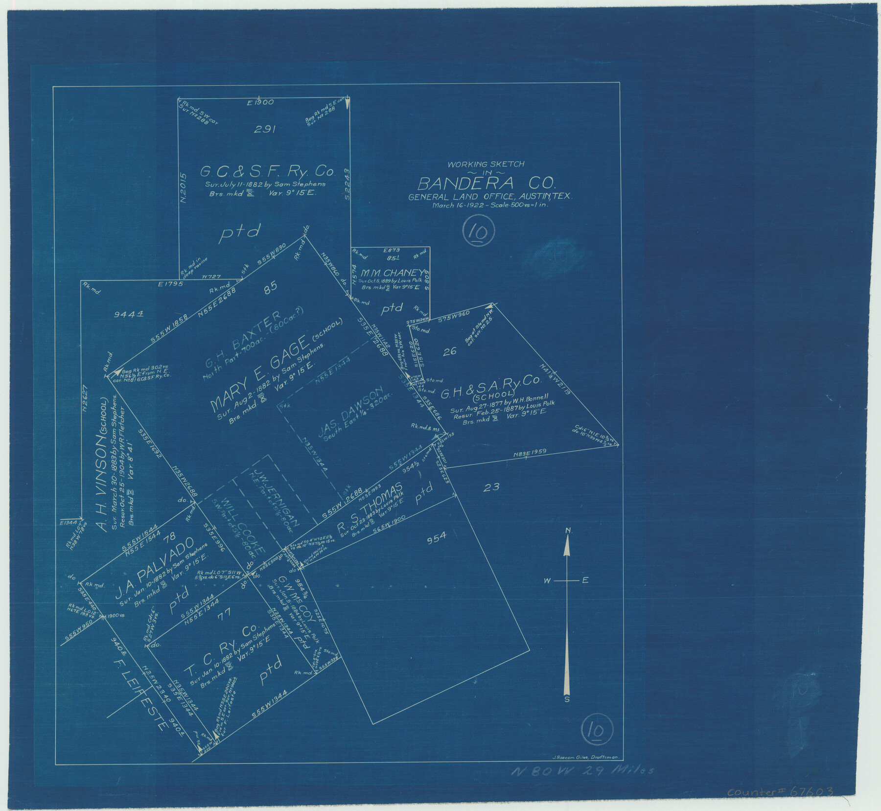
Bandera County Working Sketch 10
-
Map/Doc
67603
-
Collection
General Map Collection
-
Object Dates
3/16/1922 (Creation Date)
-
People and Organizations
J. Bascom Giles (Draftsman)
-
Counties
Bandera
-
Subjects
Surveying Working Sketch
-
Height x Width
17.9 x 19.4 inches
45.5 x 49.3 cm
-
Scale
1" = 500 varas
-
Comments
Surveys located about 29 miles North 80 degrees West of Bandera, Texas.
Part of: General Map Collection
Dallas County

Print $20.00
- Digital $50.00
Dallas County
1942
Size 45.1 x 37.1 inches
Map/Doc 77258
Flight Mission No. CRE-2R, Frame 153, Jackson County

Print $20.00
- Digital $50.00
Flight Mission No. CRE-2R, Frame 153, Jackson County
1956
Size 18.7 x 22.3 inches
Map/Doc 85364
Sutton County Rolled Sketch 68

Print $20.00
- Digital $50.00
Sutton County Rolled Sketch 68
Size 31.0 x 37.4 inches
Map/Doc 9980
Brazoria County Sketch File 59

Print $364.00
- Digital $50.00
Brazoria County Sketch File 59
1996
Size 14.9 x 8.3 inches
Map/Doc 15398
Kinney County Working Sketch 34

Print $20.00
- Digital $50.00
Kinney County Working Sketch 34
1963
Size 23.0 x 26.9 inches
Map/Doc 70216
[Beaumont, Sour Lake and Western Ry. Right of Way and Alignment - Frisco]
![64126, [Beaumont, Sour Lake and Western Ry. Right of Way and Alignment - Frisco], General Map Collection](https://historictexasmaps.com/wmedia_w700/maps/64126.tif.jpg)
Print $20.00
- Digital $50.00
[Beaumont, Sour Lake and Western Ry. Right of Way and Alignment - Frisco]
1910
Size 20.1 x 46.1 inches
Map/Doc 64126

Louisiana and Texas Intracoastal Waterway, Section 7, Galveston Bay to Brazos River and Section 8, Brazos River to Matagorda Bay

Print $20.00
- Digital $50.00
Louisiana and Texas Intracoastal Waterway, Section 7, Galveston Bay to Brazos River and Section 8, Brazos River to Matagorda Bay
1928
Size 31.3 x 42.7 inches
Map/Doc 73065
Culberson County Working Sketch 44

Print $40.00
- Digital $50.00
Culberson County Working Sketch 44
1970
Size 53.4 x 36.4 inches
Map/Doc 68498
Flight Mission No. BRA-7M, Frame 121, Jefferson County

Print $20.00
- Digital $50.00
Flight Mission No. BRA-7M, Frame 121, Jefferson County
1953
Size 18.6 x 22.4 inches
Map/Doc 85515
Angelina County

Print $40.00
- Digital $50.00
Angelina County
1899
Size 38.9 x 49.9 inches
Map/Doc 4873
Gregg County Rolled Sketch 24

Print $40.00
- Digital $50.00
Gregg County Rolled Sketch 24
Size 40.0 x 49.7 inches
Map/Doc 9075
You may also like
Lynn County Sketch File 16

Print $20.00
- Digital $50.00
Lynn County Sketch File 16
Size 31.6 x 47.5 inches
Map/Doc 10530

The Republic County of Brazoria. December 29, 1845

Print $20.00
The Republic County of Brazoria. December 29, 1845
2020
Size 14.7 x 21.8 inches
Map/Doc 96115
Andrews County Sketch File 13

Print $12.00
- Digital $50.00
Andrews County Sketch File 13
1979
Size 14.2 x 8.7 inches
Map/Doc 12863
Gulf of Mexico

Print $20.00
- Digital $50.00
Gulf of Mexico
1900
Size 18.2 x 28.1 inches
Map/Doc 72647
Wise County Rolled Sketch 8

Print $20.00
- Digital $50.00
Wise County Rolled Sketch 8
Size 24.0 x 36.0 inches
Map/Doc 93554
Amistad International Reservoir on Rio Grande 101

Print $20.00
- Digital $50.00
Amistad International Reservoir on Rio Grande 101
1950
Size 28.5 x 40.9 inches
Map/Doc 75532
Reconnoissance of Sabine River and Valley

Print $20.00
Reconnoissance of Sabine River and Valley
1863
Size 42.5 x 30.3 inches
Map/Doc 97500
Liles City, Gaines County, Texas

Print $20.00
- Digital $50.00
Liles City, Gaines County, Texas
Size 21.5 x 23.9 inches
Map/Doc 92683
Hale County Sketch File 4

Print $20.00
- Digital $50.00
Hale County Sketch File 4
1891
Size 18.8 x 16.4 inches
Map/Doc 11594
Montgomery County Working Sketch 56

Print $20.00
- Digital $50.00
Montgomery County Working Sketch 56
1961
Size 21.2 x 24.0 inches
Map/Doc 71163
Liberty County Working Sketch 81

Print $20.00
- Digital $50.00
Liberty County Working Sketch 81
1981
Size 8.0 x 24.2 inches
Map/Doc 70541