Zapata County Sketch File 13
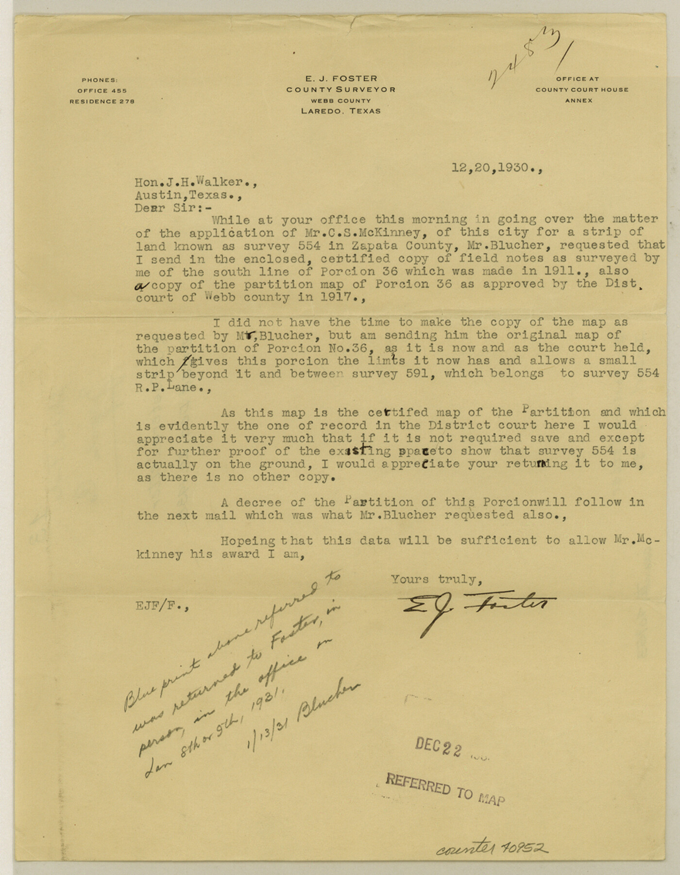
[Letter regarding application of C.S. McKinney]
-
Map/Doc
40952
-
Collection
General Map Collection
-
Object Dates
12/20/1930 (Creation Date)
-
People and Organizations
E.J. Foster (Surveyor/Engineer)
-
Counties
Zapata
-
Subjects
Surveying Sketch File
-
Height x Width
11.3 x 8.8 inches
28.7 x 22.4 cm
-
Medium
paper, print
Part of: General Map Collection
Uvalde County Working Sketch 64

Print $20.00
- Digital $50.00
Uvalde County Working Sketch 64
1998
Size 29.9 x 30.6 inches
Map/Doc 72134
Palo Pinto County Sketch File 23

Print $20.00
- Digital $50.00
Palo Pinto County Sketch File 23
1949
Size 23.5 x 15.4 inches
Map/Doc 12135
El Paso County Working Sketch 45

Print $20.00
- Digital $50.00
El Paso County Working Sketch 45
1986
Size 38.0 x 27.0 inches
Map/Doc 69067
Sutton County Rolled Sketch 61

Print $20.00
- Digital $50.00
Sutton County Rolled Sketch 61
1890
Size 27.8 x 23.4 inches
Map/Doc 7898
Flight Mission No. CLL-3N, Frame 33, Willacy County

Print $20.00
- Digital $50.00
Flight Mission No. CLL-3N, Frame 33, Willacy County
1954
Size 18.6 x 22.3 inches
Map/Doc 87090
Stonewall County Boundary File 3a

Print $68.00
- Digital $50.00
Stonewall County Boundary File 3a
Size 14.4 x 9.0 inches
Map/Doc 58970
Kimble County Working Sketch 12

Print $20.00
- Digital $50.00
Kimble County Working Sketch 12
1922
Size 27.6 x 19.5 inches
Map/Doc 70080
Oyster Creek, Texas showing connection with Brazos River & Oyster Bay by the Galveston & Brazos Canal for a Light Draft Navigation

Print $40.00
- Digital $50.00
Oyster Creek, Texas showing connection with Brazos River & Oyster Bay by the Galveston & Brazos Canal for a Light Draft Navigation
Size 18.0 x 52.9 inches
Map/Doc 96562
Crockett County Rolled Sketch 88D

Print $40.00
- Digital $50.00
Crockett County Rolled Sketch 88D
Size 43.2 x 52.0 inches
Map/Doc 8729
Mason County Rolled Sketch 4

Print $20.00
- Digital $50.00
Mason County Rolled Sketch 4
1983
Size 23.3 x 26.9 inches
Map/Doc 6677
Dickens County Sketch File 33

Print $10.00
- Digital $50.00
Dickens County Sketch File 33
1947
Size 14.5 x 9.1 inches
Map/Doc 21025
Webb County Working Sketch 33

Print $20.00
- Digital $50.00
Webb County Working Sketch 33
1938
Size 27.4 x 35.9 inches
Map/Doc 72398
You may also like
Matagorda Bay Including Lavaca and Tres Palacios Bays

Print $20.00
- Digital $50.00
Matagorda Bay Including Lavaca and Tres Palacios Bays
1992
Size 37.0 x 47.8 inches
Map/Doc 73366
Galveston Harbor and Channel, Texas - Rehabilitation of Galveston Groins - Location Plan of Rehabilitation

Print $4.00
- Digital $50.00
Galveston Harbor and Channel, Texas - Rehabilitation of Galveston Groins - Location Plan of Rehabilitation
1968
Size 16.0 x 20.6 inches
Map/Doc 73620
Live Oak County Working Sketch 30

Print $20.00
- Digital $50.00
Live Oak County Working Sketch 30
1988
Size 19.0 x 25.9 inches
Map/Doc 70615
Jackson County Working Sketch 14

Print $20.00
- Digital $50.00
Jackson County Working Sketch 14
1990
Size 31.7 x 32.2 inches
Map/Doc 66462
Presidio County Working Sketch 110

Print $20.00
- Digital $50.00
Presidio County Working Sketch 110
1981
Size 38.7 x 32.2 inches
Map/Doc 71787
Pecos County Boundary File 1

Print $2.00
- Digital $50.00
Pecos County Boundary File 1
Size 10.1 x 8.0 inches
Map/Doc 57854
Travis County Appraisal District Plat Map 2_2003

Print $20.00
- Digital $50.00
Travis County Appraisal District Plat Map 2_2003
Size 21.6 x 26.5 inches
Map/Doc 94202
Hudspeth County Sketch File 18

Print $6.00
- Digital $50.00
Hudspeth County Sketch File 18
1935
Size 11.2 x 8.7 inches
Map/Doc 26959
Pecos County Sketch File 90

Print $20.00
- Digital $50.00
Pecos County Sketch File 90
1935
Size 17.7 x 22.4 inches
Map/Doc 12183
Flight Mission No. BRA-6M, Frame 73, Jefferson County

Print $20.00
- Digital $50.00
Flight Mission No. BRA-6M, Frame 73, Jefferson County
1953
Size 18.6 x 22.3 inches
Map/Doc 85417
General Highway Map, San Jacinto County, Texas

Print $20.00
General Highway Map, San Jacinto County, Texas
1961
Size 24.6 x 18.4 inches
Map/Doc 79646
Harris County Rolled Sketch 86

Print $20.00
- Digital $50.00
Harris County Rolled Sketch 86
1933
Size 33.0 x 32.2 inches
Map/Doc 73576