Harris County Rolled Sketch 86
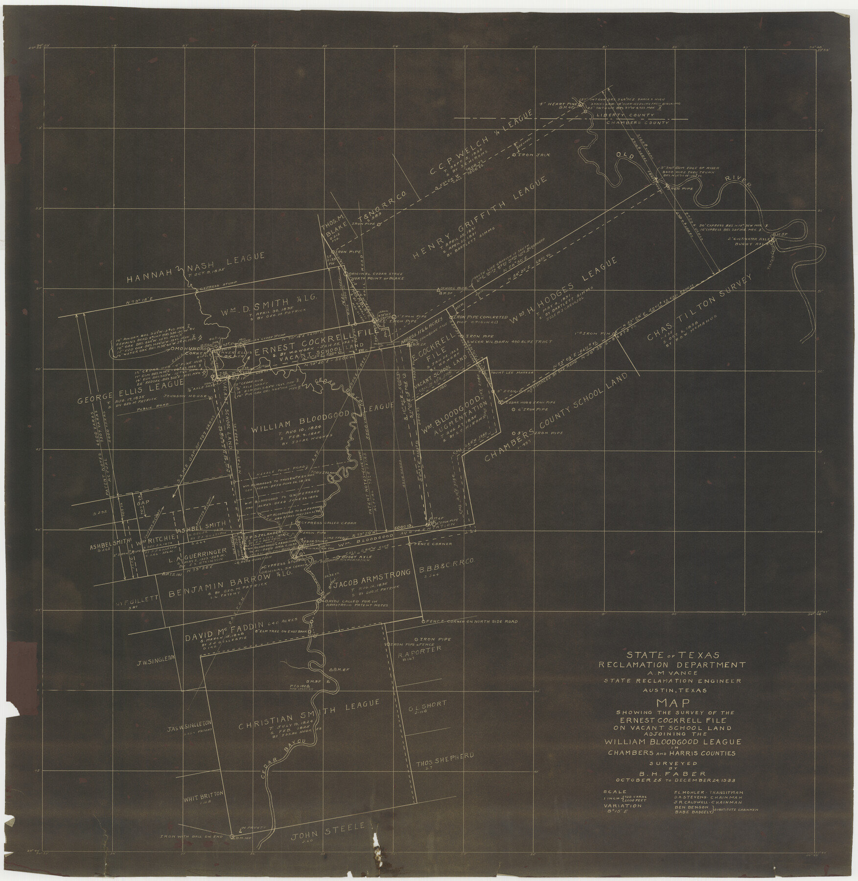
Map showing the survey of the Ernest Cockrell file on vacant school land adjoining the William Bloodgood league in Chambers and Harris Counties
-
Map/Doc
73576
-
Collection
General Map Collection
-
Object Dates
1933/12/24 (Creation Date)
1972/10/2 (File Date)
-
People and Organizations
B.H. Faber (Surveyor/Engineer)
F.L. Mohler (Chainman/Field Personnel)
D.A. Stevens (Chainman/Field Personnel)
J.R. Caldwell (Chainman/Field Personnel)
Ben Benson (Chainman/Field Personnel)
Babe Badgely (Chainman/Field Personnel)
-
Counties
Harris Chambers
-
Subjects
Surveying Rolled Sketch
-
Height x Width
33.0 x 32.2 inches
83.8 x 81.8 cm
-
Medium
van dyke, negative
-
Scale
1" = 720 varas
Part of: General Map Collection
Bastrop County Rolled Sketch 1

Print $20.00
- Digital $50.00
Bastrop County Rolled Sketch 1
Size 30.0 x 23.9 inches
Map/Doc 5121
Pecos County Rolled Sketch 39

Print $20.00
- Digital $50.00
Pecos County Rolled Sketch 39
1908
Size 21.8 x 33.2 inches
Map/Doc 7217
Aransas County NRC Article 33.136 Sketch 7

Print $46.00
- Digital $50.00
Aransas County NRC Article 33.136 Sketch 7
2000
Size 11.0 x 8.6 inches
Map/Doc 13563
Liberty County Sketch File 27

Print $5.00
- Digital $50.00
Liberty County Sketch File 27
Size 11.5 x 9.3 inches
Map/Doc 29948
Crosby County Sketch File 14a

Print $40.00
- Digital $50.00
Crosby County Sketch File 14a
Size 18.9 x 20.5 inches
Map/Doc 11249
Topographical Map of the Rio Grande, Sheet No. 7

Print $20.00
- Digital $50.00
Topographical Map of the Rio Grande, Sheet No. 7
1912
Map/Doc 89531
Flight Mission No. DCL-7C, Frame 29, Kenedy County

Print $20.00
- Digital $50.00
Flight Mission No. DCL-7C, Frame 29, Kenedy County
1943
Size 15.3 x 15.2 inches
Map/Doc 86021
Kimble County Working Sketch 29

Print $20.00
- Digital $50.00
Kimble County Working Sketch 29
1941
Size 24.7 x 15.3 inches
Map/Doc 70097
Llano County Sketch File 4

Print $6.00
- Digital $50.00
Llano County Sketch File 4
1869
Size 12.4 x 8.0 inches
Map/Doc 30353
Lubbock County Boundary File 1a

Print $20.00
- Digital $50.00
Lubbock County Boundary File 1a
Size 24.8 x 24.4 inches
Map/Doc 56487
Brewster County Working Sketch 111

Print $40.00
- Digital $50.00
Brewster County Working Sketch 111
1982
Size 21.5 x 55.9 inches
Map/Doc 67711
Brewster County Rolled Sketch 150

Print $20.00
- Digital $50.00
Brewster County Rolled Sketch 150
Size 36.4 x 25.1 inches
Map/Doc 5317
You may also like
Flight Mission No. BQR-3K, Frame 157, Brazoria County

Print $20.00
- Digital $50.00
Flight Mission No. BQR-3K, Frame 157, Brazoria County
1952
Size 18.7 x 22.3 inches
Map/Doc 83984
C No. 3 - Sea Coast of Delaware, Maryland, and part of Virginia

Print $20.00
- Digital $50.00
C No. 3 - Sea Coast of Delaware, Maryland, and part of Virginia
1852
Size 30.4 x 22.2 inches
Map/Doc 97207
Navigation Maps of Gulf Intracoastal Waterway, Port Arthur to Brownsville, Texas

Print $4.00
- Digital $50.00
Navigation Maps of Gulf Intracoastal Waterway, Port Arthur to Brownsville, Texas
1951
Size 16.6 x 21.2 inches
Map/Doc 65445
Frank Lerch's Map of San Angelo and Additions

Print $20.00
- Digital $50.00
Frank Lerch's Map of San Angelo and Additions
1880
Size 36.6 x 26.3 inches
Map/Doc 2188
Wichita County Sketch File G

Print $4.00
- Digital $50.00
Wichita County Sketch File G
1882
Size 12.8 x 8.3 inches
Map/Doc 40087
Flight Mission No. DQO-11K, Frame 18, Galveston County

Print $20.00
- Digital $50.00
Flight Mission No. DQO-11K, Frame 18, Galveston County
1952
Size 18.7 x 22.4 inches
Map/Doc 85211
Hamilton County Sketch File 15

Print $2.00
- Digital $50.00
Hamilton County Sketch File 15
1882
Size 8.0 x 11.8 inches
Map/Doc 24941
Burnet County Sketch File 3

Print $4.00
- Digital $50.00
Burnet County Sketch File 3
Size 12.3 x 8.1 inches
Map/Doc 16674
Thomas Ross Survey

Print $20.00
- Digital $50.00
Thomas Ross Survey
1954
Size 16.8 x 17.6 inches
Map/Doc 92181
Flight Mission No. BRA-16M, Frame 147, Jefferson County

Print $20.00
- Digital $50.00
Flight Mission No. BRA-16M, Frame 147, Jefferson County
1953
Size 18.6 x 22.3 inches
Map/Doc 85753
Chambers County Rolled Sketch 20

Print $1171.00
- Digital $50.00
Chambers County Rolled Sketch 20
Size 10.7 x 16.2 inches
Map/Doc 43987
Panola County Sketch File 27

Print $8.00
- Digital $50.00
Panola County Sketch File 27
1850
Size 5.4 x 7.7 inches
Map/Doc 33498