Wood County Rolled Sketch 5
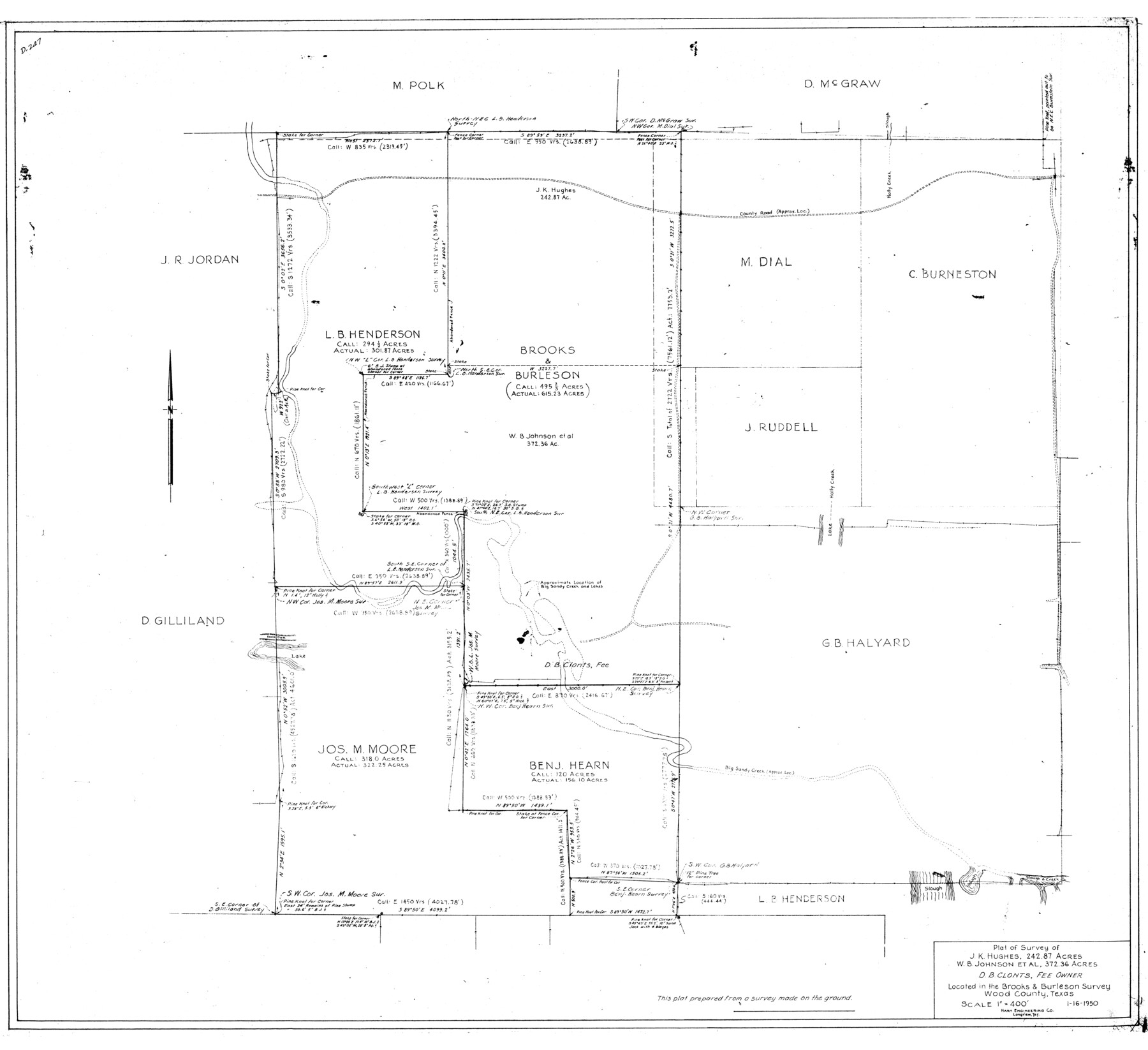
Plat of survey of J.K. Hughes, 242.87 acres, W.B. Johnson et al, 372.36 acres, D.B. Clonts, fee owner, located in the Brooks & Burleson survey, Wood County, Texas
-
Map/Doc
10161
-
Collection
General Map Collection
-
Object Dates
1950/1/16 (Creation Date)
-
Counties
Wood
-
Subjects
Surveying Rolled Sketch
-
Height x Width
36.8 x 40.2 inches
93.5 x 102.1 cm
-
Scale
1" = 400 feet
Part of: General Map Collection

Armstrong County Sketch File 7

Print $6.00
- Digital $50.00
Armstrong County Sketch File 7
1902
Size 11.1 x 8.6 inches
Map/Doc 13702
[Right of Way & Track Map, The Texas & Pacific Ry. Co. Main Line]
![64686, [Right of Way & Track Map, The Texas & Pacific Ry. Co. Main Line], General Map Collection](https://historictexasmaps.com/wmedia_w700/maps/64686.tif.jpg)
Print $20.00
- Digital $50.00
[Right of Way & Track Map, The Texas & Pacific Ry. Co. Main Line]
Size 11.0 x 19.0 inches
Map/Doc 64686
Collin County Sketch File 9

Print $4.00
- Digital $50.00
Collin County Sketch File 9
1878
Size 8.3 x 10.1 inches
Map/Doc 18870
Ector County Working Sketch 30

Print $40.00
- Digital $50.00
Ector County Working Sketch 30
1971
Size 43.2 x 64.1 inches
Map/Doc 68873
Flight Mission No. DQN-7K, Frame 36, Calhoun County

Print $20.00
- Digital $50.00
Flight Mission No. DQN-7K, Frame 36, Calhoun County
1953
Size 18.5 x 22.2 inches
Map/Doc 84474
Edwards County Working Sketch 62

Print $20.00
- Digital $50.00
Edwards County Working Sketch 62
1955
Size 21.7 x 28.5 inches
Map/Doc 68938
Van Zandt County Working Sketch 3

Print $20.00
- Digital $50.00
Van Zandt County Working Sketch 3
1923
Size 20.1 x 16.4 inches
Map/Doc 72252
Travis County Sketch File 41

Print $22.00
- Digital $50.00
Travis County Sketch File 41
1928
Size 11.7 x 30.2 inches
Map/Doc 12465
Brazoria County Sketch File 12

Print $8.00
- Digital $50.00
Brazoria County Sketch File 12
1886
Size 12.8 x 8.2 inches
Map/Doc 14967
Flight Mission No. BRA-7M, Frame 123, Jefferson County

Print $20.00
- Digital $50.00
Flight Mission No. BRA-7M, Frame 123, Jefferson County
1953
Size 18.7 x 22.3 inches
Map/Doc 85517
Flight Mission No. DQN-3K, Frame 72, Calhoun County

Print $20.00
- Digital $50.00
Flight Mission No. DQN-3K, Frame 72, Calhoun County
1953
Size 16.2 x 16.1 inches
Map/Doc 84363
You may also like
United States - Gulf Coast Texas - Southern part of Laguna Madre

Print $20.00
- Digital $50.00
United States - Gulf Coast Texas - Southern part of Laguna Madre
1941
Size 26.4 x 18.2 inches
Map/Doc 72945
[H. & T. C. Block 47]
![91834, [H. & T. C. Block 47], Twichell Survey Records](https://historictexasmaps.com/wmedia_w700/maps/91834-1.tif.jpg)
Print $20.00
- Digital $50.00
[H. & T. C. Block 47]
Size 19.4 x 18.5 inches
Map/Doc 91834
Kent County Working Sketch 8

Print $20.00
- Digital $50.00
Kent County Working Sketch 8
1952
Size 27.2 x 37.1 inches
Map/Doc 70015

Palo Pinto County, Texas

Print $20.00
- Digital $50.00
Palo Pinto County, Texas
1879
Size 17.8 x 19.0 inches
Map/Doc 529
Crane County Rolled Sketch 26

Print $20.00
- Digital $50.00
Crane County Rolled Sketch 26
2020
Size 36.5 x 24.5 inches
Map/Doc 96432
Terrell County Rolled Sketch 34

Print $20.00
- Digital $50.00
Terrell County Rolled Sketch 34
1937
Size 29.3 x 25.3 inches
Map/Doc 7939
Flight Mission No. DQN-2K, Frame 3, Calhoun County

Print $20.00
- Digital $50.00
Flight Mission No. DQN-2K, Frame 3, Calhoun County
1953
Size 18.8 x 22.4 inches
Map/Doc 84220
Brewster County Working Sketch 46

Print $20.00
- Digital $50.00
Brewster County Working Sketch 46
1948
Size 37.6 x 33.6 inches
Map/Doc 67580
Brewster County Sketch File N-28

Print $40.00
- Digital $50.00
Brewster County Sketch File N-28
Size 23.4 x 24.3 inches
Map/Doc 10973
Maps & Lists Showing Prison Lands (Oil & Gas) Leased as of June 1955

Digital $50.00
Maps & Lists Showing Prison Lands (Oil & Gas) Leased as of June 1955
Size 8.9 x 11.3 inches
Map/Doc 62870
Flight Mission No. DAG-23K, Frame 167, Matagorda County

Print $20.00
- Digital $50.00
Flight Mission No. DAG-23K, Frame 167, Matagorda County
1953
Size 15.9 x 19.1 inches
Map/Doc 86505