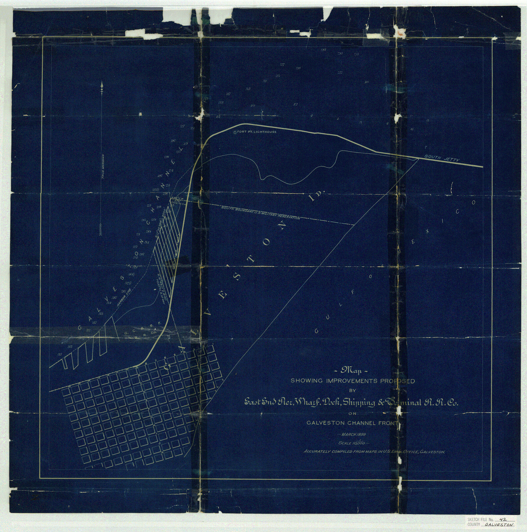
Galveston County Sketch File 42
Map showing improvements proposed by East End Pier, Wharf, Dock, Shipping & Terminal R. R. Co. on Galveston Channel Front
-
Map/Doc
11538
-
Collection
General Map Collection
-
Object Dates
4/8/1899 (File Date)
3/1899 (Creation Date)
-
People and Organizations
A. Ragland (Surveyor/Engineer)
-
Counties
Galveston
-
Subjects
Surveying Sketch File
-
Height x Width
23.9 x 23.7 inches
60.7 x 60.2 cm
-
Medium
blueprint/diazo
-
Scale
1:10,000
-
Features
Fort Point Lighthouse
South Jetty
South Boundary Line, U.S. Military Reservation
Gulf of Mexico
Galveston Channel
[Galveston]
Part of: General Map Collection
Hartley County Sketch File 14

Print $6.00
- Digital $50.00
Hartley County Sketch File 14
1926
Size 11.2 x 8.7 inches
Map/Doc 26110
Intracoastal Waterway - Laguna Madre - Chubby Island to Stover Point including the Arroyo Colorado, Texas

Print $20.00
- Digital $50.00
Intracoastal Waterway - Laguna Madre - Chubby Island to Stover Point including the Arroyo Colorado, Texas
1976
Size 15.6 x 43.8 inches
Map/Doc 75900
Harris County Sketch File AA-1

Print $20.00
- Digital $50.00
Harris County Sketch File AA-1
Size 19.0 x 26.1 inches
Map/Doc 11646
Bee County Boundary File 2

Print $10.00
- Digital $50.00
Bee County Boundary File 2
Size 8.8 x 6.8 inches
Map/Doc 50435
Wood County Working Sketch 11

Print $20.00
- Digital $50.00
Wood County Working Sketch 11
1964
Size 31.4 x 37.4 inches
Map/Doc 62011
Montgomery County Working Sketch 6

Print $20.00
- Digital $50.00
Montgomery County Working Sketch 6
1932
Size 24.8 x 32.2 inches
Map/Doc 71112
Falls County Working Sketch 3

Print $20.00
- Digital $50.00
Falls County Working Sketch 3
1922
Size 34.0 x 27.8 inches
Map/Doc 69178
Hidalgo County Rolled Sketch 7

Print $20.00
- Digital $50.00
Hidalgo County Rolled Sketch 7
1905
Size 20.4 x 26.1 inches
Map/Doc 6208
Stonewall County

Print $20.00
- Digital $50.00
Stonewall County
1888
Size 17.8 x 24.6 inches
Map/Doc 89055
Liberty County Rolled Sketch G

Print $20.00
- Digital $50.00
Liberty County Rolled Sketch G
Size 25.7 x 25.2 inches
Map/Doc 6622
Wood County Boundary File 97

Print $2.00
- Digital $50.00
Wood County Boundary File 97
Size 9.4 x 4.5 inches
Map/Doc 60195
Travis County Boundary File 6

Print $109.00
- Digital $50.00
Travis County Boundary File 6
Size 14.6 x 9.1 inches
Map/Doc 59433
You may also like
Map of Ramon Musquiz Survey, Meanders of Lavaca & Navidad Rivers, Menefee & Redfish Lakes

Print $20.00
- Digital $50.00
Map of Ramon Musquiz Survey, Meanders of Lavaca & Navidad Rivers, Menefee & Redfish Lakes
1934
Size 24.4 x 18.0 inches
Map/Doc 65453
Tom Green County Sketch File 62

Print $20.00
- Digital $50.00
Tom Green County Sketch File 62
1890
Size 27.7 x 43.9 inches
Map/Doc 10405
Limestone County Sketch File 14

Print $4.00
- Digital $50.00
Limestone County Sketch File 14
1883
Size 10.7 x 8.2 inches
Map/Doc 30179
Lampasas County Working Sketch 10

Print $20.00
- Digital $50.00
Lampasas County Working Sketch 10
1963
Size 32.2 x 42.9 inches
Map/Doc 70287
Liberty County Working Sketch 84

Print $20.00
- Digital $50.00
Liberty County Working Sketch 84
1981
Size 21.3 x 18.4 inches
Map/Doc 70544
El Paso County Working Sketch 21

Print $20.00
- Digital $50.00
El Paso County Working Sketch 21
1960
Size 37.8 x 30.9 inches
Map/Doc 69043
Crane County State of Texas

Print $20.00
- Digital $50.00
Crane County State of Texas
1889
Size 22.9 x 17.6 inches
Map/Doc 4524
Dimmit County Working Sketch 57

Print $20.00
- Digital $50.00
Dimmit County Working Sketch 57
2008
Size 26.1 x 31.7 inches
Map/Doc 88847
Hood County Sketch File 21

Print $12.00
- Digital $50.00
Hood County Sketch File 21
1873
Size 7.8 x 6.7 inches
Map/Doc 26609
Flight Mission No. DIX-5P, Frame 114, Aransas County

Print $20.00
- Digital $50.00
Flight Mission No. DIX-5P, Frame 114, Aransas County
1956
Size 17.4 x 17.6 inches
Map/Doc 83793
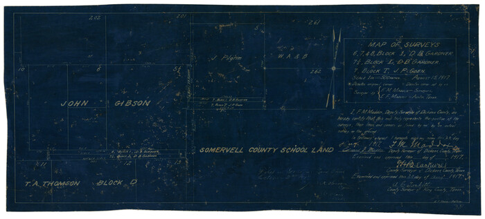
Map of Surveys 6, 7, & 8, Block 1, D.B. Gardner 7 1/2, Block L, D.B. Gardner 7, Block T, J.P. Goen
Print $20.00
- Digital $50.00
Map of Surveys 6, 7, & 8, Block 1, D.B. Gardner 7 1/2, Block L, D.B. Gardner 7, Block T, J.P. Goen
1917
Size 11.0 x 22.6 inches
Map/Doc 10762
Boundary Between the United States & Mexico Agreed Upon by the Joint Commission under the Treaty of Guadalupe Hidalgo

Print $4.00
- Digital $50.00
Boundary Between the United States & Mexico Agreed Upon by the Joint Commission under the Treaty of Guadalupe Hidalgo
1853
Size 24.4 x 18.8 inches
Map/Doc 65395