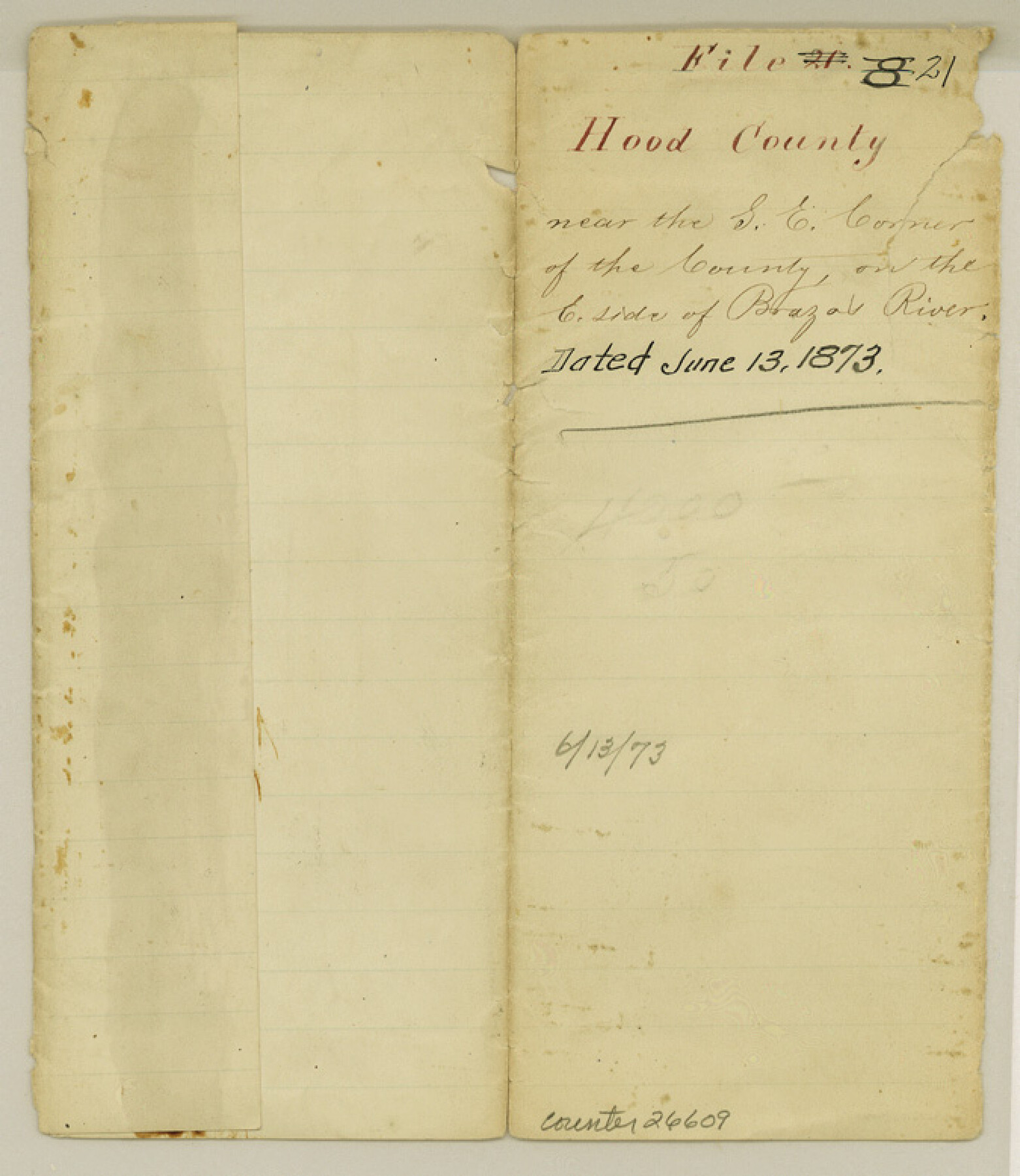
Hood County Sketch File 21
[Sketch and report in southeast corner of the county on east side of Brazos River]
-
Map/Doc
26609
-
Collection
General Map Collection
-
Object Dates
6/13/1873 (Creation Date)
6/13/1873 (File Date)
5/29/1875 (Correspondence Date)
-
People and Organizations
C.F. Rodgers (Surveyor/Engineer)
-
Counties
Hood Johnson
-
Subjects
Surveying Sketch File
-
Height x Width
7.8 x 6.7 inches
19.8 x 17.0 cm
-
Medium
paper, manuscript
-
Features
Brazos River
Part of: General Map Collection
Map of Starr County

Print $20.00
- Digital $50.00
Map of Starr County
1896
Size 43.7 x 26.9 inches
Map/Doc 4050
Duval County Working Sketch 42

Print $20.00
- Digital $50.00
Duval County Working Sketch 42
1976
Size 24.9 x 31.1 inches
Map/Doc 68766
[Sketch for Mineral Application 24072, San Jacinto River]
![65603, [Sketch for Mineral Application 24072, San Jacinto River], General Map Collection](https://historictexasmaps.com/wmedia_w700/maps/65603.tif.jpg)
Print $20.00
- Digital $50.00
[Sketch for Mineral Application 24072, San Jacinto River]
1929
Size 23.4 x 17.6 inches
Map/Doc 65603

Stonewall County Rolled Sketch 22

Print $20.00
- Digital $50.00
Stonewall County Rolled Sketch 22
1951
Size 33.3 x 30.7 inches
Map/Doc 76011

Wilson County Working Sketch 13

Print $40.00
- Digital $50.00
Wilson County Working Sketch 13
1985
Size 23.9 x 53.5 inches
Map/Doc 72593
El Paso County Rolled Sketch 52

Print $20.00
- Digital $50.00
El Paso County Rolled Sketch 52
1929
Size 18.5 x 24.4 inches
Map/Doc 5848
Chart of the Rio Bravo del Norte traced from a survey made by Henry Austin by Lieut. Bowman, 3d. Infy.

Print $20.00
- Digital $50.00
Chart of the Rio Bravo del Norte traced from a survey made by Henry Austin by Lieut. Bowman, 3d. Infy.
1866
Size 18.1 x 27.2 inches
Map/Doc 72890
Reeves County Rolled Sketch 33

Print $20.00
- Digital $50.00
Reeves County Rolled Sketch 33
Size 24.2 x 36.5 inches
Map/Doc 7502
Tanglewood, Station Map-Tracks & Structures-Lands, San Antonio & Aransas Pass Railway Co., Station 4804+179 to Station 4856+179

Print $4.00
- Digital $50.00
Tanglewood, Station Map-Tracks & Structures-Lands, San Antonio & Aransas Pass Railway Co., Station 4804+179 to Station 4856+179
1919
Size 11.7 x 18.6 inches
Map/Doc 62569
Bosque County Sketch File 18

Print $4.00
- Digital $50.00
Bosque County Sketch File 18
1863
Size 13.5 x 8.4 inches
Map/Doc 14792
You may also like
Flight Mission No. DQO-2K, Frame 148, Galveston County

Print $20.00
- Digital $50.00
Flight Mission No. DQO-2K, Frame 148, Galveston County
1952
Size 18.8 x 22.5 inches
Map/Doc 85045
Map of the United States of America with its territories and districts including also a part of upper and lower Canada and Mexico

Print $20.00
- Digital $50.00
Map of the United States of America with its territories and districts including also a part of upper and lower Canada and Mexico
1835
Size 31.3 x 44.7 inches
Map/Doc 93852
Flight Mission No. DQO-2K, Frame 136, Galveston County

Print $20.00
- Digital $50.00
Flight Mission No. DQO-2K, Frame 136, Galveston County
1952
Size 18.8 x 22.6 inches
Map/Doc 85033
The Republic County of Austin. January 28, 1841

Print $20.00
The Republic County of Austin. January 28, 1841
2020
Size 14.7 x 21.7 inches
Map/Doc 96085
The Republic County of Milam. Proposed, Late Fall 1837

Print $20.00
The Republic County of Milam. Proposed, Late Fall 1837
2020
Size 19.9 x 21.7 inches
Map/Doc 96225
Dimmit County Working Sketch 15

Print $20.00
- Digital $50.00
Dimmit County Working Sketch 15
1942
Size 19.0 x 34.5 inches
Map/Doc 68676
Kinney County Working Sketch 12

Print $20.00
- Digital $50.00
Kinney County Working Sketch 12
1941
Size 26.7 x 32.1 inches
Map/Doc 70194
Hartley County Working Sketch 8

Print $20.00
- Digital $50.00
Hartley County Working Sketch 8
1982
Size 34.0 x 32.6 inches
Map/Doc 66058
Mason County Working Sketch 12

Print $20.00
- Digital $50.00
Mason County Working Sketch 12
1951
Size 28.1 x 23.6 inches
Map/Doc 70848
Sketch in Northwest part Crockett County

Print $20.00
- Digital $50.00
Sketch in Northwest part Crockett County
Size 14.5 x 26.3 inches
Map/Doc 90475
Parker County Sketch File 41

Print $4.00
- Digital $50.00
Parker County Sketch File 41
1877
Size 8.9 x 10.6 inches
Map/Doc 33587
Crockett County Working Sketch 6

Print $20.00
- Digital $50.00
Crockett County Working Sketch 6
Size 20.7 x 21.7 inches
Map/Doc 68339