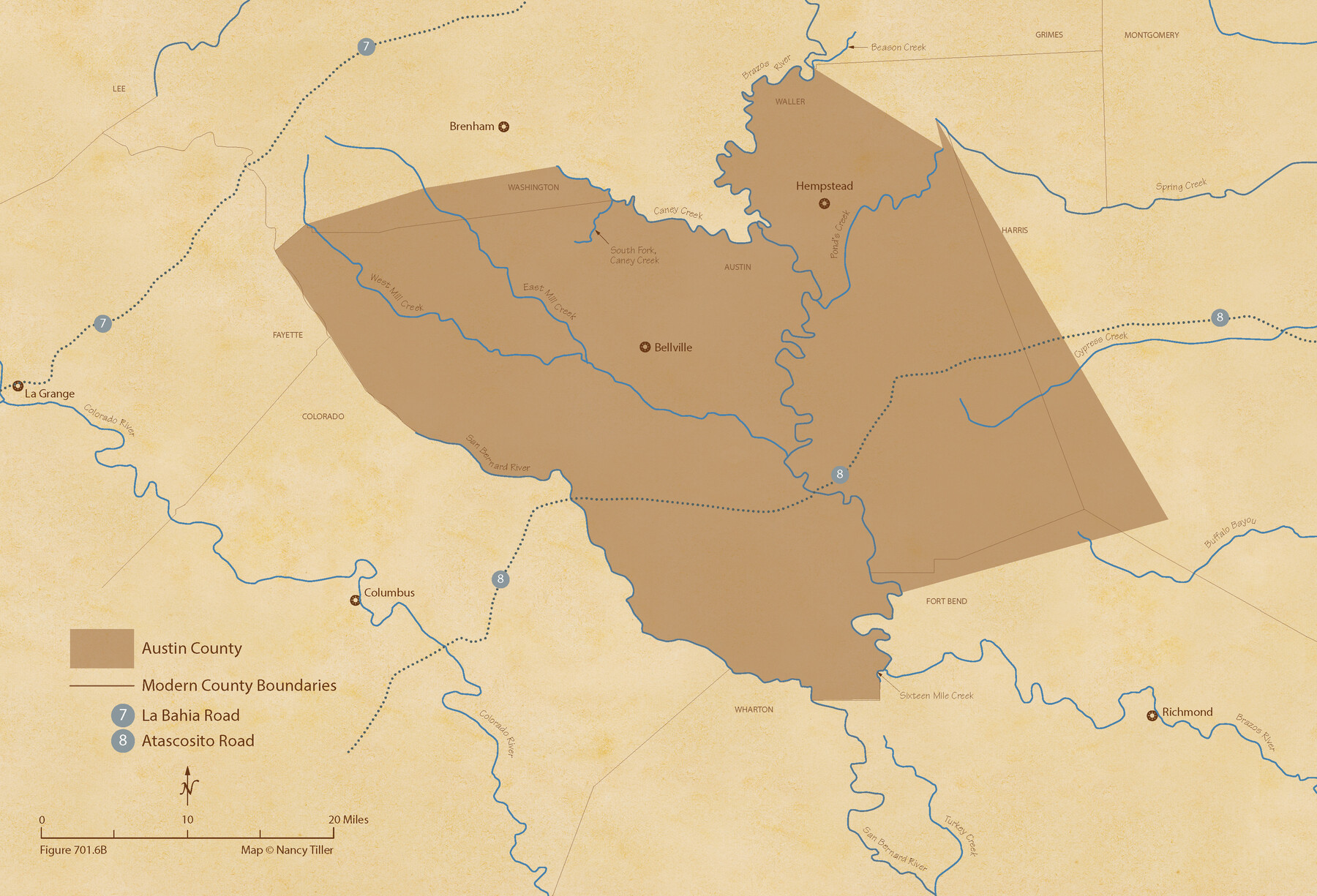
The Republic County of Austin. January 28, 1841
Figure No. 701.6 from 'A Boundary Atlas of Texas, 1821-1845' by Jim Tiller
-
Map/Doc
96085
-
Collection
Nancy and Jim Tiller Digital Collection
-
Object Dates
2020/1/1 (Creation Date)
-
People and Organizations
Jim Tiller (Author)
Nancy Tiller (Cartographer)
Gang Gong (GIS Professional)
-
Counties
Austin
-
Subjects
Atlas County Republic of Texas Texas Boundaries
-
Height x Width
14.7 x 21.7 inches
37.3 x 55.1 cm
-
Medium
digital image
-
Comments
To purchase a digital PDF copy of "A Boundary Atlas of Texas, 1821-1845" see 96437.
Part of: Nancy and Jim Tiller Digital Collection
The Mexican Municipality of Matagorda. Created, March 6, 1834

Print $20.00
The Mexican Municipality of Matagorda. Created, March 6, 1834
2020
Size 15.9 x 21.7 inches
Map/Doc 96025
The Land Offices. No. 2, San Augustine, December 22, 1836

Print $20.00
The Land Offices. No. 2, San Augustine, December 22, 1836
2020
Size 19.7 x 18.4 inches
Map/Doc 96415
The Republic County of San Patricio. 1840

Print $20.00
The Republic County of San Patricio. 1840
2020
Size 22.2 x 21.7 inches
Map/Doc 96276
Leftwich Empresario Colony. April 15, 1825

Print $20.00
Leftwich Empresario Colony. April 15, 1825
2020
Size 19.5 x 21.7 inches
Map/Doc 95997
The Judicial District/County of Madison. Abolished, Spring 1842

Print $20.00
The Judicial District/County of Madison. Abolished, Spring 1842
2020
Size 18.2 x 21.7 inches
Map/Doc 96334
The Republic County of Victoria. December 29, 1845

Print $20.00
The Republic County of Victoria. December 29, 1845
2020
Size 24.3 x 21.7 inches
Map/Doc 96301
The Mexican Municipality of Mina. Created, April 1834

Print $20.00
The Mexican Municipality of Mina. Created, April 1834
2020
Size 10.7 x 21.7 inches
Map/Doc 96028
The Republic County of Jackson. Boundaries Defined, December 29, 1837

Print $20.00
The Republic County of Jackson. Boundaries Defined, December 29, 1837
2020
Size 15.6 x 21.8 inches
Map/Doc 96184
The Mexican Municipality of Matagorda. December 28, 1834

Print $20.00
The Mexican Municipality of Matagorda. December 28, 1834
2020
Size 15.9 x 21.7 inches
Map/Doc 96026
The Mexican Department of Bexar. May 6, 1833

Print $20.00
The Mexican Department of Bexar. May 6, 1833
2020
Size 16.0 x 21.6 inches
Map/Doc 95969
The Chief Justice County of Sabine. Lands in Conflict with Jasper and San Augustine Counties

Print $20.00
The Chief Justice County of Sabine. Lands in Conflict with Jasper and San Augustine Counties
2020
Size 20.0 x 21.7 inches
Map/Doc 96069
From Citizens of Gonzales County for the Creation of a New Judicial County (Unnamed), December 14, 1841

Print $20.00
From Citizens of Gonzales County for the Creation of a New Judicial County (Unnamed), December 14, 1841
2020
Size 24.1 x 21.7 inches
Map/Doc 96410
You may also like
Bell County Sketch File 6

Print $4.00
- Digital $50.00
Bell County Sketch File 6
Size 6.3 x 7.7 inches
Map/Doc 14373
Map of Townsite of Swearingen, Cottle County, Texas

Print $20.00
- Digital $50.00
Map of Townsite of Swearingen, Cottle County, Texas
1918
Size 28.8 x 17.4 inches
Map/Doc 4464
Nueces County Rolled Sketch 113A

Print $20.00
- Digital $50.00
Nueces County Rolled Sketch 113A
1972
Size 19.1 x 24.4 inches
Map/Doc 7121
[Blocks S1, O6, O, A1, A2, A3, A4, JK, JK2, JK4, and JD]
![90657, [Blocks S1, O6, O, A1, A2, A3, A4, JK, JK2, JK4, and JD], Twichell Survey Records](https://historictexasmaps.com/wmedia_w700/maps/90657-1.tif.jpg)
Print $20.00
- Digital $50.00
[Blocks S1, O6, O, A1, A2, A3, A4, JK, JK2, JK4, and JD]
Size 21.3 x 22.4 inches
Map/Doc 90657
United States Population Distribution by County and Territory, per the U.S. Census of 1890

United States Population Distribution by County and Territory, per the U.S. Census of 1890
2025
Size 8.5 x 11.0 inches
Map/Doc 97480
Flight Mission No. CGI-4N, Frame 179, Cameron County

Print $20.00
- Digital $50.00
Flight Mission No. CGI-4N, Frame 179, Cameron County
1955
Size 18.5 x 22.2 inches
Map/Doc 84682
Brazoria County NRC Article 33.136 Sketch 20

Print $36.00
- Digital $50.00
Brazoria County NRC Article 33.136 Sketch 20
2020
Map/Doc 96878
Hansford County Boundary File 1a

Print $2.00
- Digital $50.00
Hansford County Boundary File 1a
Size 11.2 x 8.8 inches
Map/Doc 54244
Gaines County Working Sketch 21

Print $20.00
- Digital $50.00
Gaines County Working Sketch 21
1970
Size 37.8 x 45.4 inches
Map/Doc 69321
Gaines County Rolled Sketch 31

Print $20.00
- Digital $50.00
Gaines County Rolled Sketch 31
1964
Size 20.2 x 25.5 inches
Map/Doc 5944
Swisher County Rolled Sketch 6

Print $20.00
- Digital $50.00
Swisher County Rolled Sketch 6
1941
Size 43.0 x 27.6 inches
Map/Doc 7907
Wichita County Sketch File 32

Print $12.00
- Digital $50.00
Wichita County Sketch File 32
1939
Size 14.2 x 8.8 inches
Map/Doc 40146