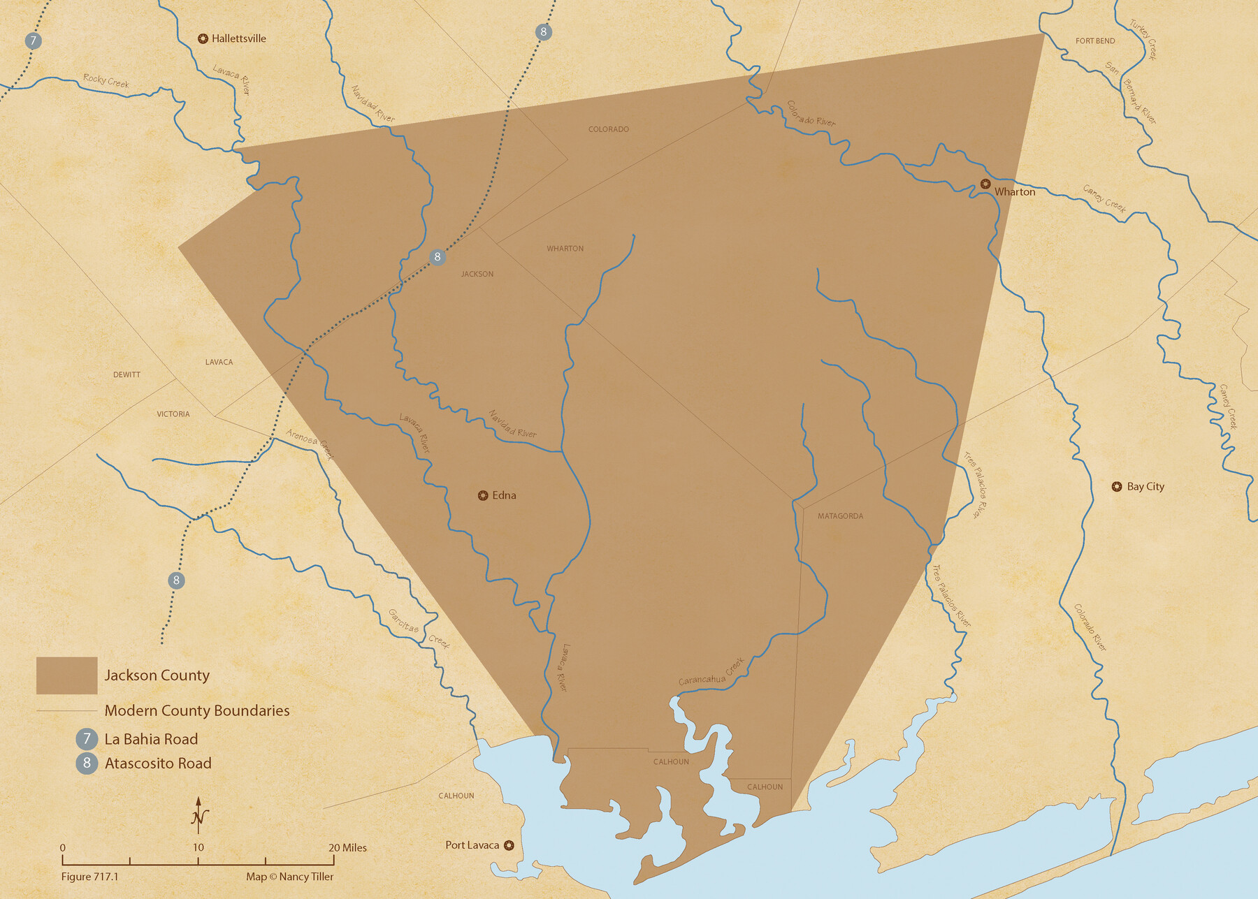
The Republic County of Jackson. Boundaries Defined, December 29, 1837
Figure No. 717.1 from 'A Boundary Atlas of Texas, 1821-1845' by Jim Tiller
-
Map/Doc
96184
-
Collection
Nancy and Jim Tiller Digital Collection
-
Object Dates
2020/1/1 (Creation Date)
-
People and Organizations
Jim Tiller (Author)
Nancy Tiller (Cartographer)
Gang Gong (GIS Professional)
-
Counties
Jackson
-
Subjects
Atlas County Republic of Texas Texas Boundaries
-
Height x Width
15.6 x 21.8 inches
39.6 x 55.4 cm
-
Medium
digital image
-
Comments
To purchase a digital PDF copy of "A Boundary Atlas of Texas, 1821-1845" see 96437.
Part of: Nancy and Jim Tiller Digital Collection
The Chief Justice County of Colorado. Undated

Print $20.00
The Chief Justice County of Colorado. Undated
2020
Size 14.8 x 21.6 inches
Map/Doc 96044
The Republic County of Houston. Spring 1842

Print $20.00
The Republic County of Houston. Spring 1842
2020
Size 19.7 x 21.8 inches
Map/Doc 96182
The Mexican Municipality of Colorado. Created, January 11, 1836

Print $20.00
The Mexican Municipality of Colorado. Created, January 11, 1836
2020
Size 15.7 x 21.6 inches
Map/Doc 96019
Zavala Empresario Colony. March 12, 1829

Print $20.00
Zavala Empresario Colony. March 12, 1829
2020
Size 24.7 x 21.7 inches
Map/Doc 96012
Republic Counties. January 1, 1840

Print $20.00
Republic Counties. January 1, 1840
2020
Size 24.5 x 21.7 inches
Map/Doc 96313
The Republic County of San Augustine. Boundaries Defined, December 14, 1837

Print $20.00
The Republic County of San Augustine. Boundaries Defined, December 14, 1837
2020
Size 18.8 x 21.7 inches
Map/Doc 96271
The Republic County of Jackson. January 29, 1842

Print $20.00
The Republic County of Jackson. January 29, 1842
2020
Size 15.6 x 21.8 inches
Map/Doc 96189
The Nashville Association/Company Empresario Colony. October 15, 1827

Print $20.00
The Nashville Association/Company Empresario Colony. October 15, 1827
2020
Size 14.7 x 21.7 inches
Map/Doc 96001
The Judicial District/County of Pashcal. Created, January 28, 1841

Print $20.00
The Judicial District/County of Pashcal. Created, January 28, 1841
2020
Size 15.0 x 21.7 inches
Map/Doc 96343
The Republic County of Lamar. Spring 1842

Print $20.00
The Republic County of Lamar. Spring 1842
2020
Size 16.4 x 21.7 inches
Map/Doc 96204
The Chief Justice County of Nacogdoches. Lands in Conflict with Red River and Washington Counties

Print $20.00
The Chief Justice County of Nacogdoches. Lands in Conflict with Red River and Washington Counties
2020
Size 17.6 x 21.7 inches
Map/Doc 96064
The Republic County of Liberty. January 20, 1841

Print $20.00
The Republic County of Liberty. January 20, 1841
2020
Size 19.9 x 21.7 inches
Map/Doc 96209
You may also like
Galveston County Working Sketch Graphic Index

Print $40.00
- Digital $50.00
Galveston County Working Sketch Graphic Index
1939
Size 42.8 x 55.4 inches
Map/Doc 76551

Kinney County Working Sketch 3

Print $20.00
- Digital $50.00
Kinney County Working Sketch 3
Size 20.3 x 17.6 inches
Map/Doc 70185
Crockett County Working Sketch 15

Print $20.00
- Digital $50.00
Crockett County Working Sketch 15
1916
Size 16.2 x 20.4 inches
Map/Doc 68348
Flight Mission No. DIX-5P, Frame 150, Aransas County

Print $20.00
- Digital $50.00
Flight Mission No. DIX-5P, Frame 150, Aransas County
1956
Size 17.8 x 18.3 inches
Map/Doc 83812
Panola County Working Sketch 24

Print $20.00
- Digital $50.00
Panola County Working Sketch 24
1957
Map/Doc 71433
McLennan County Sketch File 43

Print $4.00
- Digital $50.00
McLennan County Sketch File 43
1873
Size 10.0 x 8.1 inches
Map/Doc 31333
Myrick Farms Lubbock & Hockley Counties

Print $20.00
- Digital $50.00
Myrick Farms Lubbock & Hockley Counties
Size 21.3 x 21.5 inches
Map/Doc 92830
Hemphill County, State of Texas

Print $20.00
- Digital $50.00
Hemphill County, State of Texas
1888
Size 22.0 x 17.4 inches
Map/Doc 6187
Maps of Gulf Intracoastal Waterway, Texas - Sabine River to the Rio Grande and connecting waterways including ship channels

Print $20.00
- Digital $50.00
Maps of Gulf Intracoastal Waterway, Texas - Sabine River to the Rio Grande and connecting waterways including ship channels
1966
Size 14.4 x 20.6 inches
Map/Doc 61996
Tarrant County Sketch File 25

Print $4.00
- Digital $50.00
Tarrant County Sketch File 25
1873
Size 8.2 x 8.6 inches
Map/Doc 37737