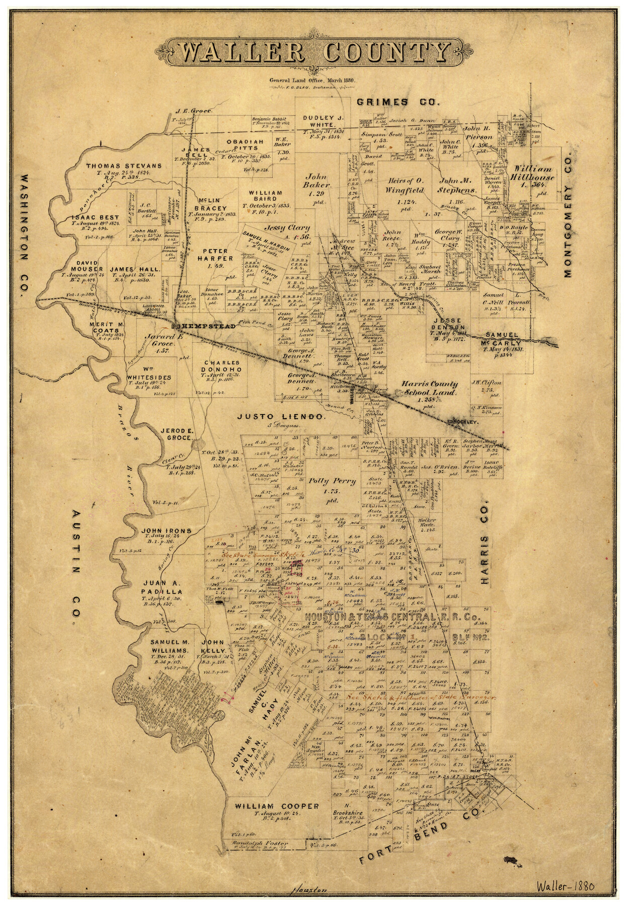
Waller County
-
Map/Doc
4121
-
Collection
General Map Collection
-
Object Dates
3/1880 (Creation Date)
-
People and Organizations
Texas General Land Office (Publisher)
F.G. Blau (Compiler)
F.G. Blau (Draftsman)
-
Counties
Waller
-
Subjects
County
-
Height x Width
20.4 x 14.5 inches
51.8 x 36.8 cm
-
Features
Lynn Bayou
Hady's Creek
Iron's Creek
Besse's [sic] Creek
Brazos River
Clear Creek
Hockley
Mound Creek
Waller
Walnut Creek
Donahoe Creek
Hempstead
Fish Pond Creek
Spring Creek
Dry Creek
H&TC
Brushy Creek
Birch Creek
Cedar Creek
Part of: General Map Collection
United States - Gulf Coast - From Latitude 26° 33' to the Rio Grande Texas

Print $20.00
- Digital $50.00
United States - Gulf Coast - From Latitude 26° 33' to the Rio Grande Texas
1916
Size 27.8 x 18.2 inches
Map/Doc 72840
Henderson County Rolled Sketch 11

Print $20.00
- Digital $50.00
Henderson County Rolled Sketch 11
1915
Size 29.5 x 42.6 inches
Map/Doc 75947
Harris County Sketch File 17

Print $4.00
- Digital $50.00
Harris County Sketch File 17
1860
Size 5.8 x 5.6 inches
Map/Doc 25361
Callahan County Sketch File 6

Print $42.00
- Digital $50.00
Callahan County Sketch File 6
1858
Size 8.2 x 6.4 inches
Map/Doc 35859

Flight Mission No. CRC-5R, Frame 30, Chambers County

Print $20.00
- Digital $50.00
Flight Mission No. CRC-5R, Frame 30, Chambers County
1956
Size 18.6 x 22.4 inches
Map/Doc 84949
Brewster County Sketch File 20

Print $40.00
- Digital $50.00
Brewster County Sketch File 20
1946
Size 19.1 x 15.2 inches
Map/Doc 10979
Parker County Sketch File 39

Print $4.00
- Digital $50.00
Parker County Sketch File 39
Size 8.0 x 12.7 inches
Map/Doc 33583
Colorado County

Print $20.00
- Digital $50.00
Colorado County
1847
Size 23.7 x 31.4 inches
Map/Doc 3424
Dickens County Sketch File 19

Print $4.00
- Digital $50.00
Dickens County Sketch File 19
1910
Size 8.4 x 7.5 inches
Map/Doc 20982
Motley County Boundary File 2e

Print $40.00
- Digital $50.00
Motley County Boundary File 2e
Size 29.4 x 96.1 inches
Map/Doc 57561
Leon County Working Sketch 50

Print $20.00
- Digital $50.00
Leon County Working Sketch 50
1981
Size 28.9 x 24.2 inches
Map/Doc 70449
You may also like
Map of Parts of Dawson and Borden Counties

Print $20.00
- Digital $50.00
Map of Parts of Dawson and Borden Counties
Size 22.7 x 17.6 inches
Map/Doc 92034
[Skeleton Sketch of G. C. & S. F. Block 194 and sections 60-65, I. & G. N. Block 1]
![93187, [Skeleton Sketch of G. C. & S. F. Block 194 and sections 60-65, I. & G. N. Block 1], Twichell Survey Records](https://historictexasmaps.com/wmedia_w700/maps/93187-1.tif.jpg)
Print $40.00
- Digital $50.00
[Skeleton Sketch of G. C. & S. F. Block 194 and sections 60-65, I. & G. N. Block 1]
Size 74.5 x 43.4 inches
Map/Doc 93187
Oldham County Sketch File 10

Print $8.00
- Digital $50.00
Oldham County Sketch File 10
Size 12.7 x 8.3 inches
Map/Doc 33243
Frio County Rolled Sketch 26

Print $20.00
- Digital $50.00
Frio County Rolled Sketch 26
1994
Size 28.1 x 38.9 inches
Map/Doc 5926
Randall County Rolled Sketch 8

Print $20.00
- Digital $50.00
Randall County Rolled Sketch 8
Size 32.9 x 40.6 inches
Map/Doc 7429
Val Verde County Working Sketch 98

Print $20.00
- Digital $50.00
Val Verde County Working Sketch 98
1980
Size 26.5 x 31.8 inches
Map/Doc 72233
Refugio County Working Sketch 14

Print $20.00
- Digital $50.00
Refugio County Working Sketch 14
1961
Size 25.7 x 21.7 inches
Map/Doc 63523
Harris County Working Sketch 126

Print $20.00
- Digital $50.00
Harris County Working Sketch 126
1995
Size 14.5 x 30.0 inches
Map/Doc 66018
Map of McLennan County

Print $40.00
- Digital $50.00
Map of McLennan County
1896
Size 48.8 x 53.7 inches
Map/Doc 7952
Dickens County

Print $20.00
- Digital $50.00
Dickens County
1915
Size 42.4 x 39.3 inches
Map/Doc 4722
Map of Waller County

Print $20.00
- Digital $50.00
Map of Waller County
1897
Size 46.7 x 28.9 inches
Map/Doc 16915
Houston Ship Channel, Alexander Island to Carpenter Bayou

Print $20.00
- Digital $50.00
Houston Ship Channel, Alexander Island to Carpenter Bayou
1975
Size 35.1 x 46.6 inches
Map/Doc 69911