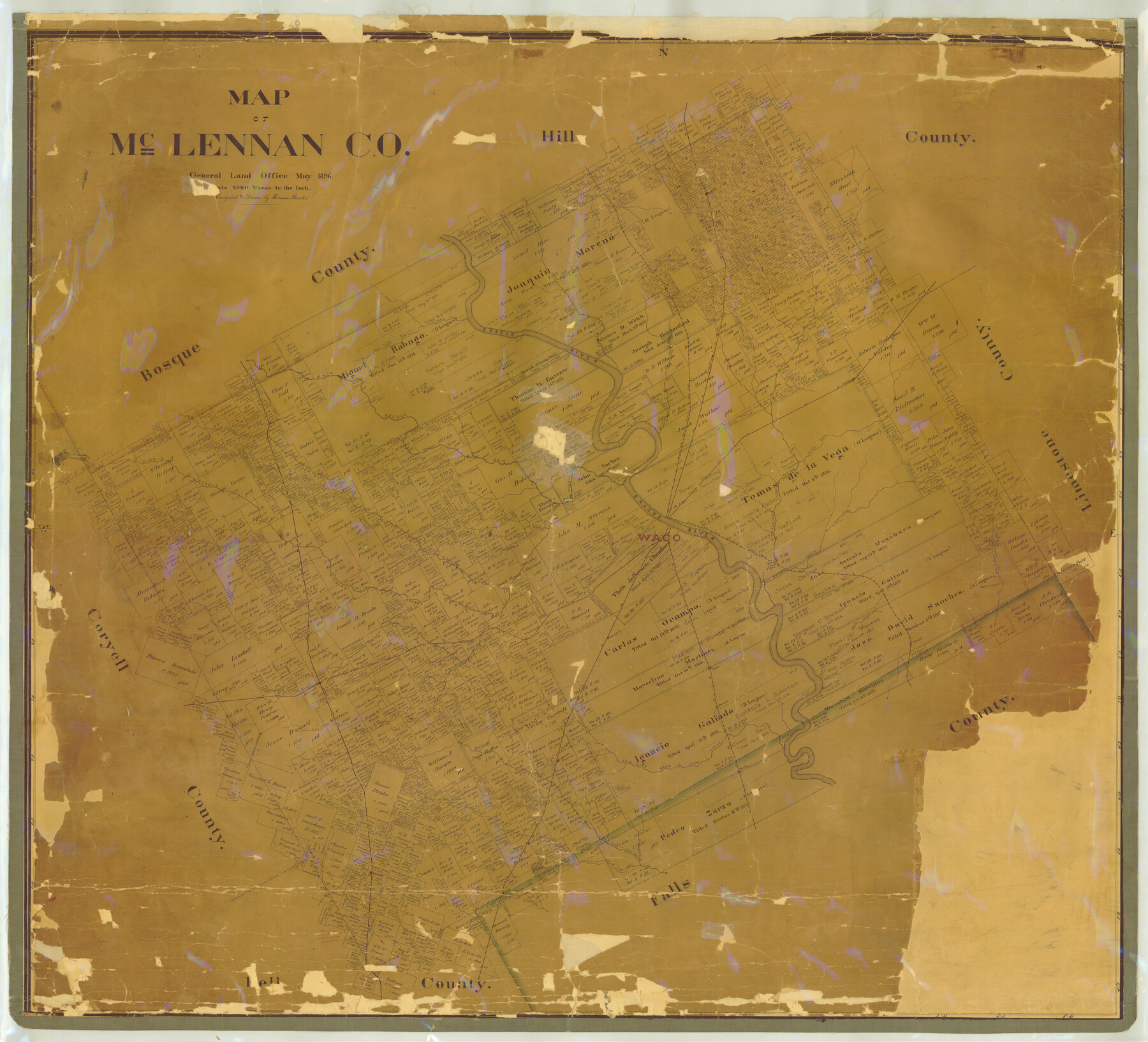
Map of McLennan County
-
Map/Doc
7952
-
Collection
General Map Collection
-
Object Dates
1896 (Creation Date)
-
People and Organizations
Texas General Land Office (Publisher)
Herman Pressler (Compiler)
Herman Pressler (Draftsman)
-
Counties
McLennan
-
Subjects
County
-
Height x Width
48.8 x 53.7 inches
124.0 x 136.4 cm
-
Comments
Help Save Texas History - Adopt Me!
-
Features
Crawford
Hewitt
Downs
Manas Creek
Turtle Bayou
Riesel
Big Creek
Harrison
Shaw's Creek
Sheep-Range Creek
Bluff Creek
Waco
Trading-House Creek
South Fork of Tehuacana Creek
Tehuacana Creek
W&NW
Farr
Patton
Moody
McGregor
Hoolie Br[anch]
Eddy
Cottonwood Creek
Cow Bayou
North Fork of Cow Bayou
South Fork of Cow Bayou
Bruceville
Middle Bosque River
Corrset County Line
Lorena
Gurly
Lake Creek
Bull Hide Bear Creek
Norwood
South Bosque River
Bull Hide Creek
Gholson
Brazos River
Childress Creek
North Fork of Childress Creek
South Fork of Childress Creek
West
Bruceville
Bear Creek
Aquila
Bluff Creek
Crawford
Waco Creek
Big Creek
China Springs
Axtell
Cottonwood Creek
Aquila Creek
Gerald
Hog Creek
Bosque River
Main Bosque River
China Springs
Patrick
Otter Creek
Axtell
Cottonwood Creek
Brazos River
GC&SF
H&TC
SL&SW
MK&T
Geneva
White Oak Creek
Ross
Part of: General Map Collection
Liberty County Working Sketch 7

Print $20.00
- Digital $50.00
Liberty County Working Sketch 7
1906
Size 22.2 x 24.8 inches
Map/Doc 70466
Houston County Working Sketch 11

Print $20.00
- Digital $50.00
Houston County Working Sketch 11
1953
Size 28.5 x 24.5 inches
Map/Doc 66241
Irion County Rolled Sketch 16

Print $20.00
- Digital $50.00
Irion County Rolled Sketch 16
1952
Size 24.4 x 41.6 inches
Map/Doc 6325
PSL Field Notes for Block C41 in Dawson, Lynn, and Terry Counties, Block C42 in Lynn and Terry Counties, and Blocks C40 and D23 in Lynn County

PSL Field Notes for Block C41 in Dawson, Lynn, and Terry Counties, Block C42 in Lynn and Terry Counties, and Blocks C40 and D23 in Lynn County
Map/Doc 81668
San Patricio County Rolled Sketch 38A

Print $20.00
- Digital $50.00
San Patricio County Rolled Sketch 38A
1958
Size 26.6 x 23.5 inches
Map/Doc 7589
Dickens County Rolled Sketch P

Print $20.00
- Digital $50.00
Dickens County Rolled Sketch P
1917
Size 41.2 x 36.9 inches
Map/Doc 8782
Austin County Working Sketch 8

Print $20.00
- Digital $50.00
Austin County Working Sketch 8
1992
Size 28.7 x 31.6 inches
Map/Doc 67249
Palo Pinto County

Print $40.00
- Digital $50.00
Palo Pinto County
1941
Size 49.4 x 40.4 inches
Map/Doc 95606
Culberson County Working Sketch 28

Print $40.00
- Digital $50.00
Culberson County Working Sketch 28
1952
Size 51.3 x 38.9 inches
Map/Doc 68481
Hockley County

Print $20.00
- Digital $50.00
Hockley County
1900
Size 41.5 x 36.7 inches
Map/Doc 16852
Live Oak County Boundary File 1

Print $24.00
- Digital $50.00
Live Oak County Boundary File 1
Size 9.0 x 4.2 inches
Map/Doc 56387
Flight Mission No. DCL-7C, Frame 75, Kenedy County

Print $20.00
- Digital $50.00
Flight Mission No. DCL-7C, Frame 75, Kenedy County
1943
Size 15.3 x 15.2 inches
Map/Doc 86061
You may also like
Val Verde County Working Sketch 98

Print $20.00
- Digital $50.00
Val Verde County Working Sketch 98
1980
Size 26.5 x 31.8 inches
Map/Doc 72233
Flight Mission No. DQN-1K, Frame 50, Calhoun County

Print $20.00
- Digital $50.00
Flight Mission No. DQN-1K, Frame 50, Calhoun County
1953
Size 18.7 x 22.3 inches
Map/Doc 84150
Map of Robertson County

Print $20.00
- Digital $50.00
Map of Robertson County
1863
Size 25.6 x 20.7 inches
Map/Doc 3997
Map of Terry County

Print $20.00
- Digital $50.00
Map of Terry County
1902
Size 45.6 x 40.8 inches
Map/Doc 16893
Carte de la Nouvelle France ou le voit le cours des Grandes Rivieres de S. Laurens & de Mississipi

Print $20.00
- Digital $50.00
Carte de la Nouvelle France ou le voit le cours des Grandes Rivieres de S. Laurens & de Mississipi
1720
Size 25.9 x 41.5 inches
Map/Doc 93822
McMullen County Rolled Sketch 20

Print $20.00
- Digital $50.00
McMullen County Rolled Sketch 20
Size 27.7 x 21.7 inches
Map/Doc 6736
Controlled Mosaic by Jack Amman Photogrammetric Engineers, Inc - Sheet 47

Print $20.00
- Digital $50.00
Controlled Mosaic by Jack Amman Photogrammetric Engineers, Inc - Sheet 47
1954
Size 20.0 x 24.0 inches
Map/Doc 83506
Wichita County Working Sketch 24

Print $20.00
- Digital $50.00
Wichita County Working Sketch 24
1971
Size 21.2 x 16.2 inches
Map/Doc 72534
Sutton County Rolled Sketch 71

Print $20.00
- Digital $50.00
Sutton County Rolled Sketch 71
Size 23.1 x 35.3 inches
Map/Doc 83760
Map of Giddings

Print $20.00
- Digital $50.00
Map of Giddings
1940
Size 16.5 x 21.2 inches
Map/Doc 2210
Brewster County Sketch File NS-4b

Print $40.00
- Digital $50.00
Brewster County Sketch File NS-4b
Size 30.4 x 35.8 inches
Map/Doc 10988
Hays County Boundary File

Print $120.00
- Digital $50.00
Hays County Boundary File
1947
Size 33.6 x 20.8 inches
Map/Doc 65496