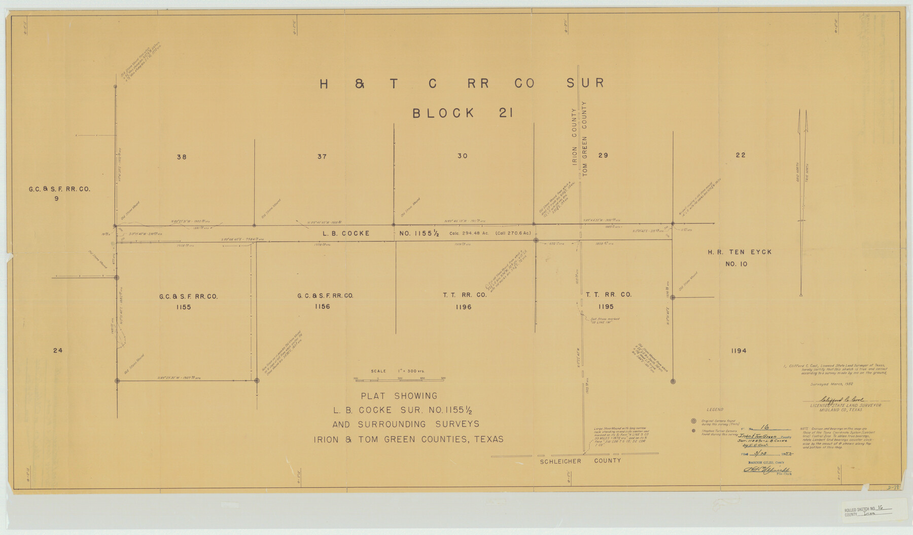
Irion County Rolled Sketch 16
Plat showing L.B. Cocke sur. no. 1155 1/2 and surrounding surveys Irion & Tom Green Counties, Texas
-
Map/Doc
6325
-
Collection
General Map Collection
-
Object Dates
1952 (Creation Date)
1952/3/28 (File Date)
-
People and Organizations
Clifford C. Cool (Surveyor/Engineer)
-
Counties
Irion Tom Green
-
Subjects
Surveying Rolled Sketch
-
Height x Width
24.4 x 41.6 inches
62.0 x 105.7 cm
-
Medium
blueprint/diazo
-
Scale
1" = 300 varas
Part of: General Map Collection
Grayson County Sketch File 5

Print $40.00
- Digital $50.00
Grayson County Sketch File 5
1856
Size 13.9 x 14.5 inches
Map/Doc 24464
Dawson County Sketch File 3

Print $20.00
- Digital $50.00
Dawson County Sketch File 3
Size 13.5 x 37.8 inches
Map/Doc 11290
Flight Mission No. CUG-3P, Frame 136, Kleberg County

Print $20.00
- Digital $50.00
Flight Mission No. CUG-3P, Frame 136, Kleberg County
1956
Size 18.5 x 22.3 inches
Map/Doc 86271
Bosque County Working Sketch 21

Print $40.00
- Digital $50.00
Bosque County Working Sketch 21
1984
Size 38.5 x 55.1 inches
Map/Doc 67454
Crockett County Sketch File 96

Print $4.00
- Digital $50.00
Crockett County Sketch File 96
1934
Size 11.4 x 8.9 inches
Map/Doc 19964
Flight Mission No. DQN-6K, Frame 69, Calhoun County

Print $20.00
- Digital $50.00
Flight Mission No. DQN-6K, Frame 69, Calhoun County
1953
Size 18.6 x 22.1 inches
Map/Doc 84441
San Patricio County Sketch File 35

Print $16.00
- Digital $50.00
San Patricio County Sketch File 35
1917
Size 14.5 x 8.8 inches
Map/Doc 36121
Terry County Rolled Sketch 7

Print $20.00
- Digital $50.00
Terry County Rolled Sketch 7
1903
Size 19.6 x 19.9 inches
Map/Doc 7981
Hardin County Sketch File 30

Print $6.00
- Digital $50.00
Hardin County Sketch File 30
Size 6.5 x 8.1 inches
Map/Doc 25157
Val Verde County Rolled Sketch JR

Print $20.00
- Digital $50.00
Val Verde County Rolled Sketch JR
1938
Size 35.9 x 31.1 inches
Map/Doc 10080
Galveston County Boundary File 32

Print $52.00
- Digital $50.00
Galveston County Boundary File 32
Size 16.7 x 13.6 inches
Map/Doc 53658
Archer County Sketch File 3

Print $4.00
- Digital $50.00
Archer County Sketch File 3
Size 7.5 x 8.5 inches
Map/Doc 13628
You may also like
Flight Mission No. BRA-9M, Frame 61, Jefferson County

Print $20.00
- Digital $50.00
Flight Mission No. BRA-9M, Frame 61, Jefferson County
1953
Size 18.7 x 22.4 inches
Map/Doc 85644
Falls County Sketch File 11b

Print $4.00
- Digital $50.00
Falls County Sketch File 11b
1871
Size 10.4 x 8.5 inches
Map/Doc 22362
Galveston County NRC Article 33.136 Sketch 25

Print $26.00
- Digital $50.00
Galveston County NRC Article 33.136 Sketch 25
1999
Size 36.0 x 23.9 inches
Map/Doc 81906

Southern Part of Laguna Madre

Print $20.00
- Digital $50.00
Southern Part of Laguna Madre
1946
Size 43.8 x 34.5 inches
Map/Doc 73534
Grayson County Working Sketch 11

Print $20.00
- Digital $50.00
Grayson County Working Sketch 11
1951
Size 27.9 x 24.3 inches
Map/Doc 63250
[Lamb County Sketch File C]
![91193, [Lamb County Sketch File C], Twichell Survey Records](https://historictexasmaps.com/wmedia_w700/maps/91193-1.tif.jpg)
Print $20.00
- Digital $50.00
[Lamb County Sketch File C]
1904
Size 20.1 x 27.2 inches
Map/Doc 91193
Coke County Rolled Sketch 3

Print $20.00
- Digital $50.00
Coke County Rolled Sketch 3
1947
Size 40.6 x 40.3 inches
Map/Doc 8623
Brown County Sketch File 10a

Print $6.00
- Digital $50.00
Brown County Sketch File 10a
Size 11.2 x 9.8 inches
Map/Doc 16595
Brazoria County Working Sketch 21

Print $20.00
- Digital $50.00
Brazoria County Working Sketch 21
1954
Size 41.5 x 41.8 inches
Map/Doc 67506
Crosby County Working Sketch 4

Print $20.00
- Digital $50.00
Crosby County Working Sketch 4
1907
Size 19.9 x 14.0 inches
Map/Doc 68438
Soil Map, Texas, Titus County Sheet

Print $20.00
- Digital $50.00
Soil Map, Texas, Titus County Sheet
1909
Size 30.5 x 22.4 inches
Map/Doc 3080