San Patricio County Sketch File 35
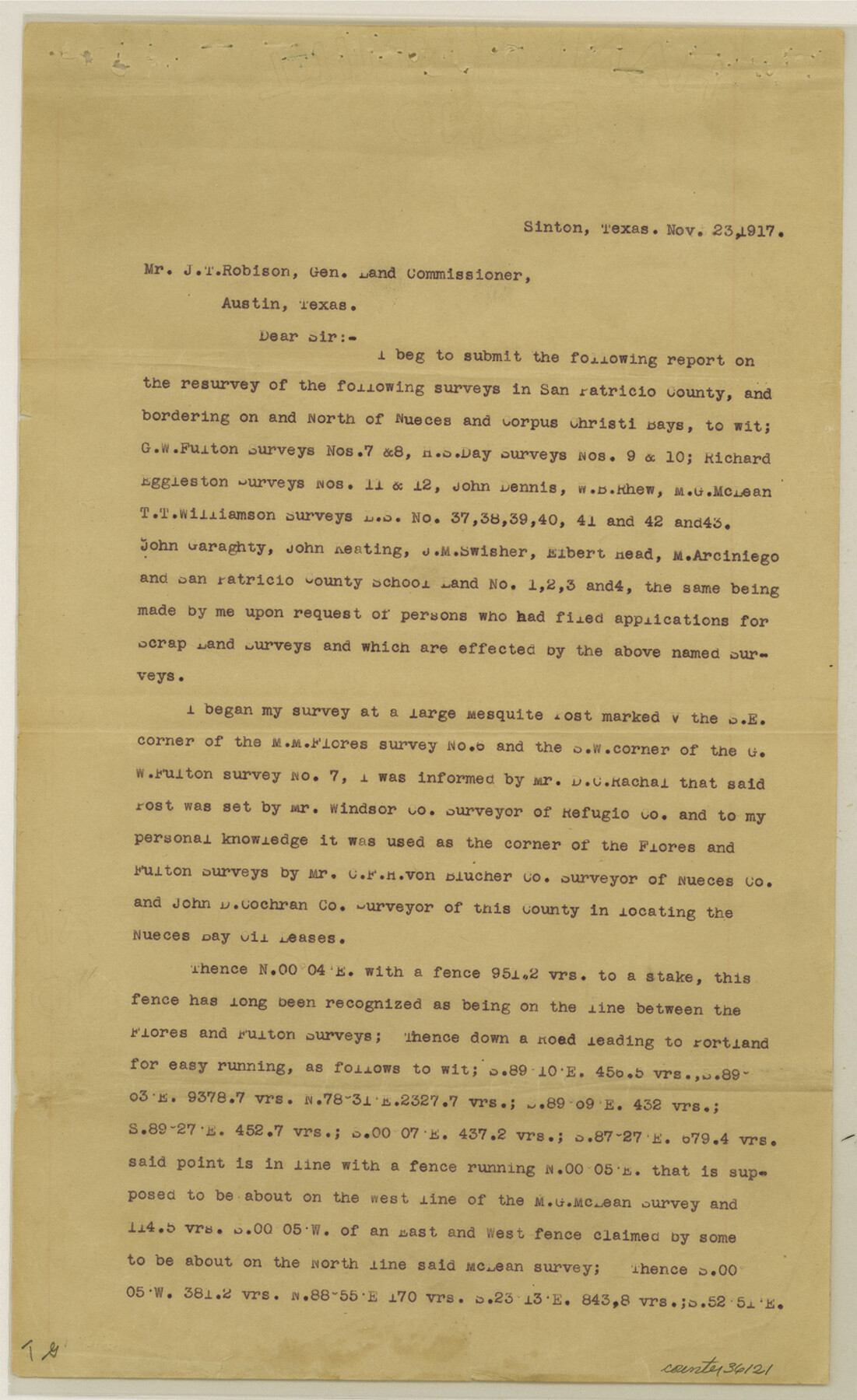
[Report of resurvey of the following surveys situated in San Patricio County, Texas: G.W. Fulton, H.S. Day, R. Eggleston, John Dennis, W.B. Rhew, M.G. McLean, T.T. Williamson, and more north of Nueces and Corpus Christi Bays]
-
Map/Doc
36121
-
Collection
General Map Collection
-
Object Dates
11/23/1917 (Creation Date)
10/2/1963 (File Date)
-
People and Organizations
H.A. Peabody (Surveyor/Engineer)
-
Counties
San Patricio
-
Subjects
Surveying Sketch File
-
Height x Width
14.5 x 8.8 inches
36.8 x 22.4 cm
-
Medium
paper, print
-
Comments
See San Patricio County Rolled Sketch 40 (7726) for sketch.
-
Features
Nueces Bay
Corpus Christi Bay
Portland
McGloin Bluff
Indian Point
SA&AP
Related maps
San Patricio County Rolled Sketch 40

Print $20.00
- Digital $50.00
San Patricio County Rolled Sketch 40
1917
Size 26.0 x 36.0 inches
Map/Doc 7726
Part of: General Map Collection
Flight Mission No. BRA-7M, Frame 193, Jefferson County

Print $20.00
- Digital $50.00
Flight Mission No. BRA-7M, Frame 193, Jefferson County
1953
Size 18.7 x 22.4 inches
Map/Doc 85561
Knox County Sketch File 22

Print $6.00
- Digital $50.00
Knox County Sketch File 22
1931
Size 11.2 x 8.8 inches
Map/Doc 29251
Flight Mission No. DAG-23K, Frame 172, Matagorda County

Print $20.00
- Digital $50.00
Flight Mission No. DAG-23K, Frame 172, Matagorda County
1953
Size 18.6 x 16.0 inches
Map/Doc 86510

Floyd County Working Sketch 9

Print $20.00
- Digital $50.00
Floyd County Working Sketch 9
1952
Size 31.5 x 35.9 inches
Map/Doc 69188
Cameron County Rolled Sketch 29

Print $20.00
- Digital $50.00
Cameron County Rolled Sketch 29
1990
Size 29.3 x 46.4 inches
Map/Doc 8578
Traced from Genl. Arista's map captured by the American Army under Genl. Taylor at Resaca de la Palma 9th May '46 and presented to James K. Polk, President U. States

Print $20.00
- Digital $50.00
Traced from Genl. Arista's map captured by the American Army under Genl. Taylor at Resaca de la Palma 9th May '46 and presented to James K. Polk, President U. States
1846
Size 18.2 x 27.3 inches
Map/Doc 73060
University Land Field Notes for Blocks 29 through 33, Crockett County

University Land Field Notes for Blocks 29 through 33, Crockett County
Map/Doc 81715
Newton County Working Sketch 34

Print $20.00
- Digital $50.00
Newton County Working Sketch 34
1959
Size 27.0 x 32.6 inches
Map/Doc 71280
Bee County Sketch File 29

Print $6.00
- Digital $50.00
Bee County Sketch File 29
1887
Size 14.0 x 8.8 inches
Map/Doc 14338
Garza County Rolled Sketch 11 & 11A

Print $31.00
- Digital $50.00
Garza County Rolled Sketch 11 & 11A
1915
Size 10.3 x 15.5 inches
Map/Doc 45214
[Galveston, Harrisburg & San Antonio Railroad from Cuero to Stockdale]
![64196, [Galveston, Harrisburg & San Antonio Railroad from Cuero to Stockdale], General Map Collection](https://historictexasmaps.com/wmedia_w700/maps/64196.tif.jpg)
Print $20.00
- Digital $50.00
[Galveston, Harrisburg & San Antonio Railroad from Cuero to Stockdale]
1907
Size 13.7 x 34.0 inches
Map/Doc 64196
You may also like
Sulphur River and Cuthand Creek, Hardison Lake Sheet

Print $20.00
- Digital $50.00
Sulphur River and Cuthand Creek, Hardison Lake Sheet
1919
Size 13.4 x 18.0 inches
Map/Doc 78327
Wichita County Working Sketch 24

Print $20.00
- Digital $50.00
Wichita County Working Sketch 24
1971
Size 21.2 x 16.2 inches
Map/Doc 72534
Atascosa County Working Sketch 33

Print $20.00
- Digital $50.00
Atascosa County Working Sketch 33
1982
Size 16.7 x 13.6 inches
Map/Doc 67229
Acts of the Visit of the Royal Commissioners (sometimes referred to as the “Visita General”) - Revilla [Guerrero]

Acts of the Visit of the Royal Commissioners (sometimes referred to as the “Visita General”) - Revilla [Guerrero]
1767
Size 14.1 x 9.5 inches
Map/Doc 94255
[Part of Blocks 34 and 35, Township 3 North]
![91287, [Part of Blocks 34 and 35, Township 3 North], Twichell Survey Records](https://historictexasmaps.com/wmedia_w700/maps/91287-1.tif.jpg)
Print $20.00
- Digital $50.00
[Part of Blocks 34 and 35, Township 3 North]
Size 12.7 x 13.5 inches
Map/Doc 91287
Borden County

Print $20.00
- Digital $50.00
Borden County
1922
Size 36.8 x 41.7 inches
Map/Doc 92457
[Gunter & Munson, Maddox Bros. & Anderson Block F] / [PSL Block B19]
![91849, [Gunter & Munson, Maddox Bros. & Anderson Block F] / [PSL Block B19], Twichell Survey Records](https://historictexasmaps.com/wmedia_w700/maps/91849-1.tif.jpg)
Print $20.00
- Digital $50.00
[Gunter & Munson, Maddox Bros. & Anderson Block F] / [PSL Block B19]
Size 18.6 x 22.0 inches
Map/Doc 91849
Polk County Rolled Sketch 27

Print $20.00
- Digital $50.00
Polk County Rolled Sketch 27
1944
Size 21.1 x 26.6 inches
Map/Doc 7315
Garza County Rolled Sketch 12

Print $20.00
- Digital $50.00
Garza County Rolled Sketch 12
1916
Size 31.5 x 26.0 inches
Map/Doc 6069
Bastrop County Rolled Sketch 1A

Print $20.00
- Digital $50.00
Bastrop County Rolled Sketch 1A
Size 37.0 x 24.5 inches
Map/Doc 5122
Guadalupe County Sketch File 26

Print $4.00
- Digital $50.00
Guadalupe County Sketch File 26
1873
Size 10.2 x 8.2 inches
Map/Doc 24719
Young County Working Sketch 1

Print $20.00
- Digital $50.00
Young County Working Sketch 1
1960
Size 31.1 x 41.9 inches
Map/Doc 62024