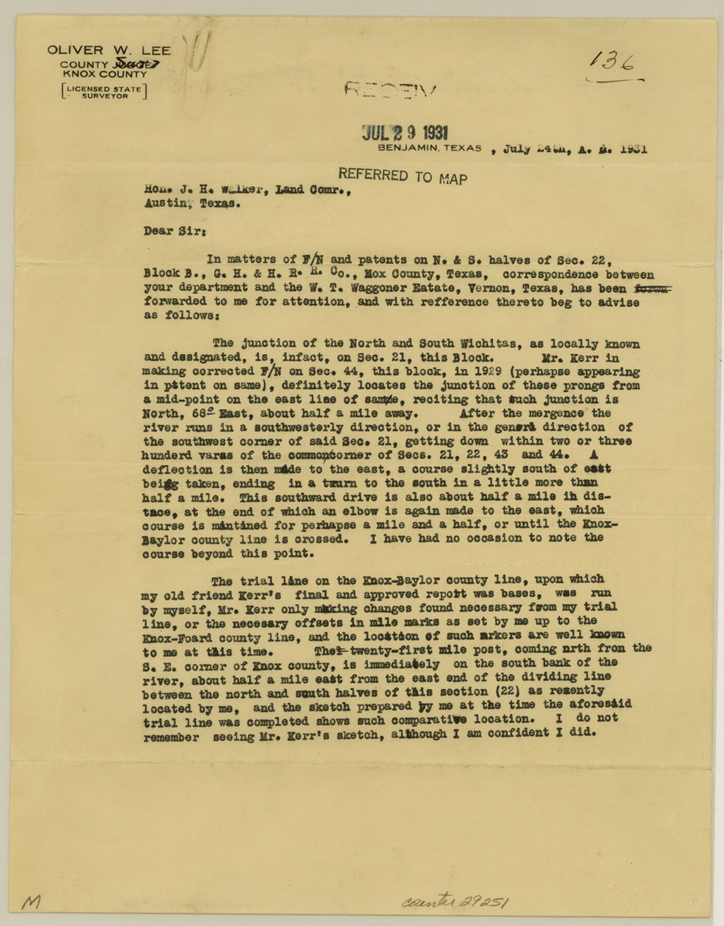
Knox County Sketch File 22
[Surveyor's statement regarding section 22, Block B, G. H. & H. Ry. Co.]
-
Map/Doc
29251
-
Collection
General Map Collection
-
Object Dates
7/24/1931 (Creation Date)
7/29/1931 (File Date)
-
People and Organizations
Oliver W. Lee (Surveyor/Engineer)
-
Counties
Knox
-
Subjects
Surveying Sketch File
-
Height x Width
11.2 x 8.8 inches
28.5 x 22.4 cm
-
Medium
paper, print
-
Features
North Wichita River
South Wichita River
Part of: General Map Collection
Stonewall County Sketch File 15

Print $40.00
- Digital $50.00
Stonewall County Sketch File 15
1905
Size 14.3 x 8.7 inches
Map/Doc 37255
Burnet County Sketch File 14

Print $4.00
- Digital $50.00
Burnet County Sketch File 14
Size 15.1 x 8.9 inches
Map/Doc 16698
Jeff Davis County Sketch File 41

Print $40.00
- Digital $50.00
Jeff Davis County Sketch File 41
1959
Size 13.3 x 13.4 inches
Map/Doc 28064
Marion County Working Sketch 6

Print $20.00
- Digital $50.00
Marion County Working Sketch 6
1962
Size 33.7 x 19.8 inches
Map/Doc 70781
Coleman County Working Sketch Graphic Index

Print $40.00
- Digital $50.00
Coleman County Working Sketch Graphic Index
1945
Size 54.0 x 36.3 inches
Map/Doc 76497
Crosby County Working Sketch 4

Print $20.00
- Digital $50.00
Crosby County Working Sketch 4
1907
Size 19.9 x 14.0 inches
Map/Doc 68438
Dimmit County Working Sketch 36

Print $20.00
- Digital $50.00
Dimmit County Working Sketch 36
1962
Size 28.0 x 40.7 inches
Map/Doc 68697
Flight Mission No. CGI-3N, Frame 50, Cameron County

Print $20.00
- Digital $50.00
Flight Mission No. CGI-3N, Frame 50, Cameron County
1954
Size 18.6 x 22.2 inches
Map/Doc 84556
Presidio County Working Sketch 84

Print $20.00
- Digital $50.00
Presidio County Working Sketch 84
1970
Size 20.7 x 17.8 inches
Map/Doc 71761
Current Miscellaneous File 19

Print $10.00
- Digital $50.00
Current Miscellaneous File 19
Size 11.8 x 8.8 inches
Map/Doc 73849
Leon County Working Sketch 15

Print $20.00
- Digital $50.00
Leon County Working Sketch 15
1958
Size 27.3 x 26.7 inches
Map/Doc 70414
Jack County Working Sketch 5

Print $20.00
- Digital $50.00
Jack County Working Sketch 5
1952
Size 25.7 x 22.1 inches
Map/Doc 66431
You may also like
General Highway Map, San Patricio County, Texas

Print $20.00
General Highway Map, San Patricio County, Texas
1961
Size 18.1 x 24.5 inches
Map/Doc 79647
Pecos County Rolled Sketch 46

Print $3.00
- Digital $50.00
Pecos County Rolled Sketch 46
1913
Size 13.4 x 9.7 inches
Map/Doc 7224
Coke County Boundary File 2

Print $64.00
- Digital $50.00
Coke County Boundary File 2
Size 49.0 x 9.0 inches
Map/Doc 51580
Reeves County Rolled Sketch 35

Print $20.00
- Digital $50.00
Reeves County Rolled Sketch 35
2013
Size 25.3 x 36.8 inches
Map/Doc 93706
Reeves County Rolled Sketch 30

Print $20.00
- Digital $50.00
Reeves County Rolled Sketch 30
1988
Size 18.4 x 24.4 inches
Map/Doc 7499
Ft. W. & R. G. Ry. Right of Way Map, Chapin to Bluffdale, Hood County, Texas

Print $40.00
- Digital $50.00
Ft. W. & R. G. Ry. Right of Way Map, Chapin to Bluffdale, Hood County, Texas
1918
Size 37.3 x 120.2 inches
Map/Doc 64642
Bandera County Rolled Sketch 9

Print $20.00
- Digital $50.00
Bandera County Rolled Sketch 9
Size 21.2 x 24.2 inches
Map/Doc 5120
Hudspeth County Rolled Sketch 44

Print $20.00
- Digital $50.00
Hudspeth County Rolled Sketch 44
1951
Size 12.1 x 11.5 inches
Map/Doc 9217
Flight Mission No. DAG-16K, Frame 72, Matagorda County

Print $20.00
- Digital $50.00
Flight Mission No. DAG-16K, Frame 72, Matagorda County
1952
Size 16.5 x 16.4 inches
Map/Doc 86318
[Brown County]
![3337, [Brown County], General Map Collection](https://historictexasmaps.com/wmedia_w700/maps/3337-1.tif.jpg)
Print $20.00
- Digital $50.00
[Brown County]
1863
Size 25.4 x 22.5 inches
Map/Doc 3337
Edwards County Sketch File 19

Print $20.00
- Digital $50.00
Edwards County Sketch File 19
Size 17.1 x 23.7 inches
Map/Doc 11430
Bandera County Working Sketch 60

Print $20.00
- Digital $50.00
Bandera County Working Sketch 60
2004
Size 32.1 x 43.6 inches
Map/Doc 83562