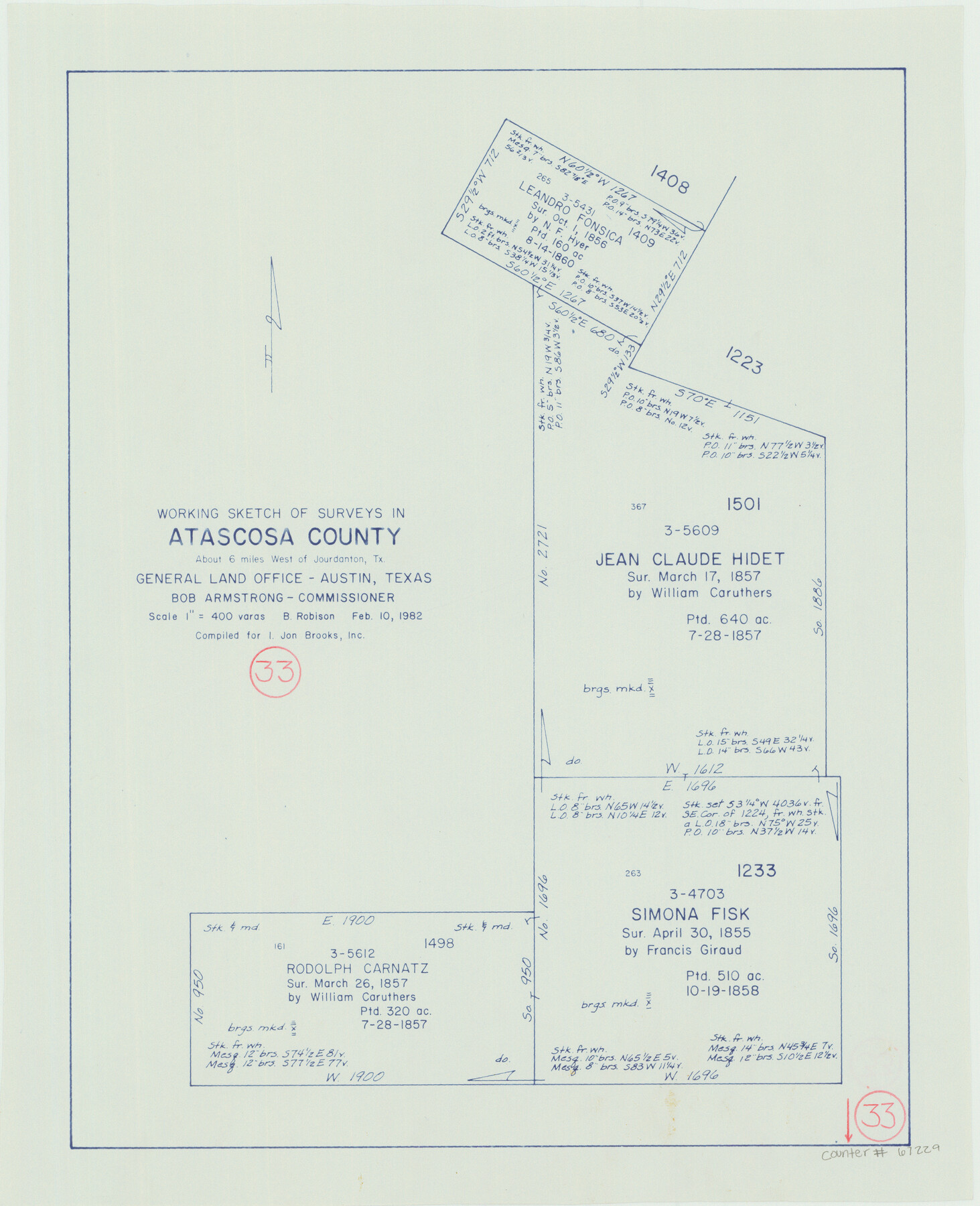
Atascosa County Working Sketch 33
-
Map/Doc
67229
-
Collection
General Map Collection
-
Object Dates
2/10/1982 (Creation Date)
-
People and Organizations
Beverly Robison (Draftsman)
Bob Armstrong (GLO Commissioner)
-
Counties
Atascosa
-
Subjects
Surveying Working Sketch
-
Height x Width
16.7 x 13.6 inches
42.4 x 34.5 cm
-
Scale
1" = 400 varas
-
Comments
Surveys located about six miles West of Jourdanton, Texas.
Part of: General Map Collection
Reeves County Working Sketch 5

Print $20.00
- Digital $50.00
Reeves County Working Sketch 5
1938
Size 38.0 x 32.4 inches
Map/Doc 63448
Cottle County Rolled Sketch 11

Print $20.00
- Digital $50.00
Cottle County Rolled Sketch 11
1927
Size 31.6 x 24.1 inches
Map/Doc 5568
Scurry County Working Sketch 4
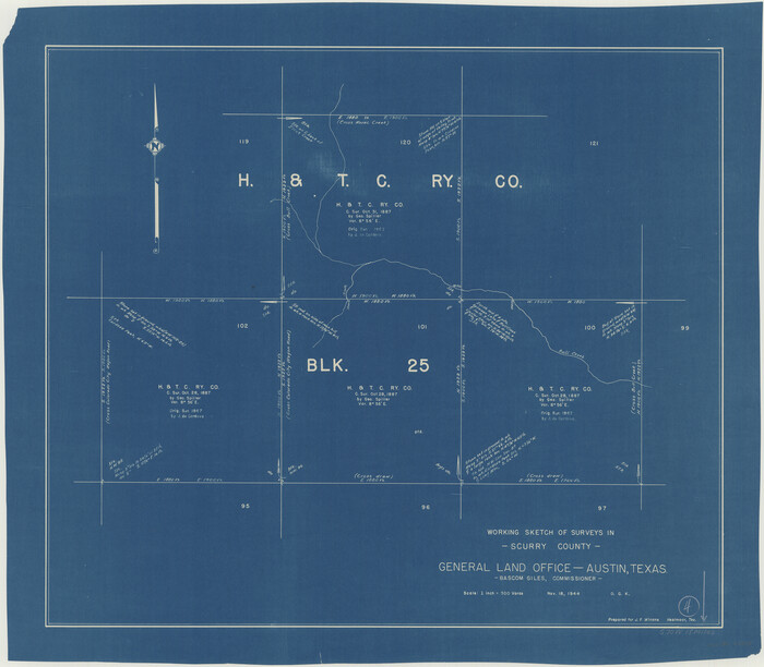
Print $20.00
- Digital $50.00
Scurry County Working Sketch 4
1944
Size 23.1 x 26.5 inches
Map/Doc 63833
Tyler County Sketch File 28

Print $46.00
- Digital $50.00
Tyler County Sketch File 28
1960
Size 9.8 x 8.6 inches
Map/Doc 38699
Stonewall County Rolled Sketch 28

Print $20.00
- Digital $50.00
Stonewall County Rolled Sketch 28
Size 42.8 x 46.5 inches
Map/Doc 9967
Map of Washington County

Print $20.00
- Digital $50.00
Map of Washington County
1841
Size 28.5 x 29.0 inches
Map/Doc 4122
Presidio County Rolled Sketch 104

Print $20.00
- Digital $50.00
Presidio County Rolled Sketch 104
1948
Size 26.1 x 40.0 inches
Map/Doc 7386
Upton County Working Sketch 55

Print $20.00
- Digital $50.00
Upton County Working Sketch 55
Size 25.7 x 36.7 inches
Map/Doc 69552
Maps & Lists Showing Prison Lands (Oil & Gas) Leased as of June 1955

Digital $50.00
Maps & Lists Showing Prison Lands (Oil & Gas) Leased as of June 1955
1934
Size 19.1 x 38.7 inches
Map/Doc 62878
Erath County Working Sketch 36

Print $20.00
- Digital $50.00
Erath County Working Sketch 36
1973
Size 33.5 x 30.4 inches
Map/Doc 69117
Galveston / Texas City, Texas Street Map

Galveston / Texas City, Texas Street Map
2000
Size 36.1 x 24.2 inches
Map/Doc 96855
Flight Mission No. DQN-6K, Frame 15, Calhoun County

Print $20.00
- Digital $50.00
Flight Mission No. DQN-6K, Frame 15, Calhoun County
1953
Size 18.4 x 22.2 inches
Map/Doc 84437
You may also like
Kaufman County Working Sketch 5

Print $20.00
- Digital $50.00
Kaufman County Working Sketch 5
1922
Size 31.8 x 46.0 inches
Map/Doc 66668
Caddo Lake Subdivision, Copied from Sketch in MF 000964

Print $20.00
- Digital $50.00
Caddo Lake Subdivision, Copied from Sketch in MF 000964
1918
Size 32.5 x 28.0 inches
Map/Doc 1929
Comal County Rolled Sketch 5

Print $20.00
- Digital $50.00
Comal County Rolled Sketch 5
1985
Size 30.6 x 26.7 inches
Map/Doc 5540
Jefferson County Working Sketch 28

Print $20.00
- Digital $50.00
Jefferson County Working Sketch 28
1977
Size 46.2 x 42.9 inches
Map/Doc 66571

Matagorda Bay and Approaches

Print $20.00
- Digital $50.00
Matagorda Bay and Approaches
1961
Size 35.0 x 45.0 inches
Map/Doc 73382
Eastland County Working Sketch 20

Print $20.00
- Digital $50.00
Eastland County Working Sketch 20
1920
Size 38.0 x 23.5 inches
Map/Doc 68801
Public Land on Mustang Island, Nueces County

Print $20.00
- Digital $50.00
Public Land on Mustang Island, Nueces County
1910
Size 17.0 x 17.5 inches
Map/Doc 93362
Crockett County Rolled Sketch 29

Print $20.00
- Digital $50.00
Crockett County Rolled Sketch 29
1927
Size 21.9 x 36.6 inches
Map/Doc 5588
[Sections 61-65, I. & G. N. Block 1 and part of Block 194]
![91678, [Sections 61-65, I. & G. N. Block 1 and part of Block 194], Twichell Survey Records](https://historictexasmaps.com/wmedia_w700/maps/91678-1.tif.jpg)
Print $20.00
- Digital $50.00
[Sections 61-65, I. & G. N. Block 1 and part of Block 194]
Size 24.9 x 17.3 inches
Map/Doc 91678
[Panhandle Counties]
![92066, [Panhandle Counties], Twichell Survey Records](https://historictexasmaps.com/wmedia_w700/maps/92066-1.tif.jpg)
Print $2.00
- Digital $50.00
[Panhandle Counties]
1885
Size 12.6 x 8.9 inches
Map/Doc 92066
Glasscock County Sketch File 19

Print $20.00
- Digital $50.00
Glasscock County Sketch File 19
Size 21.4 x 16.8 inches
Map/Doc 11563