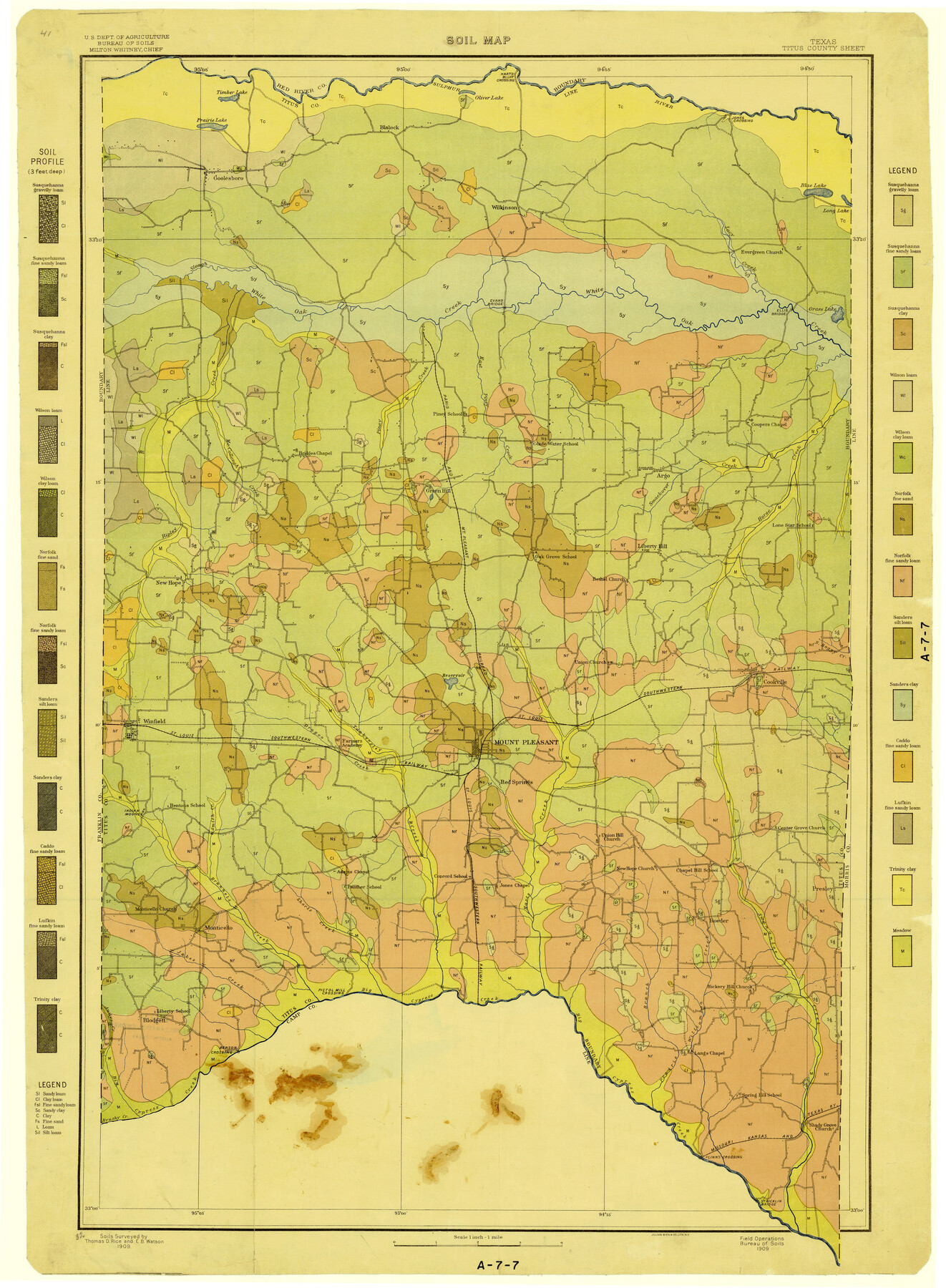
Soil Map, Texas, Titus County Sheet
A-7-7
-
Map/Doc
3080
-
Collection
General Map Collection
-
Object Dates
1909 (Creation Date)
-
People and Organizations
Thomas D. Rice (Surveyor/Engineer)
E.B. Watson (Surveyor/Engineer)
U.S. Department of Agriculture (Author)
-
Counties
Titus
-
Subjects
County
-
Height x Width
30.5 x 22.4 inches
77.5 x 56.9 cm
Part of: General Map Collection
Galveston County Sketch File 26

Print $4.00
- Digital $50.00
Galveston County Sketch File 26
1860
Size 11.8 x 5.7 inches
Map/Doc 23397
El Paso County Boundary File 18

Print $21.00
- Digital $50.00
El Paso County Boundary File 18
Size 13.7 x 8.5 inches
Map/Doc 53196
Edwards County Sketch File 36

Print $20.00
- Digital $50.00
Edwards County Sketch File 36
Size 18.3 x 18.7 inches
Map/Doc 11436
Ashburn's 1951 Austin City Map

Ashburn's 1951 Austin City Map
1951
Size 22.5 x 17.4 inches
Map/Doc 97142
Map of Hardeman Co., Texas

Print $20.00
- Digital $50.00
Map of Hardeman Co., Texas
1903
Size 36.8 x 25.6 inches
Map/Doc 4559
Briscoe County Working Sketch 4

Print $20.00
- Digital $50.00
Briscoe County Working Sketch 4
1919
Size 26.6 x 22.7 inches
Map/Doc 67807
Donley County Boundary File 9

Print $50.00
- Digital $50.00
Donley County Boundary File 9
1903
Size 13.0 x 8.1 inches
Map/Doc 62233
Coleman County Working Sketch 22

Print $20.00
- Digital $50.00
Coleman County Working Sketch 22
1953
Size 34.6 x 41.0 inches
Map/Doc 68088
Wichita County Sketch File 3

Print $8.00
- Digital $50.00
Wichita County Sketch File 3
1856
Size 7.2 x 16.3 inches
Map/Doc 40033
Zavala County Boundary File 1

Print $48.00
- Digital $50.00
Zavala County Boundary File 1
Size 12.8 x 8.3 inches
Map/Doc 60233
Hamilton County Working Sketch 19

Print $20.00
- Digital $50.00
Hamilton County Working Sketch 19
1953
Size 45.7 x 23.4 inches
Map/Doc 63357
Trinity River, East Fork of Trinity River Levee Improvement Districts/Widths of Floodways as Established by Approved Plans

Print $4.00
- Digital $50.00
Trinity River, East Fork of Trinity River Levee Improvement Districts/Widths of Floodways as Established by Approved Plans
1919
Size 28.4 x 18.5 inches
Map/Doc 65248
You may also like
Flight Mission No. DCL-7C, Frame 72, Kenedy County

Print $20.00
- Digital $50.00
Flight Mission No. DCL-7C, Frame 72, Kenedy County
1943
Size 15.4 x 15.1 inches
Map/Doc 86058
Flight Mission No. BRE-1P, Frame 106, Nueces County

Print $20.00
- Digital $50.00
Flight Mission No. BRE-1P, Frame 106, Nueces County
1956
Size 18.6 x 22.6 inches
Map/Doc 86677
Angelina County Working Sketch 53

Print $40.00
- Digital $50.00
Angelina County Working Sketch 53
1988
Size 42.9 x 58.5 inches
Map/Doc 67137
[Surveys in the Bexar District along the Medina River]
![130, [Surveys in the Bexar District along the Medina River], General Map Collection](https://historictexasmaps.com/wmedia_w700/maps/130.tif.jpg)
Print $20.00
- Digital $50.00
[Surveys in the Bexar District along the Medina River]
1841
Size 20.7 x 12.8 inches
Map/Doc 130
Tarrant County Boundary File 82

Print $22.00
- Digital $50.00
Tarrant County Boundary File 82
Size 8.9 x 7.0 inches
Map/Doc 59173
Sterling County Sketch File 13

Print $20.00
- Digital $50.00
Sterling County Sketch File 13
Size 26.1 x 19.4 inches
Map/Doc 12359
Matagorda County Working Sketch 10

Print $20.00
- Digital $50.00
Matagorda County Working Sketch 10
1958
Size 27.8 x 33.3 inches
Map/Doc 70868
Menard County Sketch File 8

Print $20.00
- Digital $50.00
Menard County Sketch File 8
Size 19.7 x 28.5 inches
Map/Doc 12073
Zavala County Rolled Sketch 26

Print $20.00
- Digital $50.00
Zavala County Rolled Sketch 26
1952
Size 25.3 x 41.8 inches
Map/Doc 8328
San Jacinto County Working Sketch 37

Print $20.00
- Digital $50.00
San Jacinto County Working Sketch 37
1965
Size 32.7 x 42.6 inches
Map/Doc 63750
General Highway Map, Hardin County, Texas

Print $20.00
General Highway Map, Hardin County, Texas
1961
Size 18.1 x 24.9 inches
Map/Doc 79499
[Lgs. 209-212, 182, 183, 195-200 with notes]
![90158, [Lgs. 209-212, 182, 183, 195-200 with notes], Twichell Survey Records](https://historictexasmaps.com/wmedia_w700/maps/90158-1.tif.jpg)
Print $20.00
- Digital $50.00
[Lgs. 209-212, 182, 183, 195-200 with notes]
Size 17.0 x 15.8 inches
Map/Doc 90158