Sterling County Sketch File 13
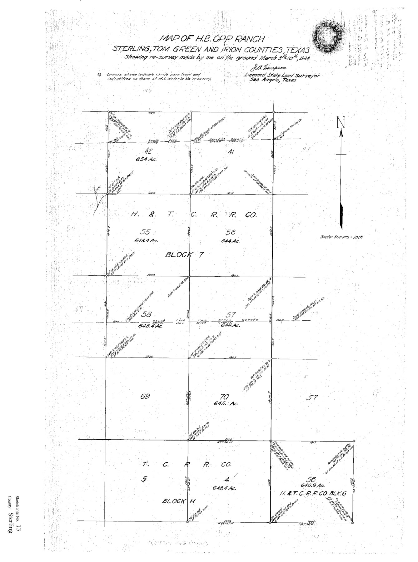
Map of H. B. Opp Ranch, Sterling, Tom Green & Irion Counties, Texas
-
Map/Doc
12359
-
Collection
General Map Collection
-
Object Dates
1934/3/24 (File Date)
1934/3/10 (Survey Date)
-
People and Organizations
J.A. Simpson (Surveyor/Engineer)
-
Counties
Sterling
-
Subjects
Surveying Sketch File
-
Height x Width
26.1 x 19.4 inches
66.3 x 49.3 cm
-
Medium
paper, print
-
Scale
1:500
Part of: General Map Collection
Flight Mission No. CGI-3N, Frame 70, Cameron County

Print $20.00
- Digital $50.00
Flight Mission No. CGI-3N, Frame 70, Cameron County
1954
Size 18.7 x 22.3 inches
Map/Doc 84564
Harris County Rolled Sketch GC

Print $40.00
- Digital $50.00
Harris County Rolled Sketch GC
1917
Size 42.1 x 52.4 inches
Map/Doc 9115
Map of Reeves County

Print $20.00
- Digital $50.00
Map of Reeves County
1892
Size 47.2 x 35.4 inches
Map/Doc 78401
Flight Mission No. DQO-11K, Frame 20, Galveston County

Print $20.00
- Digital $50.00
Flight Mission No. DQO-11K, Frame 20, Galveston County
1952
Size 18.8 x 22.4 inches
Map/Doc 85215
Map of Newton County

Print $40.00
- Digital $50.00
Map of Newton County
1894
Size 69.8 x 28.4 inches
Map/Doc 82078
Wharton County Sketch File 21

Print $40.00
- Digital $50.00
Wharton County Sketch File 21
1911
Size 14.8 x 13.0 inches
Map/Doc 39986
Flight Mission No. DCL-7C, Frame 65, Kenedy County

Print $20.00
- Digital $50.00
Flight Mission No. DCL-7C, Frame 65, Kenedy County
1943
Size 18.5 x 22.3 inches
Map/Doc 86051
Dimmit County Rolled Sketch 21

Print $20.00
- Digital $50.00
Dimmit County Rolled Sketch 21
2013
Size 25.5 x 22.5 inches
Map/Doc 93488
Hood County Rolled Sketch 3

Print $20.00
- Digital $50.00
Hood County Rolled Sketch 3
1967
Size 33.2 x 36.2 inches
Map/Doc 9179
Current Miscellaneous File 29

Print $10.00
- Digital $50.00
Current Miscellaneous File 29
Size 11.2 x 8.8 inches
Map/Doc 73920
[Surveys in the Bexar District along the Nueces River]
![84, [Surveys in the Bexar District along the Nueces River], General Map Collection](https://historictexasmaps.com/wmedia_w700/maps/84.tif.jpg)
Print $3.00
- Digital $50.00
[Surveys in the Bexar District along the Nueces River]
1847
Size 17.1 x 8.1 inches
Map/Doc 84
Controlled Mosaic by Jack Amman Photogrammetric Engineers, Inc - Sheet 57

Print $20.00
- Digital $50.00
Controlled Mosaic by Jack Amman Photogrammetric Engineers, Inc - Sheet 57
1954
Size 20.0 x 24.0 inches
Map/Doc 83516
You may also like
Flight Mission No. BQR-20K, Frame 10, Brazoria County

Print $20.00
- Digital $50.00
Flight Mission No. BQR-20K, Frame 10, Brazoria County
1952
Size 18.6 x 22.3 inches
Map/Doc 84112
Gregg County School Land League 2

Print $20.00
- Digital $50.00
Gregg County School Land League 2
Size 16.4 x 17.7 inches
Map/Doc 90614
Zavala Empresario Colony. March 12, 1829

Print $20.00
Zavala Empresario Colony. March 12, 1829
2020
Size 24.7 x 21.7 inches
Map/Doc 96012
San Antonio - Places of Interest and how to get there

San Antonio - Places of Interest and how to get there
1920
Map/Doc 96785
Plan of the City of Calhoun

Print $40.00
- Digital $50.00
Plan of the City of Calhoun
1839
Size 49.7 x 58.9 inches
Map/Doc 2175
Zapata County Working Sketch 10

Print $20.00
- Digital $50.00
Zapata County Working Sketch 10
1954
Size 33.9 x 32.2 inches
Map/Doc 62061
Calhoun County NRC Article 33.136 Location Key Sheet

Print $20.00
- Digital $50.00
Calhoun County NRC Article 33.136 Location Key Sheet
1973
Size 27.0 x 22.0 inches
Map/Doc 77010
Culberson Co.

Print $40.00
- Digital $50.00
Culberson Co.
1943
Size 53.1 x 33.1 inches
Map/Doc 95473
Angelina County Sketch File 18c

Print $4.00
- Digital $50.00
Angelina County Sketch File 18c
Size 12.8 x 8.3 inches
Map/Doc 13034
Somervell County Working Sketch 4

Print $20.00
- Digital $50.00
Somervell County Working Sketch 4
1975
Size 38.3 x 29.7 inches
Map/Doc 63908
Flight Mission No. DCL-6C, Frame 128, Kenedy County

Print $20.00
- Digital $50.00
Flight Mission No. DCL-6C, Frame 128, Kenedy County
1943
Size 18.6 x 22.3 inches
Map/Doc 85958
Van Zandt County Rolled Sketch 11

Print $20.00
- Digital $50.00
Van Zandt County Rolled Sketch 11
2019
Size 23.6 x 36.0 inches
Map/Doc 95717