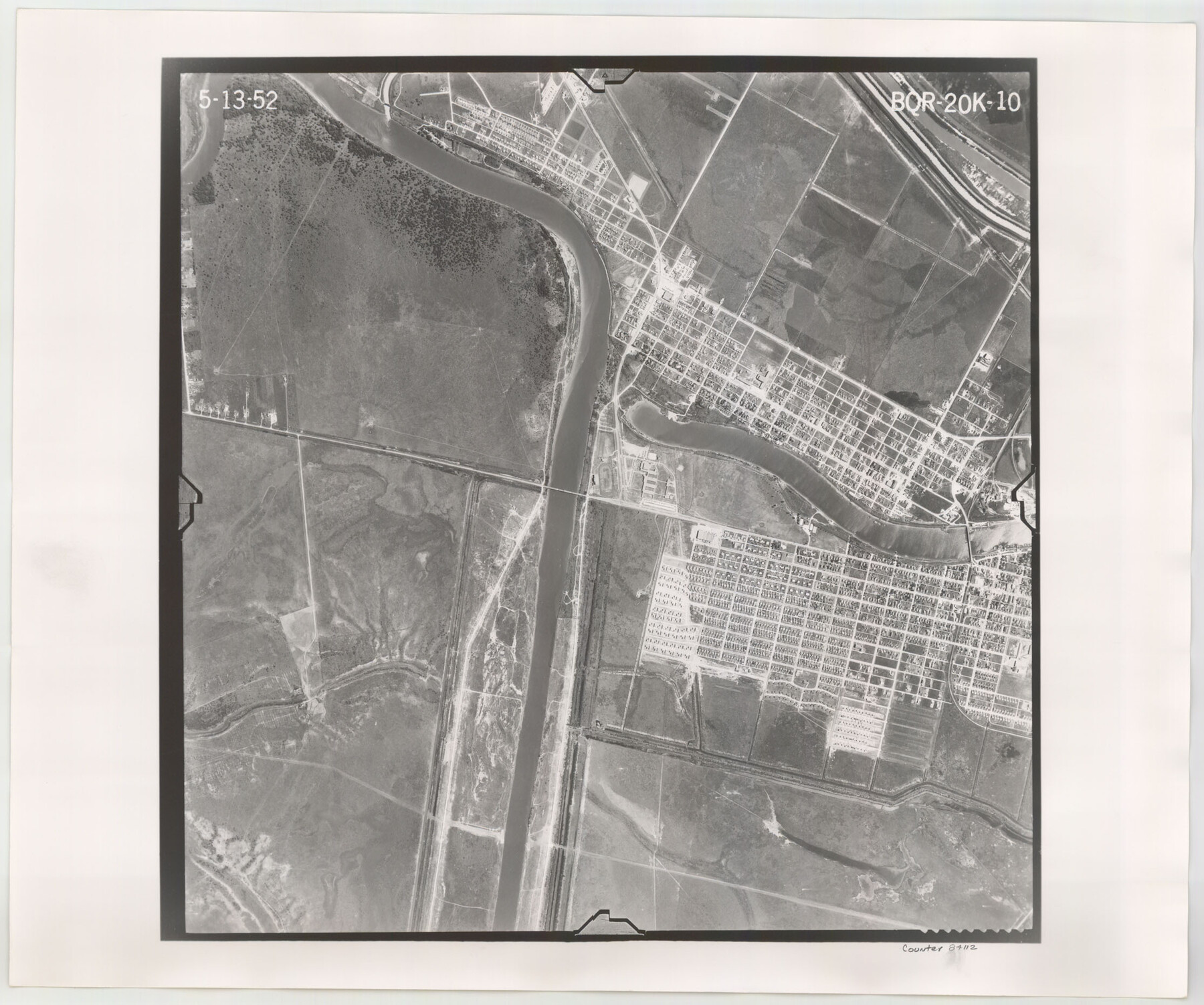
Flight Mission No. BQR-20K, Frame 10, Brazoria County
BQR-20K-10
-
Map/Doc
84112
-
Collection
General Map Collection
-
Object Dates
1952/5/13 (Creation Date)
-
People and Organizations
U. S. Department of Agriculture (Publisher)
-
Counties
Brazoria
-
Subjects
Aerial Photograph
-
Height x Width
18.6 x 22.3 inches
47.2 x 56.6 cm
-
Comments
Flown by Aero Exploration Company of Tulsa, Oklahoma.
Part of: General Map Collection
Ramon de la Garza 11 Leagues Houston and Robertson Districts

Print $2.00
- Digital $50.00
Ramon de la Garza 11 Leagues Houston and Robertson Districts
Size 11.5 x 8.5 inches
Map/Doc 181

Index for Texas Railroad ROW & track maps available on microfilm at THD & Archives and Records

Print $2.00
- Digital $50.00
Index for Texas Railroad ROW & track maps available on microfilm at THD & Archives and Records
1977
Size 11.2 x 8.8 inches
Map/Doc 60758
Wichita County Sketch File 23

Print $20.00
- Digital $50.00
Wichita County Sketch File 23
1911
Size 32.8 x 29.4 inches
Map/Doc 10432
Polk County Working Sketch 5

Print $20.00
- Digital $50.00
Polk County Working Sketch 5
1926
Size 17.9 x 23.2 inches
Map/Doc 71620
Montgomery County Working Sketch 17

Print $20.00
- Digital $50.00
Montgomery County Working Sketch 17
1934
Size 39.0 x 36.9 inches
Map/Doc 71124
Coast Chart No. 210 - Aransas Pass and Corpus Christi Bay with the coast to latitude 27° 12', Texas

Print $20.00
- Digital $50.00
Coast Chart No. 210 - Aransas Pass and Corpus Christi Bay with the coast to latitude 27° 12', Texas
1907
Size 15.4 x 23.5 inches
Map/Doc 73451
Irion County Sketch File 10

Print $20.00
- Digital $50.00
Irion County Sketch File 10
1936
Size 16.7 x 30.5 inches
Map/Doc 11825
Flight Mission No. DQN-5K, Frame 23, Calhoun County

Print $20.00
- Digital $50.00
Flight Mission No. DQN-5K, Frame 23, Calhoun County
1953
Size 18.5 x 22.1 inches
Map/Doc 84374
Western Hemisphere

Print $20.00
- Digital $50.00
Western Hemisphere
1885
Size 12.2 x 9.0 inches
Map/Doc 93510
Gaines County Rolled Sketch 25

Print $20.00
- Digital $50.00
Gaines County Rolled Sketch 25
1977
Size 23.6 x 19.4 inches
Map/Doc 5939
Menard County Working Sketch 5

Print $20.00
- Digital $50.00
Menard County Working Sketch 5
1921
Size 17.2 x 22.3 inches
Map/Doc 70952
You may also like
[Block V and surrounding surveys]
![90293, [Block V and surrounding surveys], Twichell Survey Records](https://historictexasmaps.com/wmedia_w700/maps/90293-1.tif.jpg)
Print $20.00
- Digital $50.00
[Block V and surrounding surveys]
Size 12.0 x 12.6 inches
Map/Doc 90293
Aransas County Working Sketch 14

Print $20.00
- Digital $50.00
Aransas County Working Sketch 14
1951
Size 22.5 x 22.3 inches
Map/Doc 67181
Map of north end of Brazos Island

Print $20.00
- Digital $50.00
Map of north end of Brazos Island
1845
Size 24.3 x 18.3 inches
Map/Doc 72919
Comal County Working Sketch 12

Print $20.00
- Digital $50.00
Comal County Working Sketch 12
1987
Size 31.1 x 29.6 inches
Map/Doc 68178
Uvalde County Sketch File 4

Print $22.00
- Digital $50.00
Uvalde County Sketch File 4
1879
Size 12.8 x 8.3 inches
Map/Doc 38951
General Highway Map, Hardin County, Texas

Print $20.00
General Highway Map, Hardin County, Texas
1940
Size 18.4 x 24.8 inches
Map/Doc 79114
Cherokee County Working Sketch Graphic Index

Print $40.00
- Digital $50.00
Cherokee County Working Sketch Graphic Index
1933
Size 56.7 x 40.0 inches
Map/Doc 76492
Denton County Sketch File 12

Print $4.00
- Digital $50.00
Denton County Sketch File 12
1856
Size 8.3 x 10.3 inches
Map/Doc 20711
Jackson County Sketch File 10

Print $26.00
- Digital $50.00
Jackson County Sketch File 10
1898
Size 11.4 x 8.6 inches
Map/Doc 27653
Glasscock County

Print $20.00
- Digital $50.00
Glasscock County
1933
Size 41.1 x 34.7 inches
Map/Doc 77290
Working Sketch Bastrop County

Print $20.00
- Digital $50.00
Working Sketch Bastrop County
1923
Size 23.2 x 13.0 inches
Map/Doc 90151
Eastland County Working Sketch 1

Print $3.00
- Digital $50.00
Eastland County Working Sketch 1
1907
Size 13.8 x 11.0 inches
Map/Doc 68782