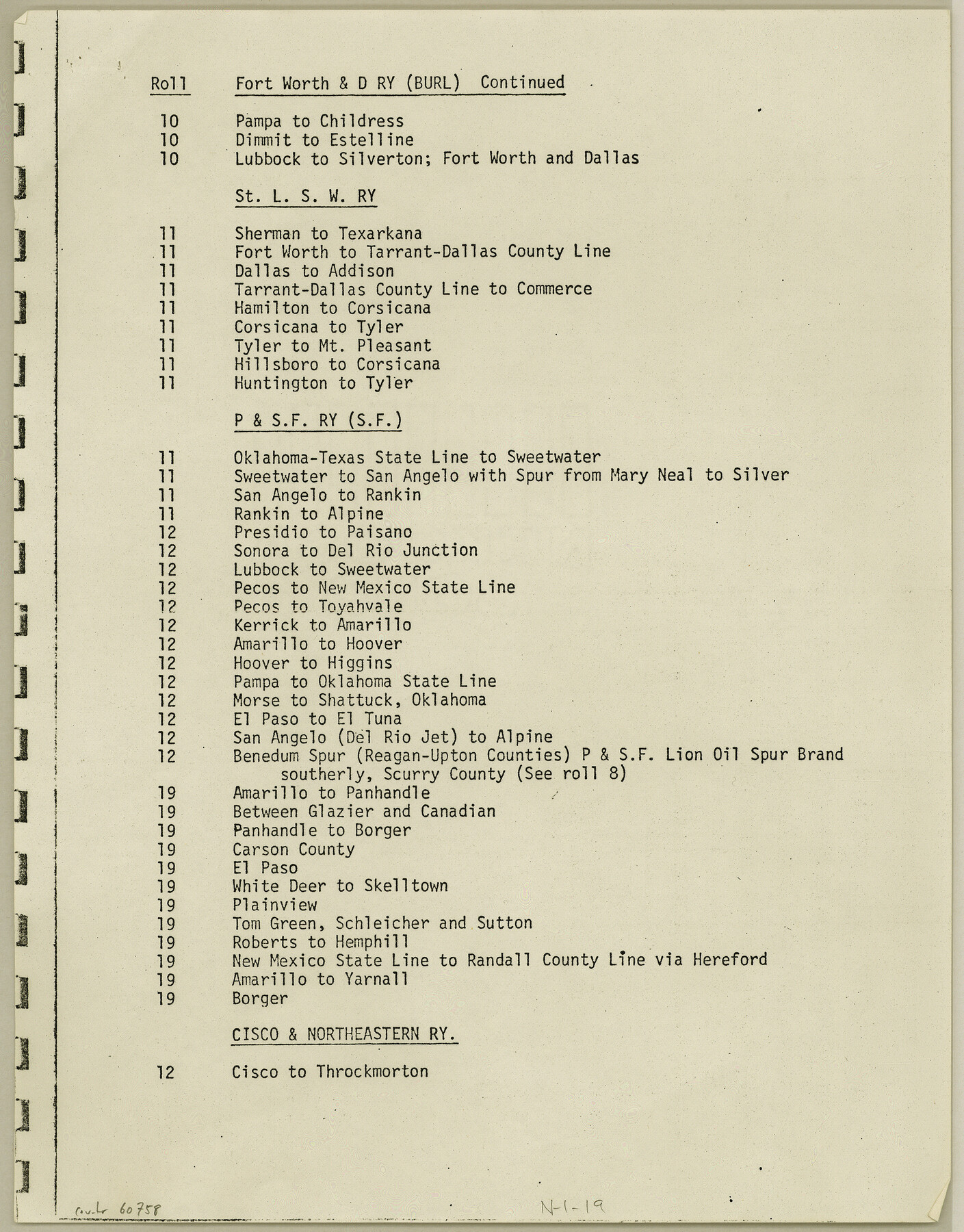
Index for Texas Railroad ROW & track maps available on microfilm at THD & Archives and Records
N-1-19
-
Map/Doc
60758
-
Collection
General Map Collection
-
Object Dates
1977 (Creation Date)
-
Height x Width
11.2 x 8.8 inches
28.4 x 22.4 cm
Part of: General Map Collection
Flight Mission No. DCL-7C, Frame 62, Kenedy County

Print $20.00
- Digital $50.00
Flight Mission No. DCL-7C, Frame 62, Kenedy County
1943
Size 15.4 x 15.3 inches
Map/Doc 86050
Hockley County

Print $20.00
- Digital $50.00
Hockley County
1954
Size 42.7 x 38.2 inches
Map/Doc 73181
Flight Mission No. BRA-16M, Frame 182, Jefferson County

Print $20.00
- Digital $50.00
Flight Mission No. BRA-16M, Frame 182, Jefferson County
1953
Size 18.6 x 22.4 inches
Map/Doc 85780
Culberson County Working Sketch 64

Print $20.00
- Digital $50.00
Culberson County Working Sketch 64
1975
Size 46.5 x 30.8 inches
Map/Doc 68518
Coast Chart No. 210 Aransas Pass and Corpus Christi Bay with the coast to latitude 27° 12' Texas

Print $20.00
- Digital $50.00
Coast Chart No. 210 Aransas Pass and Corpus Christi Bay with the coast to latitude 27° 12' Texas
1887
Size 27.1 x 18.3 inches
Map/Doc 72804
Map of Leon County

Print $40.00
- Digital $50.00
Map of Leon County
1916
Size 49.3 x 42.5 inches
Map/Doc 66901
Wise County Sketch File 14

Print $24.00
- Digital $50.00
Wise County Sketch File 14
1855
Size 12.8 x 8.2 inches
Map/Doc 40548
El Paso County Working Sketch 44

Print $20.00
- Digital $50.00
El Paso County Working Sketch 44
1992
Size 25.6 x 25.4 inches
Map/Doc 69066
Reagan County Sketch File 27

Print $8.00
- Digital $50.00
Reagan County Sketch File 27
1949
Size 11.4 x 8.7 inches
Map/Doc 35021
United States - Gulf Coast - Galveston to Rio Grande

Print $20.00
- Digital $50.00
United States - Gulf Coast - Galveston to Rio Grande
1949
Size 26.6 x 18.2 inches
Map/Doc 72756
Yoakum County Working Sketch 1

Print $20.00
- Digital $50.00
Yoakum County Working Sketch 1
1949
Size 18.5 x 19.1 inches
Map/Doc 62023
Jefferson County Sketch File 3

Print $8.00
- Digital $50.00
Jefferson County Sketch File 3
1849
Size 8.2 x 7.8 inches
Map/Doc 28097
You may also like
Flight Mission No. DQO-3K, Frame 37, Galveston County

Print $20.00
- Digital $50.00
Flight Mission No. DQO-3K, Frame 37, Galveston County
1952
Size 18.7 x 22.6 inches
Map/Doc 85078
Hudspeth County Sketch File 53

Print $6.00
- Digital $50.00
Hudspeth County Sketch File 53
1993
Size 14.3 x 8.9 inches
Map/Doc 27076
Winkler County Working Sketch 8

Print $20.00
- Digital $50.00
Winkler County Working Sketch 8
1958
Size 31.9 x 30.7 inches
Map/Doc 72602
The Republic County of Gonzales. December 18, 1837

Print $20.00
The Republic County of Gonzales. December 18, 1837
2020
Size 14.7 x 21.7 inches
Map/Doc 96154
Goliad County Sketch File 41a

Print $4.00
- Digital $50.00
Goliad County Sketch File 41a
1958
Size 11.3 x 8.8 inches
Map/Doc 24347
Andrews County Sketch File 5

Print $4.00
- Digital $50.00
Andrews County Sketch File 5
1936
Size 11.8 x 8.8 inches
Map/Doc 12823
Burnet County Rolled Sketch 7

Print $20.00
- Digital $50.00
Burnet County Rolled Sketch 7
1987
Size 18.4 x 24.0 inches
Map/Doc 5357
Chambers County Rolled Sketch 32

Print $20.00
- Digital $50.00
Chambers County Rolled Sketch 32
1951
Size 26.7 x 37.8 inches
Map/Doc 5432
Childress County Sketch File 2a

Print $20.00
- Digital $50.00
Childress County Sketch File 2a
Size 18.3 x 34.8 inches
Map/Doc 11077
Travis County Working Sketch 19

Print $20.00
- Digital $50.00
Travis County Working Sketch 19
1945
Size 32.2 x 40.6 inches
Map/Doc 69403
[Maps of surveys in Reeves & Culberson Cos]
![61133, [Maps of surveys in Reeves & Culberson Cos], General Map Collection](https://historictexasmaps.com/wmedia_w700/maps/61133.tif.jpg)
Print $20.00
- Digital $50.00
[Maps of surveys in Reeves & Culberson Cos]
1937
Size 30.7 x 24.8 inches
Map/Doc 61133
Bird's Eye View of New Braunfels, Comal County, Texas

Print $20.00
Bird's Eye View of New Braunfels, Comal County, Texas
1881
Size 17.0 x 24.1 inches
Map/Doc 89200