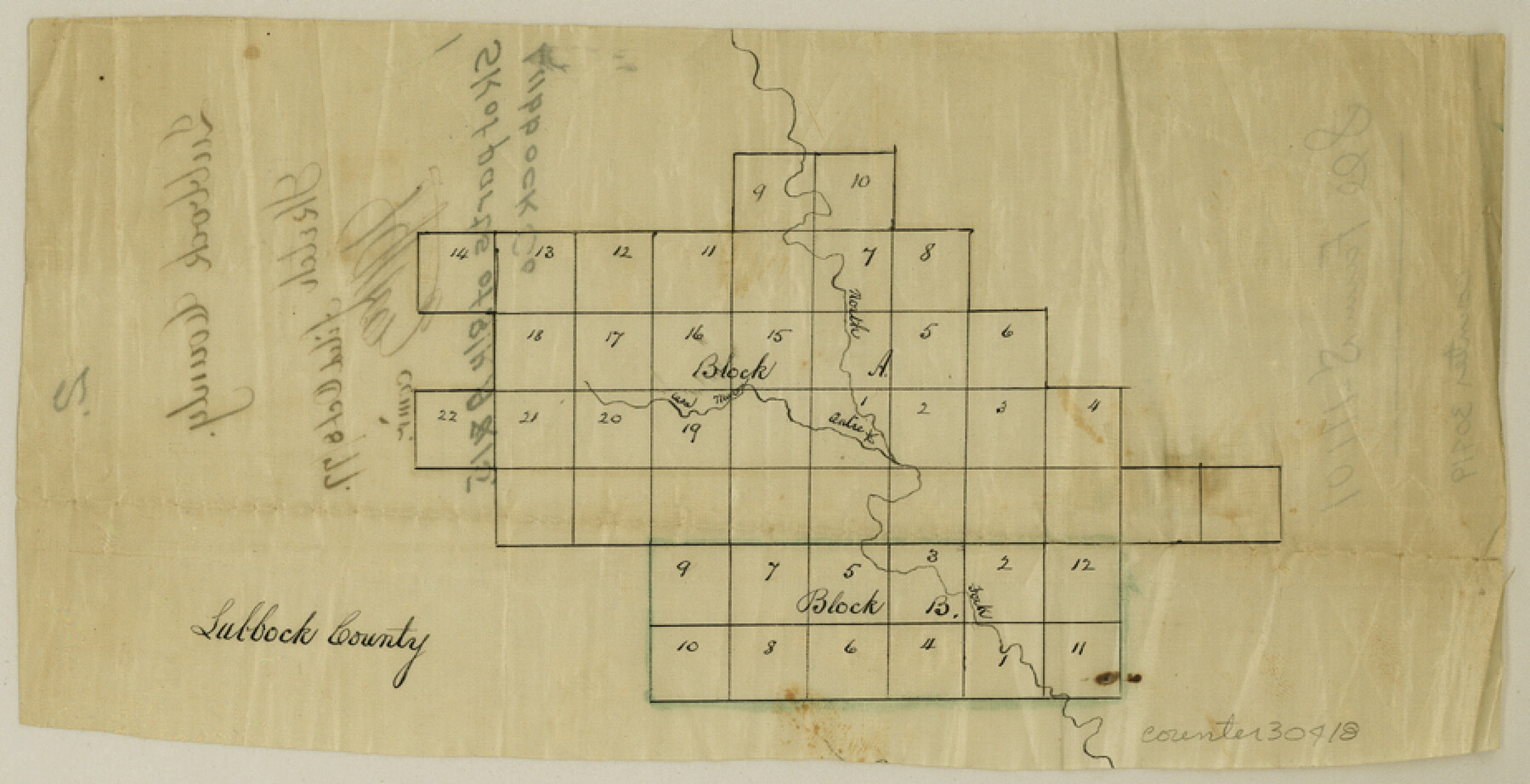
Lubbock County Sketch File 2
[Sketch of parts of Blocks A and B surrounding county seat]
-
Map/Doc
30418
-
Collection
General Map Collection
-
Object Dates
10/8/1977 (File Date)
-
Counties
Lubbock
-
Subjects
Surveying Sketch File
-
Height x Width
4.7 x 9.2 inches
11.9 x 23.4 cm
-
Medium
paper, manuscript
-
Features
North Fork
Part of: General Map Collection

Bandera County Rolled Sketch 4

Print $20.00
- Digital $50.00
Bandera County Rolled Sketch 4
1963
Size 36.0 x 28.5 inches
Map/Doc 5116
Flight Mission No. CUG-3P, Frame 46, Kleberg County

Print $20.00
- Digital $50.00
Flight Mission No. CUG-3P, Frame 46, Kleberg County
1956
Size 18.5 x 22.2 inches
Map/Doc 86251
Flight Mission No. DQN-6K, Frame 4, Calhoun County

Print $20.00
- Digital $50.00
Flight Mission No. DQN-6K, Frame 4, Calhoun County
1953
Size 18.4 x 22.1 inches
Map/Doc 84426
Sutton County Rolled Sketch 35

Print $20.00
- Digital $50.00
Sutton County Rolled Sketch 35
1886
Size 30.3 x 28.4 inches
Map/Doc 7879
Controlled Mosaic by Jack Amman Photogrammetric Engineers, Inc - Sheet 36

Print $20.00
- Digital $50.00
Controlled Mosaic by Jack Amman Photogrammetric Engineers, Inc - Sheet 36
1954
Size 20.0 x 24.0 inches
Map/Doc 83489
Burnet County Sketch File 26

Print $42.00
- Digital $50.00
Burnet County Sketch File 26
Size 16.2 x 12.7 inches
Map/Doc 16727
Hays County Sketch File 16

Print $4.00
- Digital $50.00
Hays County Sketch File 16
1857
Size 12.8 x 8.3 inches
Map/Doc 26227
Flight Mission No. DIX-10P, Frame 62, Aransas County

Print $20.00
- Digital $50.00
Flight Mission No. DIX-10P, Frame 62, Aransas County
1956
Size 18.8 x 22.4 inches
Map/Doc 83923
Map of Cherokee County

Print $20.00
- Digital $50.00
Map of Cherokee County
1879
Size 28.5 x 21.4 inches
Map/Doc 4517
San Augustine County Working Sketch 25

Print $20.00
- Digital $50.00
San Augustine County Working Sketch 25
1976
Size 28.0 x 36.6 inches
Map/Doc 63713
Sabine County Working Sketch 11

Print $20.00
- Digital $50.00
Sabine County Working Sketch 11
1931
Size 30.9 x 34.0 inches
Map/Doc 63682
You may also like
Flight Mission No. BQR-16K, Frame 33, Brazoria County

Print $20.00
- Digital $50.00
Flight Mission No. BQR-16K, Frame 33, Brazoria County
1952
Size 18.5 x 22.3 inches
Map/Doc 84100
Glasscock County

Print $20.00
- Digital $50.00
Glasscock County
1933
Size 41.1 x 34.7 inches
Map/Doc 77290
Flight Mission No. DQN-2K, Frame 41, Calhoun County

Print $20.00
- Digital $50.00
Flight Mission No. DQN-2K, Frame 41, Calhoun County
1953
Size 18.5 x 22.2 inches
Map/Doc 84246
Bee County Working Sketch 12

Print $20.00
- Digital $50.00
Bee County Working Sketch 12
1943
Size 25.4 x 19.9 inches
Map/Doc 67262
Fisher County Boundary File 3

Print $32.00
- Digital $50.00
Fisher County Boundary File 3
Size 8.2 x 4.2 inches
Map/Doc 53428
La Salle County Sketch File 20A

Print $29.00
- Digital $50.00
La Salle County Sketch File 20A
1852
Size 19.5 x 33.6 inches
Map/Doc 11984
University Land Loving-Ward-Winkler Counties

Print $20.00
- Digital $50.00
University Land Loving-Ward-Winkler Counties
1931
Size 24.7 x 33.2 inches
Map/Doc 2448
General Highway Map, Caldwell County, Texas

Print $20.00
General Highway Map, Caldwell County, Texas
1940
Size 18.5 x 25.2 inches
Map/Doc 79034
Flight Mission No. BQR-22K, Frame 44, Brazoria County

Print $20.00
- Digital $50.00
Flight Mission No. BQR-22K, Frame 44, Brazoria County
1953
Size 18.6 x 22.3 inches
Map/Doc 84128
Brewster County Sketch File C

Print $40.00
- Digital $50.00
Brewster County Sketch File C
1911
Size 18.6 x 26.6 inches
Map/Doc 10976
Hudspeth County Rolled Sketch 30

Print $20.00
- Digital $50.00
Hudspeth County Rolled Sketch 30
1924
Size 36.0 x 47.3 inches
Map/Doc 9210
[Map of California and Nevada]
![96620, [Map of California and Nevada], Cobb Digital Map Collection](https://historictexasmaps.com/wmedia_w700/maps/96620.tif.jpg)
Print $20.00
- Digital $50.00
[Map of California and Nevada]
1869
Size 9.1 x 10.6 inches
Map/Doc 96620