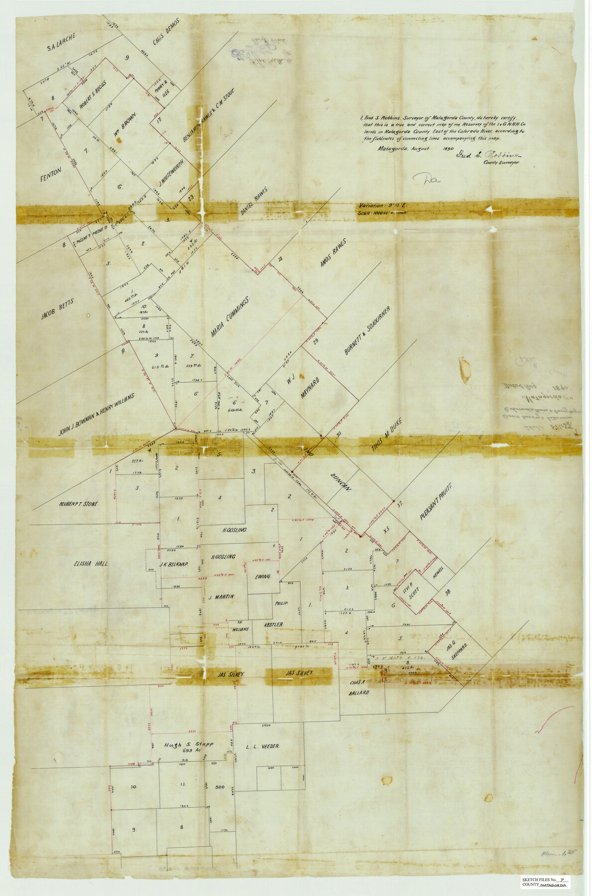
Matagorda County Sketch File 7
Surveys Between Colorado River & [Caney] Bayou, Matagorda County, Texas
-
Map/Doc
12038
-
Collection
General Map Collection
-
Object Dates
8/1890 (Creation Date)
9/16/1890 (File Date)
8/1890 (Survey Date)
-
People and Organizations
Fred S. Robbins (Surveyor/Engineer)
-
Counties
Matagorda
-
Subjects
Surveying Sketch File
-
Height x Width
37.3 x 24.6 inches
94.7 x 62.5 cm
-
Medium
paper, manuscript
Part of: General Map Collection
Concho County Sketch File 7

Print $6.00
- Digital $50.00
Concho County Sketch File 7
1857
Size 16.4 x 11.5 inches
Map/Doc 19129
Levee Improvement Districts Width of Floodways - South Sulphur River

Print $6.00
- Digital $50.00
Levee Improvement Districts Width of Floodways - South Sulphur River
1918
Size 19.6 x 34.1 inches
Map/Doc 65175
Karte von den Vermessungen im Grant und in der Gegend zwischen demselben und Neu Braunfels

Print $20.00
- Digital $50.00
Karte von den Vermessungen im Grant und in der Gegend zwischen demselben und Neu Braunfels
1850
Size 24.0 x 19.0 inches
Map/Doc 94446
Flight Mission No. BRA-3M, Frame 193, Jefferson County

Print $20.00
- Digital $50.00
Flight Mission No. BRA-3M, Frame 193, Jefferson County
1953
Size 18.6 x 22.3 inches
Map/Doc 85408
Vicinity map showing railroads serving the ports of Galveston, Houston and Texas City, Texas

Print $20.00
- Digital $50.00
Vicinity map showing railroads serving the ports of Galveston, Houston and Texas City, Texas
1924
Size 9.3 x 14.8 inches
Map/Doc 97164
Trinity County Working Sketch 19

Print $20.00
- Digital $50.00
Trinity County Working Sketch 19
1982
Size 14.7 x 11.1 inches
Map/Doc 69468
Map Showing the Route of the Arkansas Regiment from Shreveport La. To San Antonio de Bexar Texas

Print $20.00
- Digital $50.00
Map Showing the Route of the Arkansas Regiment from Shreveport La. To San Antonio de Bexar Texas
Size 12.5 x 19.5 inches
Map/Doc 94000
Galveston County Sketch File 27a

Print $23.00
- Digital $50.00
Galveston County Sketch File 27a
1899
Size 13.6 x 8.8 inches
Map/Doc 23399
Preliminary Chart No. 31 of the Sea Coast of the United States from Galveston Bay to Matagorda Bay, Texas

Print $20.00
- Digital $50.00
Preliminary Chart No. 31 of the Sea Coast of the United States from Galveston Bay to Matagorda Bay, Texas
1857
Size 22.7 x 38.7 inches
Map/Doc 69949
Harris County Sketch File 86

Print $20.00
- Digital $50.00
Harris County Sketch File 86
1894
Size 34.7 x 21.3 inches
Map/Doc 11674
Map of R. H. Welder Ranch, San Patricio County, Texas

Print $40.00
- Digital $50.00
Map of R. H. Welder Ranch, San Patricio County, Texas
1953
Size 30.0 x 61.4 inches
Map/Doc 61406
Flight Mission No. DIX-10P, Frame 65, Aransas County

Print $20.00
- Digital $50.00
Flight Mission No. DIX-10P, Frame 65, Aransas County
1956
Size 18.6 x 22.3 inches
Map/Doc 83926
You may also like
Midland County Working Sketch 12

Print $20.00
- Digital $50.00
Midland County Working Sketch 12
1951
Size 23.1 x 19.0 inches
Map/Doc 70992
Frio County Rolled Sketch 15

Print $20.00
- Digital $50.00
Frio County Rolled Sketch 15
1949
Size 26.1 x 39.0 inches
Map/Doc 5922
Flight Mission No. DQO-2K, Frame 164, Galveston County

Print $20.00
- Digital $50.00
Flight Mission No. DQO-2K, Frame 164, Galveston County
1952
Size 18.7 x 22.3 inches
Map/Doc 85053
General Highway Map, Bell County, Texas

Print $20.00
General Highway Map, Bell County, Texas
1961
Size 18.3 x 25.1 inches
Map/Doc 79366
Goliad County Rolled Sketch 3

Print $4.00
- Digital $50.00
Goliad County Rolled Sketch 3
1945
Size 24.2 x 26.9 inches
Map/Doc 6024
[Meander of Yellow House Creek from Northeast Corner of Section 37, Block S to Northeast corner of Section 3, Block O]
![91387, [Meander of Yellow House Creek from Northeast Corner of Section 37, Block S to Northeast corner of Section 3, Block O], Twichell Survey Records](https://historictexasmaps.com/wmedia_w700/maps/91387-1.tif.jpg)
Print $20.00
- Digital $50.00
[Meander of Yellow House Creek from Northeast Corner of Section 37, Block S to Northeast corner of Section 3, Block O]
Size 24.8 x 32.7 inches
Map/Doc 91387
Archer County Sketch File 20

Print $6.00
- Digital $50.00
Archer County Sketch File 20
1936
Size 11.0 x 8.7 inches
Map/Doc 13655
Edwards County Working Sketch 14

Print $20.00
- Digital $50.00
Edwards County Working Sketch 14
1924
Size 19.4 x 31.0 inches
Map/Doc 68890
Pecos County Working Sketch 137

Print $20.00
- Digital $50.00
Pecos County Working Sketch 137
1981
Size 32.3 x 28.4 inches
Map/Doc 71611
[H. & T. C. RR. Company, Block 47 and vicinity]
![91159, [H. & T. C. RR. Company, Block 47 and vicinity], Twichell Survey Records](https://historictexasmaps.com/wmedia_w700/maps/91159-1.tif.jpg)
Print $20.00
- Digital $50.00
[H. & T. C. RR. Company, Block 47 and vicinity]
Size 18.7 x 19.9 inches
Map/Doc 91159
Presidio County Rolled Sketch 77

Print $20.00
- Digital $50.00
Presidio County Rolled Sketch 77
1940
Size 47.1 x 43.0 inches
Map/Doc 9778
Map of Burnet County

Print $20.00
- Digital $50.00
Map of Burnet County
1862
Size 27.1 x 22.5 inches
Map/Doc 3353