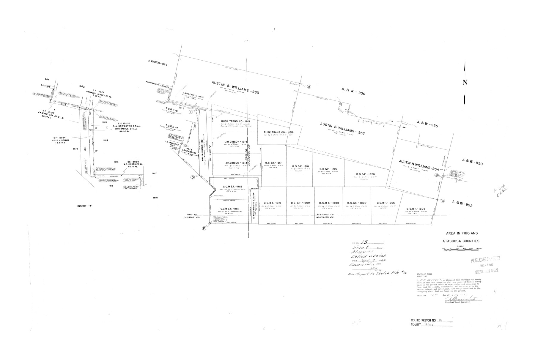
Frio County Rolled Sketch 15
Area in Frio and Atascosa Counties
-
Map/Doc
5922
-
Collection
General Map Collection
-
Object Dates
8/16/1949 (Creation Date)
9/3/1949 (File Date)
-
People and Organizations
F.T. Drought (Surveyor/Engineer)
-
Counties
Frio Atascosa
-
Subjects
Surveying Rolled Sketch
-
Height x Width
26.1 x 39.0 inches
66.3 x 99.1 cm
Part of: General Map Collection
Montgomery County Rolled Sketch 24

Print $20.00
- Digital $50.00
Montgomery County Rolled Sketch 24
Size 30.0 x 31.9 inches
Map/Doc 9534
Kimble County Rolled Sketch 24

Print $20.00
- Digital $50.00
Kimble County Rolled Sketch 24
1934
Size 31.6 x 17.7 inches
Map/Doc 6514
Wilbarger County Rolled Sketch 6

Print $20.00
- Digital $50.00
Wilbarger County Rolled Sketch 6
1885
Size 20.3 x 28.0 inches
Map/Doc 8256
Map Exhibiting the line of the Southern Trans-Continental R.R. from Marshall to Texarkana from Texarkana to Forth Worth

Print $20.00
- Digital $50.00
Map Exhibiting the line of the Southern Trans-Continental R.R. from Marshall to Texarkana from Texarkana to Forth Worth
1872
Size 24.6 x 47.8 inches
Map/Doc 64241
Young County Working Sketch 27

Print $20.00
- Digital $50.00
Young County Working Sketch 27
1982
Size 24.3 x 32.6 inches
Map/Doc 62050
San Saba County Working Sketch 3

Print $20.00
- Digital $50.00
San Saba County Working Sketch 3
1941
Size 27.3 x 20.7 inches
Map/Doc 63791
Flight Mission No. DQN-2K, Frame 6, Calhoun County

Print $20.00
- Digital $50.00
Flight Mission No. DQN-2K, Frame 6, Calhoun County
1953
Size 18.4 x 22.2 inches
Map/Doc 84223
Flight Mission No. BQY-14M, Frame 182, Harris County

Print $20.00
- Digital $50.00
Flight Mission No. BQY-14M, Frame 182, Harris County
1953
Size 18.5 x 22.4 inches
Map/Doc 85298
Presidio County Working Sketch 140

Print $20.00
- Digital $50.00
Presidio County Working Sketch 140
1990
Size 29.8 x 39.9 inches
Map/Doc 71818
Bell County Working Sketch 16

Print $20.00
- Digital $50.00
Bell County Working Sketch 16
1983
Size 46.5 x 35.4 inches
Map/Doc 67356
La Salle County Working Sketch 15

Print $20.00
- Digital $50.00
La Salle County Working Sketch 15
1935
Size 27.4 x 17.2 inches
Map/Doc 70316
Starr County Rolled Sketch 23

Print $20.00
- Digital $50.00
Starr County Rolled Sketch 23
1938
Size 36.8 x 24.9 inches
Map/Doc 7807
You may also like
Working Sketch in Stephens County

Print $20.00
- Digital $50.00
Working Sketch in Stephens County
1919
Size 15.4 x 18.6 inches
Map/Doc 91912
Waller County Working Sketch 5

Print $20.00
- Digital $50.00
Waller County Working Sketch 5
1966
Size 23.1 x 27.1 inches
Map/Doc 72304
Right-of-way & Track Map Dawson Railway Operated by the El Paso & Southwestern Company Station 1444+61.7 to Station 1655+23.4

Print $40.00
- Digital $50.00
Right-of-way & Track Map Dawson Railway Operated by the El Paso & Southwestern Company Station 1444+61.7 to Station 1655+23.4
1910
Size 56.7 x 24.8 inches
Map/Doc 89655
Upton County Rolled Sketch 18

Print $40.00
- Digital $50.00
Upton County Rolled Sketch 18
1933
Size 38.3 x 55.5 inches
Map/Doc 10039
Flight Mission No. CRC-2R, Frame 5, Chambers County

Print $20.00
- Digital $50.00
Flight Mission No. CRC-2R, Frame 5, Chambers County
1956
Size 18.7 x 22.4 inches
Map/Doc 84724
Potter County Working Sketch 3

Print $20.00
- Digital $50.00
Potter County Working Sketch 3
1920
Size 42.1 x 16.8 inches
Map/Doc 71663
No. 3 Chart of Channel connecting Corpus Christi Bay with Aransas Bay, Texas

Print $20.00
- Digital $50.00
No. 3 Chart of Channel connecting Corpus Christi Bay with Aransas Bay, Texas
1878
Size 18.1 x 27.8 inches
Map/Doc 72782

Webb County Sketch File 4a

Print $8.00
- Digital $50.00
Webb County Sketch File 4a
1877
Size 11.6 x 4.0 inches
Map/Doc 39718
Brazoria County Working Sketch 21

Print $20.00
- Digital $50.00
Brazoria County Working Sketch 21
1954
Size 41.5 x 41.8 inches
Map/Doc 67506
Lee County Boundary File 2

Print $25.00
- Digital $50.00
Lee County Boundary File 2
Size 14.2 x 8.6 inches
Map/Doc 56269
Duval County Sketch File 52

Print $20.00
- Digital $50.00
Duval County Sketch File 52
1936
Size 21.0 x 28.6 inches
Map/Doc 11402