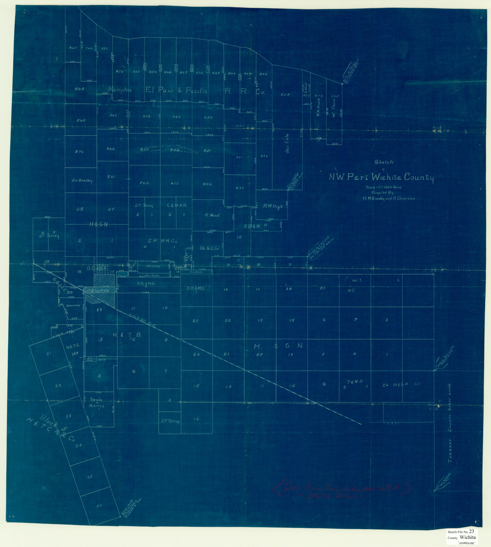
Wichita County Sketch File 23
Sketch of N.W. Part Wichita County
-
Map/Doc
10432
-
Collection
General Map Collection
-
Object Dates
10/14/1911 (Creation Date)
-
People and Organizations
H.M. Snoddy (Compiler)
Albert Devereux (Compiler)
-
Counties
Wichita
-
Subjects
Surveying Sketch File
-
Height x Width
32.8 x 29.4 inches
83.3 x 74.7 cm
-
Medium
blueprint/diazo
-
Scale
1" = 1000 varas
-
Comments
See Wichita County Sketch FIle 23a (40109) for related correspondence.
-
Features
Electra
FW&DC
Related maps
Wichita County Sketch File 23a

Print $10.00
- Digital $50.00
Wichita County Sketch File 23a
1911
Size 14.2 x 8.8 inches
Map/Doc 40109
Part of: General Map Collection
Denton County Working Sketch 36

Print $20.00
- Digital $50.00
Denton County Working Sketch 36
2008
Size 18.5 x 29.0 inches
Map/Doc 88877
Matagorda County NRC Article 33.136 Sketch 13

Print $22.00
- Digital $50.00
Matagorda County NRC Article 33.136 Sketch 13
Size 24.2 x 36.0 inches
Map/Doc 95720
Comanche County Sketch File 18

Print $4.00
- Digital $50.00
Comanche County Sketch File 18
Size 8.4 x 7.8 inches
Map/Doc 19091
Cottle County Boundary File 1

Print $22.00
- Digital $50.00
Cottle County Boundary File 1
Size 8.8 x 3.8 inches
Map/Doc 51944
Briscoe County Sketch File 14

Print $20.00
- Digital $50.00
Briscoe County Sketch File 14
1910
Size 14.2 x 8.5 inches
Map/Doc 16509
El Paso County Rolled Sketch 10

Print $93.00
- Digital $50.00
El Paso County Rolled Sketch 10
1883
Size 42.4 x 61.3 inches
Map/Doc 8853
Atascosa County Rolled Sketch 27

Print $20.00
- Digital $50.00
Atascosa County Rolled Sketch 27
2012
Size 25.9 x 34.1 inches
Map/Doc 95410
Galveston/Galveston Island, Texas

Galveston/Galveston Island, Texas
Size 18.4 x 24.3 inches
Map/Doc 94346
Wilson County Working Sketch 14

Print $20.00
- Digital $50.00
Wilson County Working Sketch 14
1987
Size 31.9 x 36.2 inches
Map/Doc 72594
Fisher County Sketch File 9

Print $4.00
- Digital $50.00
Fisher County Sketch File 9
1893
Size 11.1 x 8.5 inches
Map/Doc 22575
Kent County Rolled Sketch 5

Print $20.00
- Digital $50.00
Kent County Rolled Sketch 5
1951
Size 43.7 x 36.9 inches
Map/Doc 78522
Flight Mission No. BQY-14M, Frame 184, Harris County

Print $20.00
- Digital $50.00
Flight Mission No. BQY-14M, Frame 184, Harris County
1953
Size 18.6 x 22.4 inches
Map/Doc 85300
You may also like
General Highway Map, Anderson County, Texas

Print $20.00
General Highway Map, Anderson County, Texas
1936
Size 18.4 x 24.9 inches
Map/Doc 79001
McMullen County Sketch File 5

Print $4.00
- Digital $50.00
McMullen County Sketch File 5
1854
Size 8.7 x 8.3 inches
Map/Doc 31343
McMullen County Sketch File 25a

Print $22.00
- Digital $50.00
McMullen County Sketch File 25a
1877
Size 8.8 x 12.9 inches
Map/Doc 31386
Goliad County Working Sketch 13

Print $20.00
- Digital $50.00
Goliad County Working Sketch 13
1943
Size 28.3 x 40.8 inches
Map/Doc 63203
Nine Central Panhandle Counties, Texas

Print $20.00
- Digital $50.00
Nine Central Panhandle Counties, Texas
1899
Size 41.3 x 35.3 inches
Map/Doc 89790
Maps of Gulf Intracoastal Waterway, Texas - Sabine River to the Rio Grande and connecting waterways including ship channels

Print $20.00
- Digital $50.00
Maps of Gulf Intracoastal Waterway, Texas - Sabine River to the Rio Grande and connecting waterways including ship channels
1966
Size 14.3 x 20.7 inches
Map/Doc 61998
Surveys on the lines [?] of Plum Creek
![78384, Surveys on the lines [?] of Plum Creek, General Map Collection](https://historictexasmaps.com/wmedia_w700/maps/78384.tif.jpg)
Print $2.00
- Digital $50.00
Surveys on the lines [?] of Plum Creek
Size 10.5 x 8.4 inches
Map/Doc 78384
Pecos County Working Sketch 106

Print $40.00
- Digital $50.00
Pecos County Working Sketch 106
1971
Size 64.9 x 38.1 inches
Map/Doc 71579
Callahan County Sketch File 1

Print $4.00
- Digital $50.00
Callahan County Sketch File 1
Size 9.1 x 8.2 inches
Map/Doc 35851
Flight Mission No. BRE-1P, Frame 11, Nueces County

Print $20.00
- Digital $50.00
Flight Mission No. BRE-1P, Frame 11, Nueces County
1956
Size 18.6 x 22.6 inches
Map/Doc 86619
Medina County Working Sketch 24

Print $20.00
- Digital $50.00
Medina County Working Sketch 24
1984
Size 26.1 x 36.7 inches
Map/Doc 70939
Flight Mission No. DCL-6C, Frame 53, Kenedy County

Print $20.00
- Digital $50.00
Flight Mission No. DCL-6C, Frame 53, Kenedy County
1943
Size 18.6 x 22.4 inches
Map/Doc 85895