Current Miscellaneous File 29
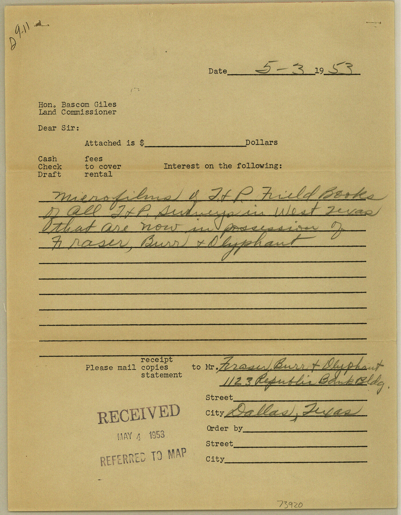
Microfilm of T&P field books. Presented by Mr. Ray McDowell, Dallas, Texas.
-
Map/Doc
73920
-
Collection
General Map Collection
-
Object Dates
1953/5/4 (File Date)
-
Subjects
Railroads Texas and Pacific Railroad
-
Height x Width
11.2 x 8.8 inches
28.5 x 22.4 cm
Part of: General Map Collection
Brazoria County Rolled Sketch 31

Print $20.00
- Digital $50.00
Brazoria County Rolled Sketch 31
Size 25.6 x 45.9 inches
Map/Doc 5169
Texas and part of Mexico & the United States, showing the route of the first Santa Fe Expedition

Print $20.00
- Digital $50.00
Texas and part of Mexico & the United States, showing the route of the first Santa Fe Expedition
1844
Size 18.1 x 13.2 inches
Map/Doc 94035
Travis County Working Sketch 26

Print $20.00
- Digital $50.00
Travis County Working Sketch 26
1951
Size 34.8 x 25.1 inches
Map/Doc 69410
Lynn County Rolled Sketch B

Print $20.00
- Digital $50.00
Lynn County Rolled Sketch B
1908
Size 27.9 x 33.1 inches
Map/Doc 6653
Webb County Working Sketch 52

Print $20.00
- Digital $50.00
Webb County Working Sketch 52
1951
Size 30.8 x 37.3 inches
Map/Doc 72418
Aransas County Sketch File 18

Print $8.00
- Digital $50.00
Aransas County Sketch File 18
1888
Size 12.7 x 8.2 inches
Map/Doc 13149
McCulloch County Working Sketch 3

Print $20.00
- Digital $50.00
McCulloch County Working Sketch 3
1951
Size 30.9 x 36.8 inches
Map/Doc 70678
Flight Mission No. BRA-8M, Frame 68, Jefferson County

Print $20.00
- Digital $50.00
Flight Mission No. BRA-8M, Frame 68, Jefferson County
1953
Size 18.6 x 22.4 inches
Map/Doc 85588
Wichita County Working Sketch 1

Print $20.00
- Digital $50.00
Wichita County Working Sketch 1
Size 23.5 x 24.2 inches
Map/Doc 72510
Fort Bend County State Real Property Sketch 12

Print $40.00
- Digital $50.00
Fort Bend County State Real Property Sketch 12
1986
Size 43.2 x 35.0 inches
Map/Doc 61686
Ector County Boundary File 3

Print $18.00
- Digital $50.00
Ector County Boundary File 3
Size 9.0 x 4.4 inches
Map/Doc 52836
Jefferson County Working Sketch 16

Print $20.00
- Digital $50.00
Jefferson County Working Sketch 16
1954
Size 31.0 x 18.8 inches
Map/Doc 66559
You may also like
Pecos County Sketch File 70

Print $20.00
- Digital $50.00
Pecos County Sketch File 70
1939
Size 21.3 x 20.7 inches
Map/Doc 12181
San Patricio County Rolled Sketch 52

Print $20.00
- Digital $50.00
San Patricio County Rolled Sketch 52
1994
Size 36.7 x 39.4 inches
Map/Doc 7737
Stonewall County Sketch File 15

Print $40.00
- Digital $50.00
Stonewall County Sketch File 15
1905
Size 14.3 x 8.7 inches
Map/Doc 37255
[Capitol Leagues in Lamb County]
![91002, [Capitol Leagues in Lamb County], Twichell Survey Records](https://historictexasmaps.com/wmedia_w700/maps/91002-1.tif.jpg)
Print $20.00
- Digital $50.00
[Capitol Leagues in Lamb County]
Size 19.5 x 23.2 inches
Map/Doc 91002
[Sketch of E.L. RR. Blks. 1, 2, 7]
![89963, [Sketch of E.L. RR. Blks. 1, 2, 7], Twichell Survey Records](https://historictexasmaps.com/wmedia_w700/maps/89963-1.tif.jpg)
Print $20.00
- Digital $50.00
[Sketch of E.L. RR. Blks. 1, 2, 7]
Size 36.8 x 42.8 inches
Map/Doc 89963
University of Texas System University Lands

Print $20.00
- Digital $50.00
University of Texas System University Lands
Size 17.9 x 23.3 inches
Map/Doc 93244
Angelina County Sketch File 3

Print $8.00
- Digital $50.00
Angelina County Sketch File 3
Size 7.7 x 7.6 inches
Map/Doc 12922
Webb County Sketch File 51

Print $4.00
- Digital $50.00
Webb County Sketch File 51
1938
Size 11.3 x 8.8 inches
Map/Doc 39837
Chambers County Rolled Sketch 18

Print $20.00
- Digital $50.00
Chambers County Rolled Sketch 18
1937
Size 42.9 x 29.0 inches
Map/Doc 5426
Polk County Sketch File 45

Print $4.00
- Digital $50.00
Polk County Sketch File 45
Size 11.3 x 8.8 inches
Map/Doc 34376
General Highway Map. Detail of Cities and Towns in Jim Wells County, Texas. City Map of Alice, Jim Wells County, Texas

Print $20.00
General Highway Map. Detail of Cities and Towns in Jim Wells County, Texas. City Map of Alice, Jim Wells County, Texas
1961
Size 24.6 x 18.3 inches
Map/Doc 79544
Aransas County Sketch File 21d

Print $4.00
- Digital $50.00
Aransas County Sketch File 21d
Size 14.4 x 8.9 inches
Map/Doc 13164