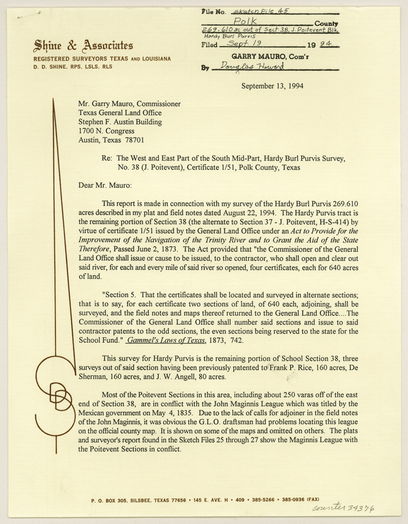
Polk County Sketch File 45
[Report of survey of 269.610 acres being the west and east part of the south mid-part of section 38, J. Poitevent]
-
Map/Doc
34376
-
Collection
General Map Collection
-
Object Dates
9/19/1994 (File Date)
9/13/1994 (Correspondence Date)
8/22/1994 (Survey Date)
-
People and Organizations
Darrell D. Shine (Surveyor/Engineer)
W.H. Matthews (Surveyor/Engineer)
R.W. Hubert (Surveyor/Engineer)
Manry (Surveyor/Engineer)
Gibson (Surveyor/Engineer)
-
Counties
Polk
-
Subjects
Surveying Sketch File
-
Height x Width
11.3 x 8.8 inches
28.7 x 22.4 cm
-
Medium
paper, print
-
Comments
See Polk County Rolled Sketch 33 (7319) for sketch.
-
Features
Trinity River
Related maps
Polk County Rolled Sketch 33

Print $20.00
- Digital $50.00
Polk County Rolled Sketch 33
Size 26.5 x 38.5 inches
Map/Doc 7319
Part of: General Map Collection
Milam County Sketch File 8

Print $20.00
- Digital $50.00
Milam County Sketch File 8
1856
Size 16.8 x 33.7 inches
Map/Doc 12091
Map of the State of Texas [East Part]
![81920, Map of the State of Texas [East Part], General Map Collection](https://historictexasmaps.com/wmedia_w700/maps/81920.tif.jpg)
Print $40.00
- Digital $50.00
Map of the State of Texas [East Part]
1938
Size 67.8 x 37.3 inches
Map/Doc 81920
San Patricio County Sketch File 33

Print $20.00
- Digital $50.00
San Patricio County Sketch File 33
1946
Size 15.5 x 31.0 inches
Map/Doc 12288
Nueces County Rolled Sketch 78

Print $53.00
Nueces County Rolled Sketch 78
1982
Size 18.2 x 24.9 inches
Map/Doc 6945
Comanche County Working Sketch 3

Print $20.00
- Digital $50.00
Comanche County Working Sketch 3
1919
Size 21.9 x 12.6 inches
Map/Doc 68137
Rusk County Sketch File 25

Print $20.00
Rusk County Sketch File 25
1932
Size 20.5 x 20.3 inches
Map/Doc 12272
Hardeman County Sketch File 3

Print $8.00
- Digital $50.00
Hardeman County Sketch File 3
1880
Size 14.2 x 8.8 inches
Map/Doc 24987
Presidio County Rolled Sketch 89

Print $20.00
- Digital $50.00
Presidio County Rolled Sketch 89
1946
Size 34.4 x 25.5 inches
Map/Doc 7374
Flight Mission No. CGI-3N, Frame 133, Cameron County

Print $20.00
- Digital $50.00
Flight Mission No. CGI-3N, Frame 133, Cameron County
1954
Size 18.5 x 22.1 inches
Map/Doc 84606
Dimmit County Working Sketch 42

Print $20.00
- Digital $50.00
Dimmit County Working Sketch 42
1977
Size 33.5 x 39.6 inches
Map/Doc 68703
Presidio County Rolled Sketch T-4

Print $20.00
- Digital $50.00
Presidio County Rolled Sketch T-4
Size 46.6 x 21.7 inches
Map/Doc 10085
General Land Office and State Reclamation Department - An Index Map

Print $20.00
- Digital $50.00
General Land Office and State Reclamation Department - An Index Map
1930
Size 25.8 x 16.4 inches
Map/Doc 3027
You may also like
Gulf of Mexico

Print $20.00
- Digital $50.00
Gulf of Mexico
1905
Size 18.3 x 26.8 inches
Map/Doc 72654
Runnels County Rolled Sketch B

Print $20.00
- Digital $50.00
Runnels County Rolled Sketch B
1891
Size 17.4 x 19.3 inches
Map/Doc 7540
General Highway Map, Hardeman County, Texas

Print $20.00
General Highway Map, Hardeman County, Texas
1940
Size 25.0 x 18.3 inches
Map/Doc 79113
[Sketch for Mineral Application 24072, San Jacinto River]
![65609, [Sketch for Mineral Application 24072, San Jacinto River], General Map Collection](https://historictexasmaps.com/wmedia_w700/maps/65609.tif.jpg)
Print $20.00
- Digital $50.00
[Sketch for Mineral Application 24072, San Jacinto River]
1929
Size 8.4 x 13.9 inches
Map/Doc 65609
Brazoria County Rolled Sketch 41

Print $20.00
- Digital $50.00
Brazoria County Rolled Sketch 41
Size 30.3 x 21.3 inches
Map/Doc 5176
Mason County Sketch File 3a

Print $4.00
- Digital $50.00
Mason County Sketch File 3a
1877
Size 8.3 x 7.9 inches
Map/Doc 30682
Runnels County Working Sketch 24

Print $20.00
- Digital $50.00
Runnels County Working Sketch 24
1952
Size 30.6 x 20.0 inches
Map/Doc 63620
Map of Tom Green County

Print $20.00
- Digital $50.00
Map of Tom Green County
1892
Size 44.0 x 45.1 inches
Map/Doc 63068
Live Oak County Working Sketch 9

Print $20.00
- Digital $50.00
Live Oak County Working Sketch 9
1938
Size 35.7 x 41.1 inches
Map/Doc 70594
Milam County Sketch File 3

Print $4.00
- Digital $50.00
Milam County Sketch File 3
1853
Size 12.9 x 8.1 inches
Map/Doc 31628
San Jacinto County Working Sketch 14

Print $20.00
- Digital $50.00
San Jacinto County Working Sketch 14
1935
Size 25.6 x 26.4 inches
Map/Doc 63727
Chambers County NRC Article 33.136 Location Key Sheet

Print $20.00
- Digital $50.00
Chambers County NRC Article 33.136 Location Key Sheet
1982
Size 27.0 x 22.0 inches
Map/Doc 87908