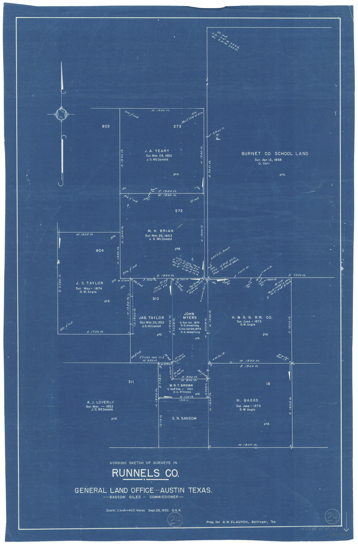
Runnels County Working Sketch 24
-
Map/Doc
63620
-
Collection
General Map Collection
-
Object Dates
9/29/1952 (Creation Date)
-
People and Organizations
Otto G. Kurio (Draftsman)
-
Counties
Runnels
-
Subjects
Surveying Working Sketch
-
Height x Width
30.6 x 20.0 inches
77.7 x 50.8 cm
-
Scale
1" = 400 varas
Part of: General Map Collection
Harris County Rolled Sketch 87A

Print $20.00
- Digital $50.00
Harris County Rolled Sketch 87A
Size 41.1 x 47.6 inches
Map/Doc 78250
[Surveys on San Antonio River and Aransas Bay area]
![141, [Surveys on San Antonio River and Aransas Bay area], General Map Collection](https://historictexasmaps.com/wmedia_w700/maps/141.tif.jpg)
Print $20.00
- Digital $50.00
[Surveys on San Antonio River and Aransas Bay area]
1840
Size 24.1 x 33.0 inches
Map/Doc 141
Flight Mission No. BRE-1P, Frame 128, Nueces County

Print $20.00
- Digital $50.00
Flight Mission No. BRE-1P, Frame 128, Nueces County
1956
Size 18.3 x 22.1 inches
Map/Doc 86694
Briscoe County Working Sketch 10

Print $20.00
- Digital $50.00
Briscoe County Working Sketch 10
1958
Size 30.0 x 24.2 inches
Map/Doc 67813
Archer County Sketch File 17

Print $4.00
- Digital $50.00
Archer County Sketch File 17
1901
Size 11.3 x 8.6 inches
Map/Doc 13653
Hutchinson County Rolled Sketch 37A

Print $40.00
- Digital $50.00
Hutchinson County Rolled Sketch 37A
1950
Size 26.0 x 51.1 inches
Map/Doc 9247
Brazoria County Sketch File 6a

Print $40.00
- Digital $50.00
Brazoria County Sketch File 6a
1862
Size 17.6 x 12.6 inches
Map/Doc 10949
Wichita County

Print $20.00
- Digital $50.00
Wichita County
1924
Size 32.1 x 39.1 inches
Map/Doc 16924
Corpus Christi Harbor

Print $40.00
- Digital $50.00
Corpus Christi Harbor
1972
Size 36.9 x 52.3 inches
Map/Doc 73477
Origin of Imports and Destination of Exports at Galveston, Tex., during 1921

Print $20.00
- Digital $50.00
Origin of Imports and Destination of Exports at Galveston, Tex., during 1921
1921
Size 13.1 x 24.6 inches
Map/Doc 97169
Estes Quadrangle

Print $20.00
- Digital $50.00
Estes Quadrangle
1971
Size 27.8 x 23.6 inches
Map/Doc 73442
Flight Mission No. DQO-2K, Frame 138, Galveston County

Print $20.00
- Digital $50.00
Flight Mission No. DQO-2K, Frame 138, Galveston County
1952
Size 18.8 x 22.6 inches
Map/Doc 85035
You may also like
Map of Tom Green Co.

Print $40.00
- Digital $50.00
Map of Tom Green Co.
1880
Size 42.3 x 51.2 inches
Map/Doc 80136
Map of New England and New York to illustrate Olney's school geography

Print $20.00
- Digital $50.00
Map of New England and New York to illustrate Olney's school geography
1844
Size 12.1 x 19.0 inches
Map/Doc 93538
Arlancy the Land of Plenty Farms

Print $20.00
- Digital $50.00
Arlancy the Land of Plenty Farms
1925
Size 10.8 x 16.6 inches
Map/Doc 96738
Coryell County Sketch File 10

Print $6.00
- Digital $50.00
Coryell County Sketch File 10
1861
Size 8.6 x 7.2 inches
Map/Doc 19361
Palo Pinto County Sketch File 23

Print $20.00
- Digital $50.00
Palo Pinto County Sketch File 23
1949
Size 23.5 x 15.4 inches
Map/Doc 12135
Upshur County Working Sketch 8

Print $20.00
- Digital $50.00
Upshur County Working Sketch 8
1960
Size 29.5 x 26.7 inches
Map/Doc 69564
Flight Mission No. BRA-8M, Frame 71, Jefferson County

Print $20.00
- Digital $50.00
Flight Mission No. BRA-8M, Frame 71, Jefferson County
1953
Size 18.7 x 22.3 inches
Map/Doc 85591
Rusk County Rolled Sketch 8

Print $20.00
- Digital $50.00
Rusk County Rolled Sketch 8
1959
Size 22.6 x 26.3 inches
Map/Doc 7544
Map of San Jacinto County, Texas

Print $20.00
- Digital $50.00
Map of San Jacinto County, Texas
1879
Size 29.6 x 22.7 inches
Map/Doc 609
Pecos County Rolled Sketch 93

Print $40.00
- Digital $50.00
Pecos County Rolled Sketch 93
Size 50.3 x 42.8 inches
Map/Doc 9711
National Parks, Monuments and Shrines of the United States and Canada

National Parks, Monuments and Shrines of the United States and Canada
1958
Size 25.5 x 19.5 inches
Map/Doc 92378
Roberts County Rolled Sketch 1

Print $20.00
- Digital $50.00
Roberts County Rolled Sketch 1
Size 18.4 x 23.5 inches
Map/Doc 7510