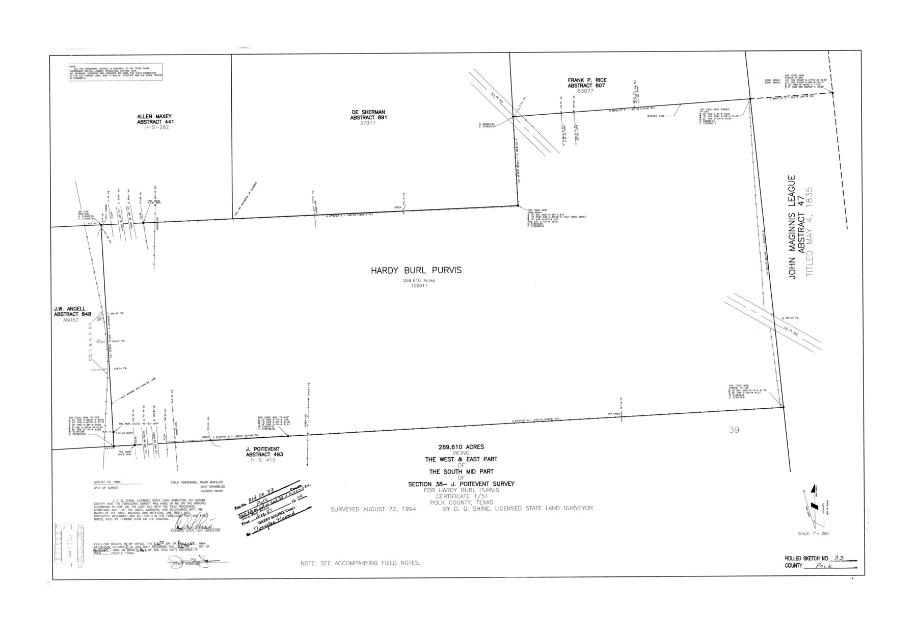
Polk County Rolled Sketch 33
269.610 acres being the west & east part of the south mid part of section 38 - J. Poitevent survey for Hardy Burl Purvis certificate 1/51, Polk County, Texas
-
Map/Doc
7319
-
Collection
General Map Collection
-
Object Dates
1994/8/22 (Survey Date)
1994/8/27 (File Date)
-
People and Organizations
D.D. Shine (Surveyor/Engineer)
David Wheeler (Chainman/Field Personnel)
Alan Chambliss (Chainman/Field Personnel)
Carmen Anaya (Chainman/Field Personnel)
-
Counties
Polk
-
Subjects
Surveying Rolled Sketch
-
Height x Width
26.5 x 38.5 inches
67.3 x 97.8 cm
-
Medium
mylar, print
-
Scale
1" = 200 feet
-
Comments
See Polk County Sketch File 45 (34376) for report.
Related maps
Polk County Sketch File 45

Print $4.00
- Digital $50.00
Polk County Sketch File 45
Size 11.3 x 8.8 inches
Map/Doc 34376
Part of: General Map Collection
Reagan County Rolled Sketch 29B

Print $20.00
- Digital $50.00
Reagan County Rolled Sketch 29B
1955
Size 36.5 x 36.1 inches
Map/Doc 9826
Navarro County Sketch File 5

Print $6.00
- Digital $50.00
Navarro County Sketch File 5
1852
Size 5.5 x 8.1 inches
Map/Doc 32307
Angelina County Sketch File 18

Print $4.00
- Digital $50.00
Angelina County Sketch File 18
Size 8.6 x 3.9 inches
Map/Doc 13028
Copy of Surveyor's Field Book, Morris Browning - In Blocks 7, 5 & 4, I&GNRRCo., Hutchinson and Carson Counties, Texas

Print $2.00
- Digital $50.00
Copy of Surveyor's Field Book, Morris Browning - In Blocks 7, 5 & 4, I&GNRRCo., Hutchinson and Carson Counties, Texas
1888
Size 8.9 x 7.1 inches
Map/Doc 62287
[Surveys in Austin's Colony along the Brazos River]
![164, [Surveys in Austin's Colony along the Brazos River], General Map Collection](https://historictexasmaps.com/wmedia_w700/maps/164.tif.jpg)
Print $20.00
- Digital $50.00
[Surveys in Austin's Colony along the Brazos River]
1833
Size 25.0 x 23.9 inches
Map/Doc 164
Borden County Rolled Sketch 8

Print $20.00
- Digital $50.00
Borden County Rolled Sketch 8
1951
Size 23.8 x 28.6 inches
Map/Doc 5159
Flight Mission No. DQO-8K, Frame 90, Galveston County

Print $20.00
- Digital $50.00
Flight Mission No. DQO-8K, Frame 90, Galveston County
1952
Size 17.9 x 22.3 inches
Map/Doc 85192
Zapata County Boundary File 1

Print $2.00
- Digital $50.00
Zapata County Boundary File 1
Size 11.4 x 9.0 inches
Map/Doc 60227
Henderson County Working Sketch 41

Print $20.00
- Digital $50.00
Henderson County Working Sketch 41
1985
Size 28.8 x 17.0 inches
Map/Doc 66174
Pecos County Sketch File 96

Print $40.00
- Digital $50.00
Pecos County Sketch File 96
1957
Size 22.4 x 8.7 inches
Map/Doc 33998
Jefferson County Working Sketch 17

Print $20.00
- Digital $50.00
Jefferson County Working Sketch 17
1954
Size 47.1 x 30.3 inches
Map/Doc 66560
Flight Mission No. BRE-1P, Frame 153, Nueces County

Print $20.00
- Digital $50.00
Flight Mission No. BRE-1P, Frame 153, Nueces County
1956
Size 18.5 x 22.5 inches
Map/Doc 86714
You may also like
Dickens County

Print $20.00
- Digital $50.00
Dickens County
1915
Size 42.2 x 39.0 inches
Map/Doc 66805
Upshur County Sketch File 21

Print $78.00
- Digital $50.00
Upshur County Sketch File 21
2000
Size 36.6 x 24.9 inches
Map/Doc 12508
Flight Mission No. CRK-8P, Frame 123, Refugio County

Print $20.00
- Digital $50.00
Flight Mission No. CRK-8P, Frame 123, Refugio County
1956
Size 18.4 x 22.1 inches
Map/Doc 86978
Dimmit County Working Sketch 20

Print $20.00
- Digital $50.00
Dimmit County Working Sketch 20
1948
Size 30.4 x 21.3 inches
Map/Doc 68681
[Section 34, Block 194 G. C. & S. F.]
![91671, [Section 34, Block 194 G. C. & S. F.], Twichell Survey Records](https://historictexasmaps.com/wmedia_w700/maps/91671-1.tif.jpg)
Print $2.00
- Digital $50.00
[Section 34, Block 194 G. C. & S. F.]
1927
Size 7.6 x 5.9 inches
Map/Doc 91671
[Sketch of Surveys south of League 153]
![90438, [Sketch of Surveys south of League 153], Twichell Survey Records](https://historictexasmaps.com/wmedia_w700/maps/90438-1.tif.jpg)
Print $2.00
- Digital $50.00
[Sketch of Surveys south of League 153]
Size 9.1 x 5.9 inches
Map/Doc 90438
Map of Galveston, Texas, Showing the Rebel Line of Works. Surveyed and Drawn by Order of G.L. Gillespie, Brevet Major and Chief Engr., Mil. Div. of the Gulf, Under the Direction of Lt. S.E. McGregory, Comdg. Topl. Party, by Pl. St. Vignes, Asst.

Print $20.00
Map of Galveston, Texas, Showing the Rebel Line of Works. Surveyed and Drawn by Order of G.L. Gillespie, Brevet Major and Chief Engr., Mil. Div. of the Gulf, Under the Direction of Lt. S.E. McGregory, Comdg. Topl. Party, by Pl. St. Vignes, Asst.
1861
Size 25.3 x 38.7 inches
Map/Doc 88594
Newton County Working Sketch 37

Print $20.00
- Digital $50.00
Newton County Working Sketch 37
1960
Size 31.7 x 22.7 inches
Map/Doc 71283
Goliad County Sketch File 40

Print $20.00
- Digital $50.00
Goliad County Sketch File 40
1949
Size 23.9 x 36.0 inches
Map/Doc 11572
Flight Mission No. DQN-2K, Frame 91, Calhoun County

Print $20.00
- Digital $50.00
Flight Mission No. DQN-2K, Frame 91, Calhoun County
1953
Size 18.8 x 22.4 inches
Map/Doc 84281
Flight Mission No. CRC-5R, Frame 41, Chambers County

Print $20.00
- Digital $50.00
Flight Mission No. CRC-5R, Frame 41, Chambers County
1956
Size 18.7 x 22.3 inches
Map/Doc 84960
Flight Mission No. BRA-9M, Frame 76, Jefferson County

Print $20.00
- Digital $50.00
Flight Mission No. BRA-9M, Frame 76, Jefferson County
1953
Size 18.5 x 22.5 inches
Map/Doc 85659