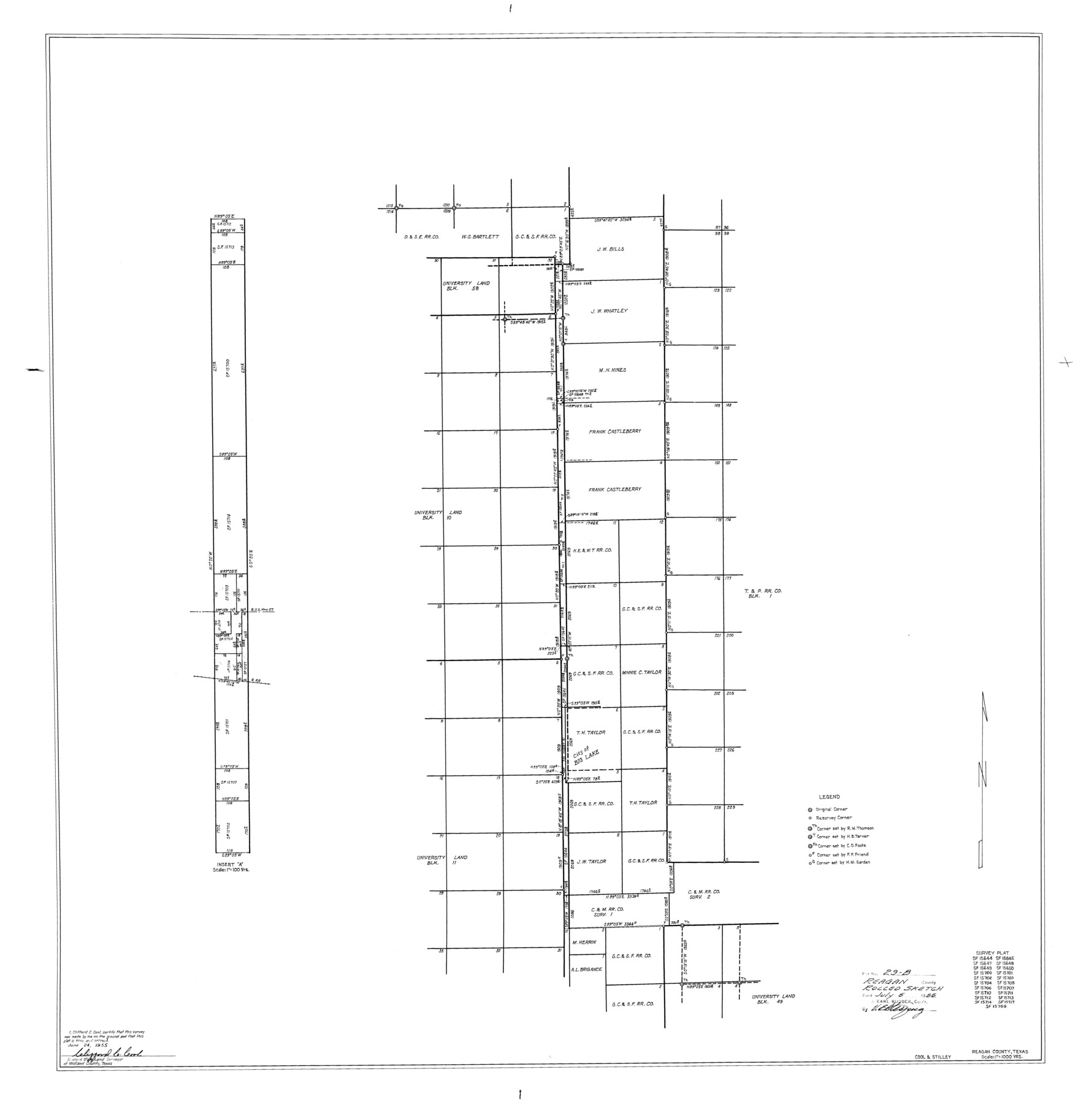
Reagan County Rolled Sketch 29B
Survey plat of SF-15644, SF-15645, SF-15647, SF-15648, SF-15649, SF-15650, SF-15700, SF-15701, SF-15702, SF-15703, SF-15704, SF-15705, SF-15706, SF-15707, SF-15710, SF-15711, SF-15712, SF-15713, SF-15714, SF-15727, SF-15769
-
Map/Doc
9826
-
Collection
General Map Collection
-
Object Dates
1955/6/24 (Creation Date)
1955/7/5 (File Date)
-
People and Organizations
Clifford C. Cool (Surveyor/Engineer)
-
Counties
Reagan
-
Subjects
Surveying Rolled Sketch
-
Height x Width
36.5 x 36.1 inches
92.7 x 91.7 cm
-
Scale
1" = 1000 varas
Part of: General Map Collection
Crockett County Sketch File 56

Print $20.00
- Digital $50.00
Crockett County Sketch File 56
Size 19.6 x 19.0 inches
Map/Doc 11224
Harrison County

Print $20.00
- Digital $50.00
Harrison County
1920
Size 45.1 x 41.8 inches
Map/Doc 1850
Map of Bexar County

Print $40.00
- Digital $50.00
Map of Bexar County
1845
Size 48.8 x 43.0 inches
Map/Doc 87237
Galveston County Sketch File 4

Print $6.00
- Digital $50.00
Galveston County Sketch File 4
1850
Size 12.8 x 8.0 inches
Map/Doc 23355

Gulf Intracoastal Waterway - Aransas Bay to Corpus Christi Bay - Modified Route Main Channel

Print $20.00
- Digital $50.00
Gulf Intracoastal Waterway - Aransas Bay to Corpus Christi Bay - Modified Route Main Channel
1960
Size 30.9 x 42.8 inches
Map/Doc 61900
McCulloch County Sketch File 2

Print $4.00
- Digital $50.00
McCulloch County Sketch File 2
1872
Size 12.8 x 8.1 inches
Map/Doc 31167
Smith County Rolled Sketch 6D1

Print $20.00
- Digital $50.00
Smith County Rolled Sketch 6D1
Size 24.7 x 24.7 inches
Map/Doc 10703
DeWitt County Sketch File 12

Print $6.00
- Digital $50.00
DeWitt County Sketch File 12
1838
Size 10.3 x 8.2 inches
Map/Doc 20821
Topographical Map of the Rio Grande, Sheet No. 18

Print $20.00
- Digital $50.00
Topographical Map of the Rio Grande, Sheet No. 18
1912
Map/Doc 89542

Terrell County Working Sketch 19

Print $20.00
- Digital $50.00
Terrell County Working Sketch 19
1932
Size 18.8 x 25.7 inches
Map/Doc 62169
You may also like
Hardin County Sketch File 58

Print $6.00
- Digital $50.00
Hardin County Sketch File 58
1929
Size 14.3 x 11.5 inches
Map/Doc 25230
Johnson County

Print $20.00
- Digital $50.00
Johnson County
1943
Size 42.0 x 38.8 inches
Map/Doc 73199
Marion County Working Sketch 16

Print $20.00
- Digital $50.00
Marion County Working Sketch 16
1954
Size 22.6 x 25.4 inches
Map/Doc 70792
Coleman County Sketch File 48

Print $29.00
- Digital $50.00
Coleman County Sketch File 48
1898
Size 8.2 x 12.7 inches
Map/Doc 18799
Presidio County Sketch File 84

Print $20.00
- Digital $50.00
Presidio County Sketch File 84
1949
Size 15.2 x 37.2 inches
Map/Doc 11723
Harris County Rolled Sketch 33

Print $20.00
- Digital $50.00
Harris County Rolled Sketch 33
1912
Size 26.0 x 34.5 inches
Map/Doc 6097
Jacob Kuechler's Field Notes (Field Book), Texas & Pacific Ry. Co. 80 Mile Reserve

Print $222.00
- Digital $50.00
Jacob Kuechler's Field Notes (Field Book), Texas & Pacific Ry. Co. 80 Mile Reserve
1879
Size 7.9 x 5.4 inches
Map/Doc 3050

[Office Sketch Showing George Tenille Grant, Brazoria County, Texas]
![75831, [Office Sketch Showing George Tenille Grant, Brazoria County, Texas], Maddox Collection](https://historictexasmaps.com/wmedia_w700/maps/75831.tif.jpg)
Print $20.00
- Digital $50.00
[Office Sketch Showing George Tenille Grant, Brazoria County, Texas]
Size 38.1 x 28.7 inches
Map/Doc 75831
Sherman County Sketch File 2

Print $20.00
- Digital $50.00
Sherman County Sketch File 2
Size 19.5 x 36.3 inches
Map/Doc 12323
List of County School Lands

Print $20.00
- Digital $50.00
List of County School Lands
Size 18.4 x 23.4 inches
Map/Doc 65798
Upton County Rolled Sketch 35

Print $20.00
- Digital $50.00
Upton County Rolled Sketch 35
1951
Size 37.3 x 19.2 inches
Map/Doc 8077