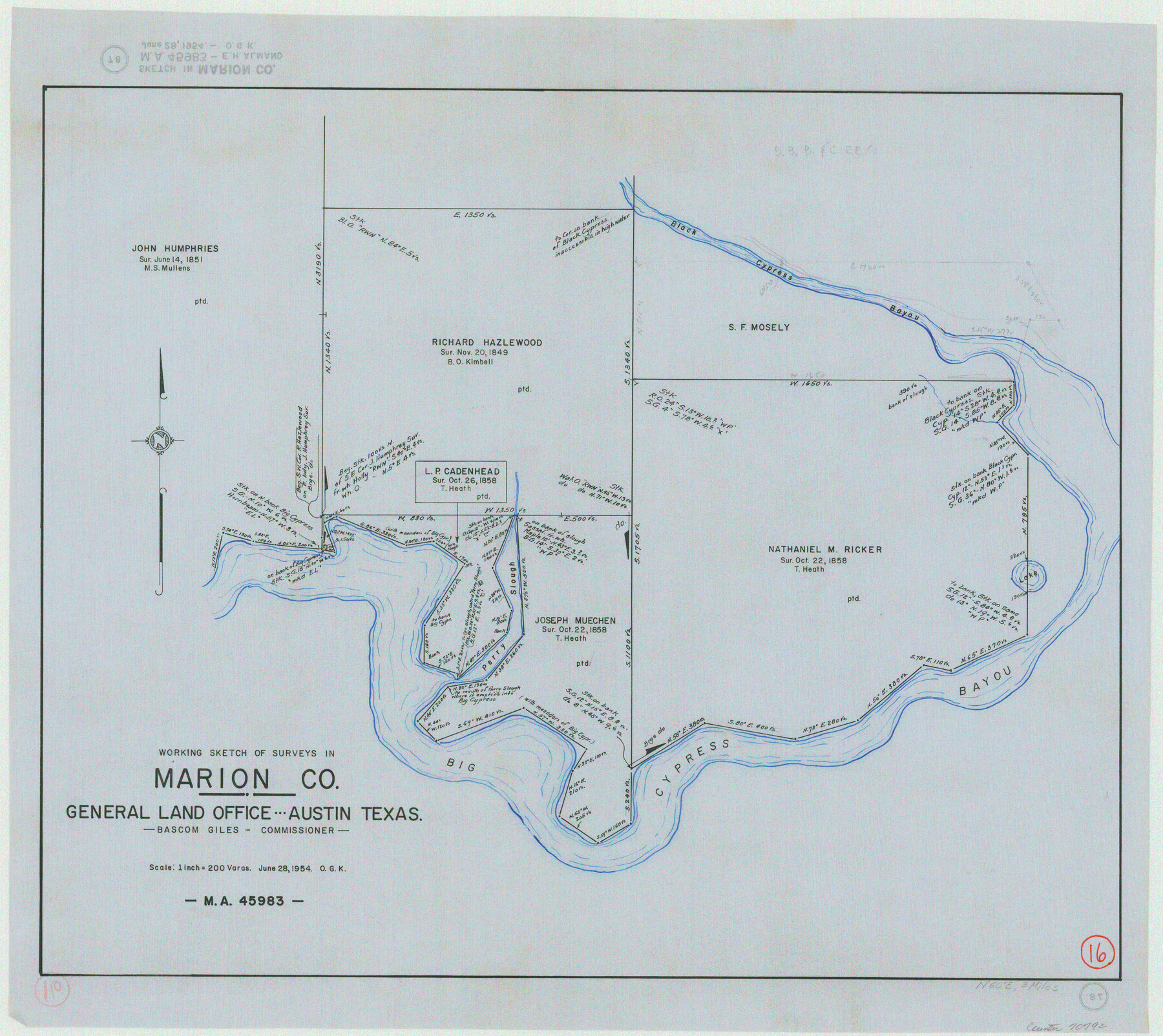
Marion County Working Sketch 16
-
Map/Doc
70792
-
Collection
General Map Collection
-
Object Dates
6/28/1954 (Creation Date)
-
People and Organizations
Otto G. Kurio (Draftsman)
-
Counties
Marion
-
Subjects
Surveying Working Sketch
-
Height x Width
22.6 x 25.4 inches
57.4 x 64.5 cm
-
Scale
1" = 200 varas
Part of: General Map Collection
Taylor County

Print $20.00
- Digital $50.00
Taylor County
1934
Size 44.8 x 39.0 inches
Map/Doc 95650
Flight Mission No. DQN-1K, Frame 109, Calhoun County

Print $20.00
- Digital $50.00
Flight Mission No. DQN-1K, Frame 109, Calhoun County
1953
Size 18.4 x 22.1 inches
Map/Doc 84176
Hardin County Working Sketch 37

Print $40.00
- Digital $50.00
Hardin County Working Sketch 37
1981
Size 68.5 x 37.4 inches
Map/Doc 63435
Cooke County Rolled Sketch 7

Print $20.00
- Digital $50.00
Cooke County Rolled Sketch 7
2002
Size 44.8 x 34.9 inches
Map/Doc 77525
Crockett County Rolled Sketch 99

Print $20.00
- Digital $50.00
Crockett County Rolled Sketch 99
Size 37.2 x 38.2 inches
Map/Doc 95401
Midland County

Print $20.00
- Digital $50.00
Midland County
1930
Size 45.9 x 39.5 inches
Map/Doc 95589
Stephens County Working Sketch 19

Print $40.00
- Digital $50.00
Stephens County Working Sketch 19
1969
Size 48.8 x 42.7 inches
Map/Doc 63962
Runnels County Sketch File 6

Print $5.00
Runnels County Sketch File 6
1872
Size 9.9 x 15.9 inches
Map/Doc 35440
Webb County Sketch File 50

Print $20.00
- Digital $50.00
Webb County Sketch File 50
1939
Size 27.4 x 18.6 inches
Map/Doc 12648
Polk County Boundary File 2

Print $8.00
- Digital $50.00
Polk County Boundary File 2
Size 14.2 x 8.7 inches
Map/Doc 57924
Bosque County Working Sketch 29

Print $20.00
- Digital $50.00
Bosque County Working Sketch 29
2009
Size 35.9 x 40.6 inches
Map/Doc 88997
Flight Mission No. BRA-7M, Frame 139, Jefferson County

Print $20.00
- Digital $50.00
Flight Mission No. BRA-7M, Frame 139, Jefferson County
1953
Size 18.7 x 22.4 inches
Map/Doc 85533
You may also like
Terrell County Working Sketch 85

Print $20.00
- Digital $50.00
Terrell County Working Sketch 85
1994
Size 31.3 x 42.8 inches
Map/Doc 69609
Flight Mission No. BRE-2P, Frame 131, Nueces County

Print $20.00
- Digital $50.00
Flight Mission No. BRE-2P, Frame 131, Nueces County
1956
Size 18.6 x 22.5 inches
Map/Doc 86804
Borden County Working Sketch 6

Print $20.00
- Digital $50.00
Borden County Working Sketch 6
1944
Size 24.6 x 23.0 inches
Map/Doc 67466
Harris County Working Sketch 36

Print $20.00
- Digital $50.00
Harris County Working Sketch 36
1938
Size 23.8 x 23.8 inches
Map/Doc 65928
Jackson County Sketch File 22

Print $10.00
- Digital $50.00
Jackson County Sketch File 22
Size 11.2 x 8.7 inches
Map/Doc 27698
Jefferson Co.

Print $40.00
- Digital $50.00
Jefferson Co.
1978
Size 48.2 x 42.7 inches
Map/Doc 73196
Harris County Rolled Sketch WB

Print $20.00
- Digital $50.00
Harris County Rolled Sketch WB
Size 15.0 x 28.5 inches
Map/Doc 6146
Northeast Part of Crockett County

Print $20.00
- Digital $50.00
Northeast Part of Crockett County
1976
Size 35.6 x 46.1 inches
Map/Doc 73120
Runnels County Working Sketch 30c

Print $20.00
- Digital $50.00
Runnels County Working Sketch 30c
1959
Size 30.5 x 32.1 inches
Map/Doc 63628
Yoakum-Terry County Sketch

Print $20.00
- Digital $50.00
Yoakum-Terry County Sketch
Size 9.6 x 27.5 inches
Map/Doc 92932
Webb County Working Sketch 15

Print $20.00
- Digital $50.00
Webb County Working Sketch 15
1923
Size 18.8 x 30.4 inches
Map/Doc 72380
[Texas Boundary Line]
![92072, [Texas Boundary Line], Twichell Survey Records](https://historictexasmaps.com/wmedia_w700/maps/92072-1.tif.jpg)
Print $20.00
- Digital $50.00
[Texas Boundary Line]
Size 21.6 x 12.9 inches
Map/Doc 92072