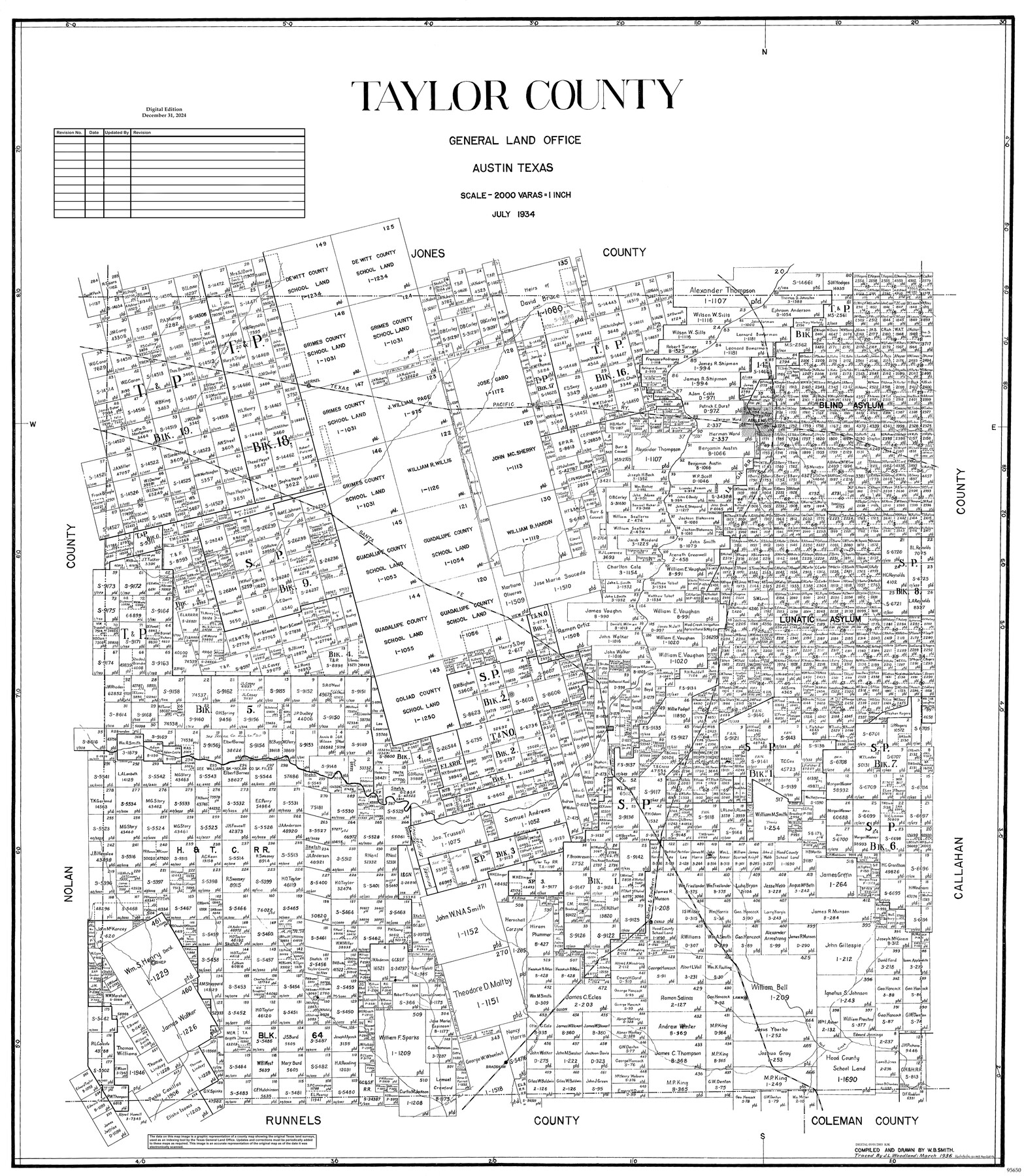
Taylor County
General Land Office Official County Map
-
Map/Doc
95650
-
Collection
General Map Collection
-
Object Dates
7/1934 (Creation Date)
12/31/2024 (Revision Date)
-
People and Organizations
W.B. Smith (Draftsman)
-
Counties
Taylor
-
Subjects
County OCM
-
Height x Width
44.8 x 39.0 inches
113.8 x 99.1 cm
-
Medium
digital image
-
Scale
1" = 2000 varas
Part of: General Map Collection
Walker County Sketch File 3

Print $4.00
- Digital $50.00
Walker County Sketch File 3
1853
Size 12.8 x 8.2 inches
Map/Doc 39551
[Surveys along the Salado and Lampasas Rivers and Saltillo Creek]
![82159, [Surveys along the Salado and Lampasas Rivers and Saltillo Creek], General Map Collection](https://historictexasmaps.com/wmedia_w700/maps/82159.tif.jpg)
Print $2.00
- Digital $50.00
[Surveys along the Salado and Lampasas Rivers and Saltillo Creek]
1845
Size 13.1 x 7.7 inches
Map/Doc 82159
Terrell County Rolled Sketch 51B

Print $20.00
- Digital $50.00
Terrell County Rolled Sketch 51B
1957
Size 23.0 x 23.8 inches
Map/Doc 7969
Upshur County Sketch File 13B

Print $20.00
- Digital $50.00
Upshur County Sketch File 13B
1936
Size 20.5 x 32.3 inches
Map/Doc 12504
Tyler County Working Sketch 4

Print $20.00
- Digital $50.00
Tyler County Working Sketch 4
1926
Size 19.4 x 35.8 inches
Map/Doc 69474
Tom Green County Rolled Sketch 12

Print $40.00
- Digital $50.00
Tom Green County Rolled Sketch 12
1951
Size 51.0 x 42.5 inches
Map/Doc 10000
Brewster County Working Sketch 114

Print $20.00
- Digital $50.00
Brewster County Working Sketch 114
1983
Size 36.0 x 31.7 inches
Map/Doc 67714
Photo Index of Texas Coast - Sheet 4 of 6

Print $20.00
- Digital $50.00
Photo Index of Texas Coast - Sheet 4 of 6
1954
Size 20.0 x 24.0 inches
Map/Doc 83442
Crockett County Sketch File 54

Print $10.00
- Digital $50.00
Crockett County Sketch File 54
1915
Size 11.3 x 8.9 inches
Map/Doc 19824
Liberty County Working Sketch 14

Print $20.00
- Digital $50.00
Liberty County Working Sketch 14
1919
Size 17.0 x 25.4 inches
Map/Doc 70473
Clay County Sketch File 26

Print $84.00
- Digital $50.00
Clay County Sketch File 26
1888
Size 14.3 x 9.0 inches
Map/Doc 18442
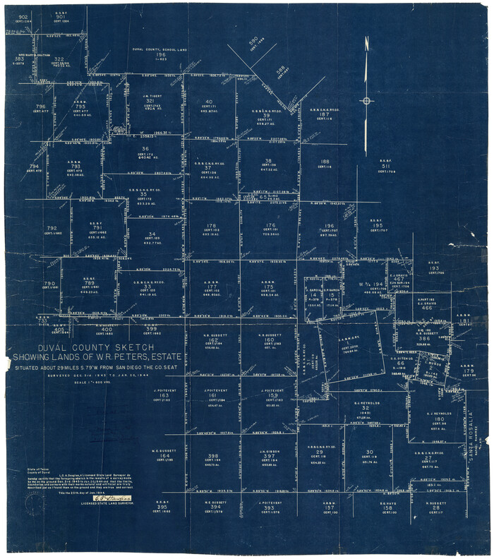
Duval County Rolled Sketch 25
Print $20.00
- Digital $50.00
Duval County Rolled Sketch 25
1944
Size 31.3 x 27.7 inches
Map/Doc 8813
You may also like
Crockett County Working Sketch 72

Print $20.00
- Digital $50.00
Crockett County Working Sketch 72
1963
Size 43.9 x 38.5 inches
Map/Doc 68405
The Rand McNally New Commercial Atlas Map of Texas

Print $20.00
- Digital $50.00
The Rand McNally New Commercial Atlas Map of Texas
1919
Size 28.4 x 40.2 inches
Map/Doc 95852
Wichita County Sketch File R

Print $8.00
- Digital $50.00
Wichita County Sketch File R
Size 14.3 x 8.8 inches
Map/Doc 40142
[Sketch of Railroad Switchyard stretching from Ross to Monroe Streets, Amarillo, Texas]
![91830, [Sketch of Railroad Switchyard stretching from Ross to Monroe Streets, Amarillo, Texas], Twichell Survey Records](https://historictexasmaps.com/wmedia_w700/maps/91830-1.tif.jpg)
Print $20.00
- Digital $50.00
[Sketch of Railroad Switchyard stretching from Ross to Monroe Streets, Amarillo, Texas]
Size 10.0 x 36.1 inches
Map/Doc 91830
[Blocks C4, S1, K and C3 in Northern Hale/Southern Swisher Counties]
![91858, [Blocks C4, S1, K and C3 in Northern Hale/Southern Swisher Counties], Twichell Survey Records](https://historictexasmaps.com/wmedia_w700/maps/91858-1.tif.jpg)
Print $2.00
- Digital $50.00
[Blocks C4, S1, K and C3 in Northern Hale/Southern Swisher Counties]
1906
Size 15.0 x 8.7 inches
Map/Doc 91858
Plat Showing Subdivision of Wilbarger County School Land Hockley County, Texas

Print $20.00
- Digital $50.00
Plat Showing Subdivision of Wilbarger County School Land Hockley County, Texas
1947
Size 20.0 x 20.9 inches
Map/Doc 92255

Webb County Working Sketch 62

Print $20.00
- Digital $50.00
Webb County Working Sketch 62
1962
Size 24.8 x 29.9 inches
Map/Doc 72428
Flight Mission No. DQN-2K, Frame 162, Calhoun County

Print $20.00
- Digital $50.00
Flight Mission No. DQN-2K, Frame 162, Calhoun County
1953
Size 18.5 x 22.2 inches
Map/Doc 84324
Sutton County Sketch File JAC

Print $20.00
- Digital $50.00
Sutton County Sketch File JAC
Size 24.5 x 23.4 inches
Map/Doc 12398
Flight Mission No. BQY-15M, Frame 22, Harris County

Print $20.00
- Digital $50.00
Flight Mission No. BQY-15M, Frame 22, Harris County
1953
Size 18.6 x 22.3 inches
Map/Doc 85320
Map of the United States engraved to illustrate Mitchell's school and family geography (Inset: Map of the Gold Region of California)

Print $20.00
- Digital $50.00
Map of the United States engraved to illustrate Mitchell's school and family geography (Inset: Map of the Gold Region of California)
1849
Size 11.8 x 17.5 inches
Map/Doc 93494