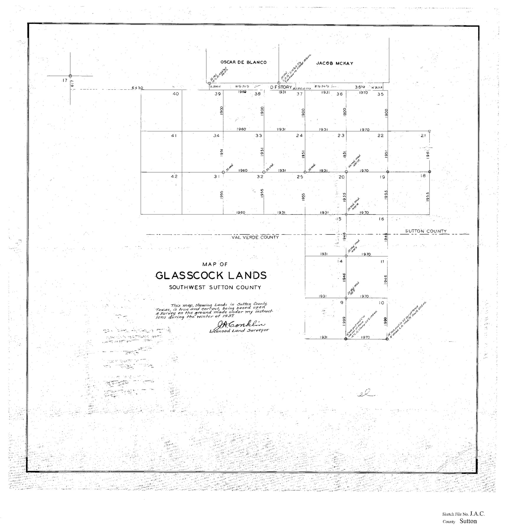
Sutton County Sketch File JAC
Map of Glasscock Lands, Southwest Sutton County, Texas
-
Map/Doc
12398
-
Collection
General Map Collection
-
Object Dates
1937 (Survey Date)
-
People and Organizations
J.A. Conklin (Surveyor/Engineer)
-
Counties
Sutton Val Verde
-
Subjects
Surveying Sketch File
-
Height x Width
24.5 x 23.4 inches
62.2 x 59.4 cm
-
Medium
paper, photocopy
Part of: General Map Collection
Gaines County Sketch File 5

Print $22.00
- Digital $50.00
Gaines County Sketch File 5
1915
Size 10.8 x 7.2 inches
Map/Doc 23177
Rusk County Working Sketch 6

Print $20.00
- Digital $50.00
Rusk County Working Sketch 6
1982
Size 32.8 x 32.9 inches
Map/Doc 63641
Flight Mission No. DQN-5K, Frame 82, Calhoun County

Print $20.00
- Digital $50.00
Flight Mission No. DQN-5K, Frame 82, Calhoun County
1953
Size 18.5 x 22.1 inches
Map/Doc 84415
Cass County Sketch File 4

Print $6.00
- Digital $50.00
Cass County Sketch File 4
1853
Size 8.2 x 11.2 inches
Map/Doc 17398
Map of the Fort Worth & Denver City Ry., Dallam County, Texas

Print $40.00
- Digital $50.00
Map of the Fort Worth & Denver City Ry., Dallam County, Texas
1887
Size 21.3 x 111.8 inches
Map/Doc 64352
Webb County Rolled Sketch 43

Print $20.00
- Digital $50.00
Webb County Rolled Sketch 43
1941
Size 25.1 x 37.6 inches
Map/Doc 8198
Panola County Working Sketch 4

Print $20.00
- Digital $50.00
Panola County Working Sketch 4
1938
Map/Doc 71413
Galveston County Sketch File 28

Print $42.00
- Digital $50.00
Galveston County Sketch File 28
1913
Size 22.2 x 5.4 inches
Map/Doc 23410
Jim Wells County Boundary File 2

Print $4.00
- Digital $50.00
Jim Wells County Boundary File 2
Size 8.7 x 11.3 inches
Map/Doc 55544
San Patricio County NRC Article 33.136 Sketch 10

Print $692.00
San Patricio County NRC Article 33.136 Sketch 10
2023
Map/Doc 97294
Culberson County Working Sketch 63

Print $20.00
- Digital $50.00
Culberson County Working Sketch 63
1975
Size 34.1 x 24.9 inches
Map/Doc 68517
Live Oak County Sketch File 34

Print $28.00
- Digital $50.00
Live Oak County Sketch File 34
1963
Size 31.0 x 23.9 inches
Map/Doc 12011
You may also like
Howard County Working Sketch 11

Print $20.00
- Digital $50.00
Howard County Working Sketch 11
1962
Size 20.5 x 20.3 inches
Map/Doc 66279
Rucker's Work on Upper Red River

Print $20.00
- Digital $50.00
Rucker's Work on Upper Red River
1857
Size 39.3 x 26.2 inches
Map/Doc 3220
McMullen County Working Sketch 39

Print $40.00
- Digital $50.00
McMullen County Working Sketch 39
1975
Size 53.3 x 31.7 inches
Map/Doc 70740
Baylor County Rolled Sketch BT

Print $20.00
- Digital $50.00
Baylor County Rolled Sketch BT
1916
Size 21.4 x 24.0 inches
Map/Doc 5131
Pecos County Sketch File 66

Print $40.00
- Digital $50.00
Pecos County Sketch File 66
Size 14.3 x 16.2 inches
Map/Doc 33826
Donley County Sketch File B7

Print $20.00
- Digital $50.00
Donley County Sketch File B7
1919
Size 25.5 x 32.4 inches
Map/Doc 11377
Blanco County Sketch File 52

Print $4.00
- Digital $50.00
Blanco County Sketch File 52
Size 11.3 x 8.9 inches
Map/Doc 76332
Wise County Boundary File 96

Print $50.00
- Digital $50.00
Wise County Boundary File 96
Size 9.2 x 3.8 inches
Map/Doc 60130
Kendall County Boundary File 3

Print $36.00
- Digital $50.00
Kendall County Boundary File 3
Size 9.4 x 37.5 inches
Map/Doc 55756
Denton County

Print $20.00
- Digital $50.00
Denton County
1947
Size 42.5 x 39.7 inches
Map/Doc 73130
Live Oak County

Print $40.00
- Digital $50.00
Live Oak County
1899
Size 50.3 x 35.3 inches
Map/Doc 16882
Saline Ranch in Mason, Kimble and Menard Counties

Print $20.00
- Digital $50.00
Saline Ranch in Mason, Kimble and Menard Counties
1916
Size 28.3 x 27.2 inches
Map/Doc 75806