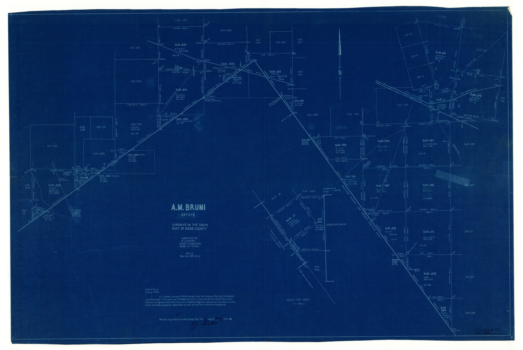
Webb County Rolled Sketch 43
A.M. Bruni estate surveys in the south part of Webb County
-
Map/Doc
8198
-
Collection
General Map Collection
-
Object Dates
1941/6/7 (File Date)
1941/5/27 (Creation Date)
-
People and Organizations
E.J. Foster (Surveyor/Engineer)
-
Counties
Webb
-
Subjects
Surveying Rolled Sketch
-
Height x Width
25.1 x 37.6 inches
63.8 x 95.5 cm
-
Medium
blueprint/diazo
-
Scale
1" = 600 varas
-
Comments
Supersedes Webb County Rolled Sketch 42 (8197).
Related maps
Webb County Rolled Sketch 42

Print $20.00
- Digital $50.00
Webb County Rolled Sketch 42
1941
Size 25.2 x 37.1 inches
Map/Doc 8197
Part of: General Map Collection
Webb County Sketch File 50

Print $20.00
- Digital $50.00
Webb County Sketch File 50
1939
Size 27.4 x 18.6 inches
Map/Doc 12648
Harris County Sketch File 66

Print $20.00
- Digital $50.00
Harris County Sketch File 66
Size 16.9 x 27.5 inches
Map/Doc 11661
Sectional Map No. 2 of the lands and the line of the Texas & Pacific Ry. Co. in Howard, Martin, Andrews, Midland and Tom Green Counties

Print $20.00
- Digital $50.00
Sectional Map No. 2 of the lands and the line of the Texas & Pacific Ry. Co. in Howard, Martin, Andrews, Midland and Tom Green Counties
1885
Size 18.9 x 23.2 inches
Map/Doc 4861
Flight Mission No. DAG-18K, Frame 179, Matagorda County

Print $20.00
- Digital $50.00
Flight Mission No. DAG-18K, Frame 179, Matagorda County
1952
Size 16.2 x 16.0 inches
Map/Doc 86371
Flight Mission No. DQN-2K, Frame 71, Calhoun County

Print $20.00
- Digital $50.00
Flight Mission No. DQN-2K, Frame 71, Calhoun County
1953
Size 18.9 x 22.4 inches
Map/Doc 84263
Harris County Sketch File 84

Print $20.00
- Digital $50.00
Harris County Sketch File 84
1950
Size 23.1 x 35.7 inches
Map/Doc 11672
Fisher County Working Sketch Graphic Index

Print $20.00
- Digital $50.00
Fisher County Working Sketch Graphic Index
1944
Size 46.9 x 41.4 inches
Map/Doc 76542
Hutchinson County Sketch File 28

Print $6.00
- Digital $50.00
Hutchinson County Sketch File 28
1926
Size 11.3 x 8.8 inches
Map/Doc 27261
Lampasas County Boundary File 9

Print $6.00
- Digital $50.00
Lampasas County Boundary File 9
Size 11.2 x 8.7 inches
Map/Doc 56181
Gulf Intracoastal Waterway - Aransas Bay to Corpus Christi Bay - Modified Route Main Channel

Print $20.00
- Digital $50.00
Gulf Intracoastal Waterway - Aransas Bay to Corpus Christi Bay - Modified Route Main Channel
1960
Size 31.0 x 42.7 inches
Map/Doc 61901
United States - Gulf Coast - Galveston to Rio Grande

Print $20.00
- Digital $50.00
United States - Gulf Coast - Galveston to Rio Grande
1919
Size 26.7 x 18.2 inches
Map/Doc 72744
Bastrop County Rolled Sketch 1

Print $20.00
- Digital $50.00
Bastrop County Rolled Sketch 1
Size 30.0 x 23.9 inches
Map/Doc 5121
You may also like
[Map of the City of South Padre Island]
![3212, [Map of the City of South Padre Island], General Map Collection](https://historictexasmaps.com/wmedia_w700/maps/3212-1.tif.jpg)
Print $20.00
- Digital $50.00
[Map of the City of South Padre Island]
1993
Size 12.5 x 36.5 inches
Map/Doc 3212
Right of Way and Track Map International & Gt Northern Ry. operated by the International & Gt. Northern Ry. Co., San Antonio Division

Print $40.00
- Digital $50.00
Right of Way and Track Map International & Gt Northern Ry. operated by the International & Gt. Northern Ry. Co., San Antonio Division
1917
Size 25.5 x 57.8 inches
Map/Doc 64789
English Field Notes of the Spanish Archives - Book 11

English Field Notes of the Spanish Archives - Book 11
1832
Map/Doc 96537
Rusk County Sketch File 43

Print $20.00
Rusk County Sketch File 43
1951
Size 23.5 x 26.6 inches
Map/Doc 12278
Flight Mission No. CLL-1N, Frame 157, Willacy County

Print $20.00
- Digital $50.00
Flight Mission No. CLL-1N, Frame 157, Willacy County
1954
Size 18.3 x 22.0 inches
Map/Doc 87048
Jefferson County Rolled Sketch 36

Print $20.00
- Digital $50.00
Jefferson County Rolled Sketch 36
1957
Size 41.1 x 29.1 inches
Map/Doc 6395
Liberty County Working Sketch Graphic Index - east part

Print $20.00
- Digital $50.00
Liberty County Working Sketch Graphic Index - east part
1977
Size 46.0 x 34.5 inches
Map/Doc 76620
Atascosa County Sketch File 25

Print $4.00
- Digital $50.00
Atascosa County Sketch File 25
Size 12.7 x 8.0 inches
Map/Doc 13792
Ector County Boundary File 1

Print $10.00
- Digital $50.00
Ector County Boundary File 1
Size 13.3 x 8.4 inches
Map/Doc 52829

Concho County Sketch File 8 1/4

Print $20.00
- Digital $50.00
Concho County Sketch File 8 1/4
Size 23.4 x 15.0 inches
Map/Doc 11149
Gonzales County Sketch File 12

Print $4.00
- Digital $50.00
Gonzales County Sketch File 12
Size 10.8 x 8.7 inches
Map/Doc 24394