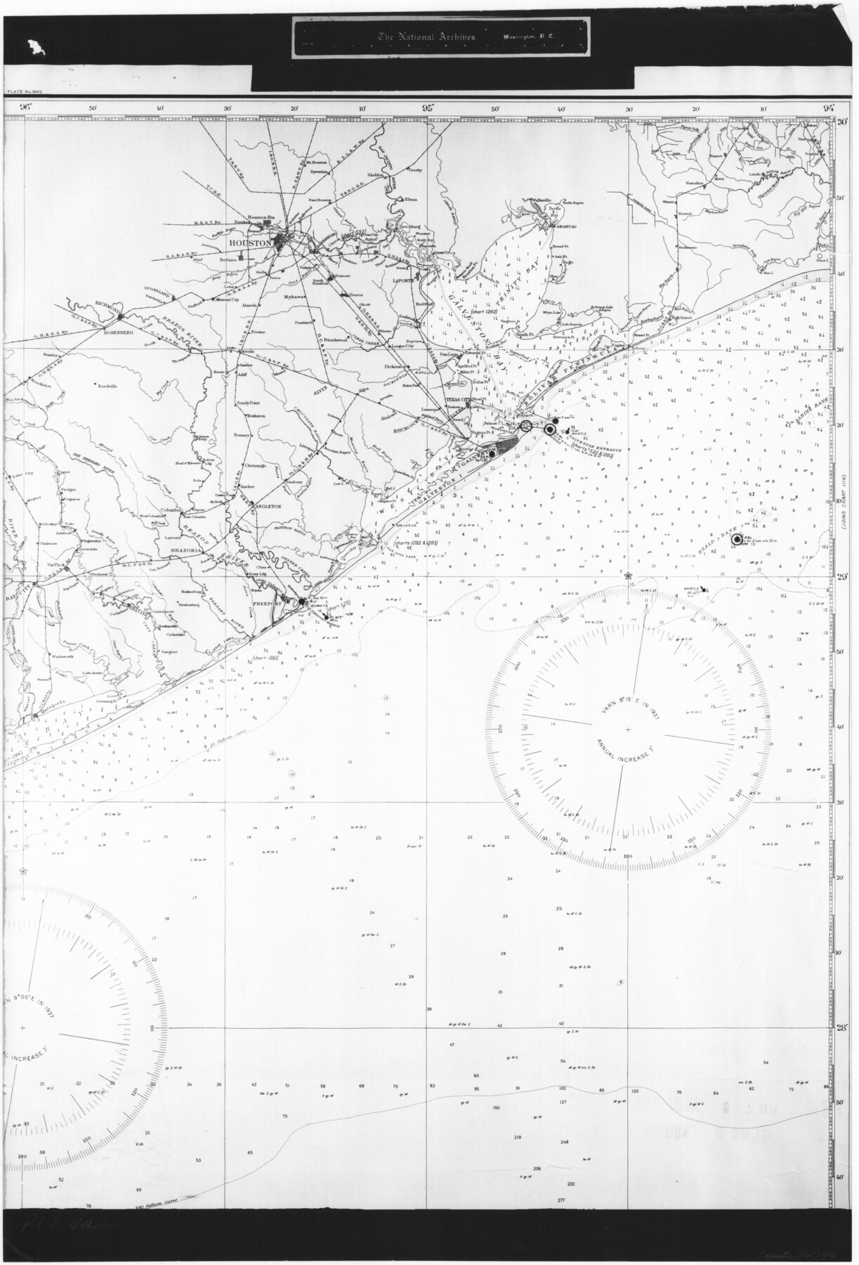
United States - Gulf Coast - Galveston to Rio Grande
RL-2-4a
-
Map/Doc
72744
-
Collection
General Map Collection
-
Object Dates
1919 (Creation Date)
-
People and Organizations
U. S. Coast and Geodetic Survey (Publisher)
-
Subjects
Nautical Charts
-
Height x Width
26.7 x 18.2 inches
67.8 x 46.2 cm
-
Comments
B/W photostat copy from National Archives in multiple pieces.
Part of: General Map Collection
Anderson County Rolled Sketch 12

Print $20.00
- Digital $50.00
Anderson County Rolled Sketch 12
1954
Size 24.6 x 21.3 inches
Map/Doc 77157
Liberty County Working Sketch 79

Print $40.00
- Digital $50.00
Liberty County Working Sketch 79
1981
Size 63.7 x 41.4 inches
Map/Doc 70539
Padre Island Under Six Flags

Print $40.00
- Digital $50.00
Padre Island Under Six Flags
1962
Size 63.7 x 36.9 inches
Map/Doc 3126
Duval County Rolled Sketch 48

Print $20.00
- Digital $50.00
Duval County Rolled Sketch 48
Size 21.8 x 18.5 inches
Map/Doc 5762

Kleberg County Rolled Sketch 10-23

Print $20.00
- Digital $50.00
Kleberg County Rolled Sketch 10-23
1953
Size 37.5 x 31.3 inches
Map/Doc 9396
Comanche County Sketch File 14

Print $4.00
- Digital $50.00
Comanche County Sketch File 14
1859
Size 8.4 x 12.9 inches
Map/Doc 19078
Bailey County Sketch File 2

Print $40.00
- Digital $50.00
Bailey County Sketch File 2
1892
Size 28.0 x 23.6 inches
Map/Doc 10881
Kinney County Working Sketch 58

Print $20.00
- Digital $50.00
Kinney County Working Sketch 58
1996
Size 36.1 x 31.7 inches
Map/Doc 70240
Wharton County Working Sketch 10

Print $20.00
- Digital $50.00
Wharton County Working Sketch 10
1980
Size 23.6 x 18.7 inches
Map/Doc 72474
Brewster County Rolled Sketch 38A

Print $20.00
- Digital $50.00
Brewster County Rolled Sketch 38A
Size 15.6 x 14.1 inches
Map/Doc 5219
Webb County Working Sketch 97

Print $20.00
- Digital $50.00
Webb County Working Sketch 97
1994
Size 27.1 x 30.6 inches
Map/Doc 72464
You may also like
Crockett County Working Sketch 62

Print $40.00
- Digital $50.00
Crockett County Working Sketch 62
1956
Size 121.8 x 37.1 inches
Map/Doc 68395
Jeff Davis County Sketch File 38

Print $8.00
- Digital $50.00
Jeff Davis County Sketch File 38
1952
Size 14.3 x 9.1 inches
Map/Doc 28054
Upshur County Working Sketch 13

Print $20.00
- Digital $50.00
Upshur County Working Sketch 13
1992
Size 29.7 x 42.5 inches
Map/Doc 69570
Taylor County Sketch File 8

Print $16.00
- Digital $50.00
Taylor County Sketch File 8
1879
Size 13.9 x 8.7 inches
Map/Doc 37784
Graham's Addition Being a Subdivision of a Portion of Lot No. 1 of Spear League

Print $20.00
- Digital $50.00
Graham's Addition Being a Subdivision of a Portion of Lot No. 1 of Spear League
1914
Size 13.6 x 33.0 inches
Map/Doc 542
Runnels County Rolled Sketch 28

Print $20.00
- Digital $50.00
Runnels County Rolled Sketch 28
1928
Size 19.8 x 39.4 inches
Map/Doc 7516
East Part of Liberty Co.

Print $20.00
- Digital $50.00
East Part of Liberty Co.
1977
Size 41.0 x 30.9 inches
Map/Doc 77352
Kimble County Rolled Sketch 28

Print $20.00
- Digital $50.00
Kimble County Rolled Sketch 28
1964
Size 19.7 x 20.6 inches
Map/Doc 6518
Tom Green County Rolled Sketch 19

Print $20.00
- Digital $50.00
Tom Green County Rolled Sketch 19
1959
Size 35.0 x 32.1 inches
Map/Doc 8002
Rusk County Sketch File 17

Print $22.00
Rusk County Sketch File 17
1857
Size 12.7 x 15.7 inches
Map/Doc 35520
MKT (Missouri Kansas Texas) Katy Railroad Time Tables

Print $54.00
- Digital $50.00
MKT (Missouri Kansas Texas) Katy Railroad Time Tables
1946
Size 9.3 x 16.4 inches
Map/Doc 93981
Guadalupe County Sketch File 22

Print $20.00
- Digital $50.00
Guadalupe County Sketch File 22
1957
Size 16.2 x 16.5 inches
Map/Doc 11591