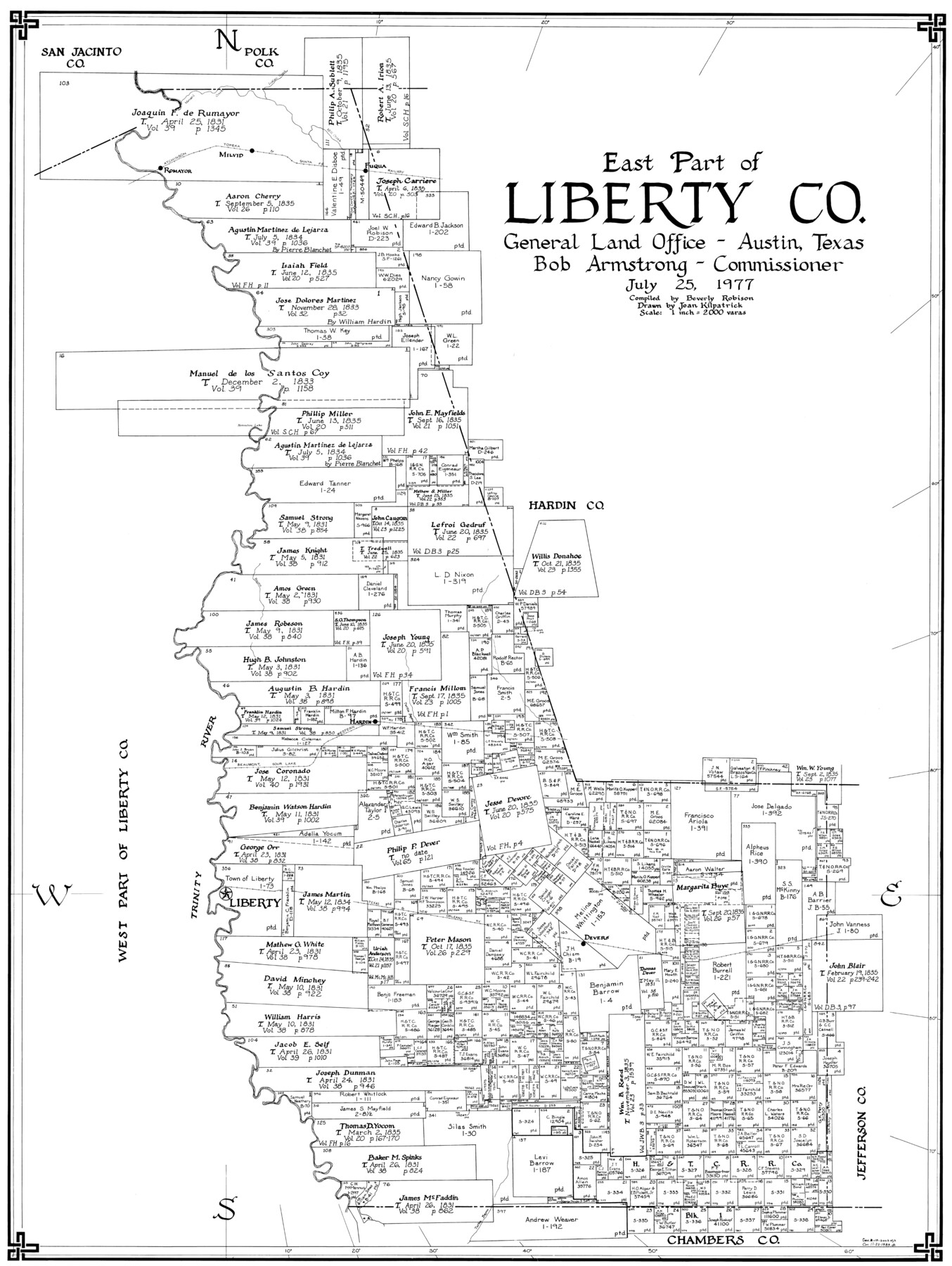
East Part of Liberty Co.
-
Map/Doc
77352
-
Collection
General Map Collection
-
Object Dates
7/25/1977 (Creation Date)
-
People and Organizations
Beverly Robison (Compiler)
Joan Kilpatrick (Draftsman)
-
Counties
Liberty
-
Subjects
County
-
Height x Width
41.0 x 30.9 inches
104.1 x 78.5 cm
-
Scale
1" = 2000 varas
Part of: General Map Collection
Potter County Boundary File 3b

Print $12.00
- Digital $50.00
Potter County Boundary File 3b
Size 9.8 x 6.4 inches
Map/Doc 57979
San Patricio County Sketch File 36

Print $26.00
- Digital $50.00
San Patricio County Sketch File 36
1940
Size 11.3 x 8.7 inches
Map/Doc 36129
Aransas County Rolled Sketch 7

Print $437.00
- Digital $50.00
Aransas County Rolled Sketch 7
Map/Doc 42081
Kendall County Working Sketch 11

Print $20.00
- Digital $50.00
Kendall County Working Sketch 11
1954
Size 34.0 x 24.8 inches
Map/Doc 66683
Cameron County Rolled Sketch 27

Print $20.00
- Digital $50.00
Cameron County Rolled Sketch 27
Size 19.0 x 39.5 inches
Map/Doc 5392
Harbor Pass and Bar at Brazos Santiago, Texas

Print $20.00
- Digital $50.00
Harbor Pass and Bar at Brazos Santiago, Texas
1871
Size 26.8 x 18.3 inches
Map/Doc 72984
Travis County Working Sketch 10

Print $20.00
- Digital $50.00
Travis County Working Sketch 10
1918
Size 24.7 x 16.3 inches
Map/Doc 69394
Reeves County Working Sketch 12

Print $20.00
- Digital $50.00
Reeves County Working Sketch 12
1958
Size 34.2 x 24.5 inches
Map/Doc 63455
Leon County Sketch File 33

Print $6.00
- Digital $50.00
Leon County Sketch File 33
1955
Size 14.2 x 9.7 inches
Map/Doc 29834
Cass County Working Sketch 1

Print $20.00
- Digital $50.00
Cass County Working Sketch 1
Size 20.2 x 21.9 inches
Map/Doc 67904
Pecos County Sketch File 114

Print $18.00
- Digital $50.00
Pecos County Sketch File 114
1912
Size 13.3 x 8.9 inches
Map/Doc 34074
Howard County Working Sketch 7a

Print $40.00
- Digital $50.00
Howard County Working Sketch 7a
1950
Size 81.9 x 24.7 inches
Map/Doc 66273
You may also like
Amistad International Reservoir on Rio Grande 63

Print $20.00
- Digital $50.00
Amistad International Reservoir on Rio Grande 63
1949
Size 28.2 x 39.5 inches
Map/Doc 73348
Val Verde County Working Sketch 105

Print $20.00
- Digital $50.00
Val Verde County Working Sketch 105
1983
Size 39.8 x 43.0 inches
Map/Doc 72240


Pecos County Rolled Sketch 69

Print $20.00
- Digital $50.00
Pecos County Rolled Sketch 69
Size 37.9 x 33.8 inches
Map/Doc 9701
Flight Mission No. DQN-6K, Frame 14, Calhoun County

Print $20.00
- Digital $50.00
Flight Mission No. DQN-6K, Frame 14, Calhoun County
1953
Size 18.4 x 22.2 inches
Map/Doc 84436
Flight Mission No. BRA-9M, Frame 64, Jefferson County

Print $20.00
- Digital $50.00
Flight Mission No. BRA-9M, Frame 64, Jefferson County
1953
Size 18.6 x 22.4 inches
Map/Doc 85647
Hunt County Sketch File 39

Print $8.00
- Digital $50.00
Hunt County Sketch File 39
1922
Size 14.3 x 8.8 inches
Map/Doc 27159
Karnes County Sketch File 1

Print $4.00
- Digital $50.00
Karnes County Sketch File 1
Size 8.8 x 10.7 inches
Map/Doc 28545
Newton County Working Sketch 29

Print $20.00
- Digital $50.00
Newton County Working Sketch 29
1955
Size 21.2 x 39.8 inches
Map/Doc 71275
Flight Mission No. BRA-3M, Frame 119, Jefferson County

Print $20.00
- Digital $50.00
Flight Mission No. BRA-3M, Frame 119, Jefferson County
1953
Size 18.5 x 22.2 inches
Map/Doc 85393
[Coastal Chart of Galveston Island, Bolivar Peninsula and Galveston Bay]
![61804, [Coastal Chart of Galveston Island, Bolivar Peninsula and Galveston Bay], General Map Collection](https://historictexasmaps.com/wmedia_w700/maps/61804.tif.jpg)
Print $20.00
- Digital $50.00
[Coastal Chart of Galveston Island, Bolivar Peninsula and Galveston Bay]
Size 24.0 x 18.1 inches
Map/Doc 61804