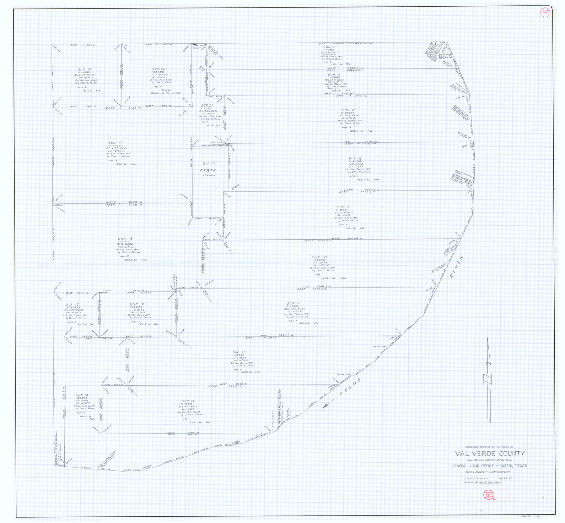
Val Verde County Working Sketch 105
-
Map/Doc
72240
-
Collection
General Map Collection
-
Object Dates
1/4/1983 (Creation Date)
-
People and Organizations
Elisandro Leos (Draftsman)
-
Counties
Val Verde
-
Subjects
Surveying Working Sketch
-
Height x Width
39.8 x 43.0 inches
101.1 x 109.2 cm
-
Scale
1" = 200 varas
Part of: General Map Collection
Flight Mission No. CRE-2R, Frame 87, Jackson County

Print $20.00
- Digital $50.00
Flight Mission No. CRE-2R, Frame 87, Jackson County
1956
Size 18.5 x 22.3 inches
Map/Doc 85359
Lamar County Sketch File 3

Print $6.00
- Digital $50.00
Lamar County Sketch File 3
1864
Size 14.2 x 8.6 inches
Map/Doc 29275
Harris County Sketch File 71a

Print $24.00
- Digital $50.00
Harris County Sketch File 71a
1941
Size 11.4 x 8.9 inches
Map/Doc 25525
Brazoria County Sketch File 22

Print $4.00
- Digital $50.00
Brazoria County Sketch File 22
Size 9.6 x 8.4 inches
Map/Doc 15018
Colorado River, Willow Creek Valley Sheet[/Near Kirtley, Texas Mapped in Cooperation with Commissioner's Court of Fayette Co.]
![65322, Colorado River, Willow Creek Valley Sheet[/Near Kirtley, Texas Mapped in Cooperation with Commissioner's Court of Fayette Co.], General Map Collection](https://historictexasmaps.com/wmedia_w700/maps/65322.tif.jpg)
Print $20.00
- Digital $50.00
Colorado River, Willow Creek Valley Sheet[/Near Kirtley, Texas Mapped in Cooperation with Commissioner's Court of Fayette Co.]
1938
Size 38.2 x 40.8 inches
Map/Doc 65322
La Salle County Sketch File 24

Print $4.00
- Digital $50.00
La Salle County Sketch File 24
1877
Size 9.2 x 6.1 inches
Map/Doc 29547
Flight Mission No. CRK-7P, Frame 81, Refugio County

Print $20.00
- Digital $50.00
Flight Mission No. CRK-7P, Frame 81, Refugio County
1956
Size 18.4 x 22.1 inches
Map/Doc 86952
Cooke County Working Sketch 33

Print $20.00
- Digital $50.00
Cooke County Working Sketch 33
1984
Size 25.6 x 28.6 inches
Map/Doc 68270
Smith County Sketch File 2

Print $4.00
- Digital $50.00
Smith County Sketch File 2
1853
Size 12.7 x 8.5 inches
Map/Doc 36748
Nueces County Rolled Sketch 76

Print $20.00
- Digital $50.00
Nueces County Rolled Sketch 76
1981
Size 18.3 x 23.6 inches
Map/Doc 6937
[Map of Val Verde County]
![4110, [Map of Val Verde County], General Map Collection](https://historictexasmaps.com/wmedia_w700/maps/4110-1.tif.jpg)
Print $20.00
- Digital $50.00
[Map of Val Verde County]
1931
Size 36.4 x 24.1 inches
Map/Doc 4110
Travis County Working Sketch 61

Print $20.00
- Digital $50.00
Travis County Working Sketch 61
1995
Size 20.9 x 24.7 inches
Map/Doc 69445
You may also like
Matagorda County NRC Article 33.136 Sketch 1

Print $21.00
- Digital $50.00
Matagorda County NRC Article 33.136 Sketch 1
2004
Size 17.6 x 23.1 inches
Map/Doc 82920
Reeves County Sketch File 9

Print $20.00
- Digital $50.00
Reeves County Sketch File 9
Size 46.3 x 38.2 inches
Map/Doc 10587
Garza County Rolled Sketch R-2

Print $40.00
- Digital $50.00
Garza County Rolled Sketch R-2
Size 36.0 x 50.2 inches
Map/Doc 9046
Childress County Sketch File 24

Print $4.00
- Digital $50.00
Childress County Sketch File 24
1917
Size 12.9 x 8.6 inches
Map/Doc 18384
[1680 Bed of Rock 20 Feet in Diameter on East Bank of Concho Drain]
![91361, [1680 Bed of Rock 20 Feet in Diameter on East Bank of Concho Drain], Twichell Survey Records](https://historictexasmaps.com/wmedia_w700/maps/91361-1.tif.jpg)
Print $20.00
- Digital $50.00
[1680 Bed of Rock 20 Feet in Diameter on East Bank of Concho Drain]
Size 25.4 x 15.1 inches
Map/Doc 91361
Nueces County Sketch File 32

Print $32.00
- Digital $50.00
Nueces County Sketch File 32
1907
Size 14.2 x 8.7 inches
Map/Doc 32605
Kinney County Sketch File 39

Print $20.00
- Digital $50.00
Kinney County Sketch File 39
1948
Size 18.8 x 21.0 inches
Map/Doc 11951
Dallam County

Print $40.00
- Digital $50.00
Dallam County
1926
Size 40.1 x 48.6 inches
Map/Doc 73125

Hill County Sketch File 8a

Print $4.00
- Digital $50.00
Hill County Sketch File 8a
1858
Size 10.2 x 8.1 inches
Map/Doc 26474
Henderson County Working Sketch 10

Print $20.00
- Digital $50.00
Henderson County Working Sketch 10
1925
Size 29.7 x 18.8 inches
Map/Doc 66143
