Matagorda County NRC Article 33.136 Sketch 1
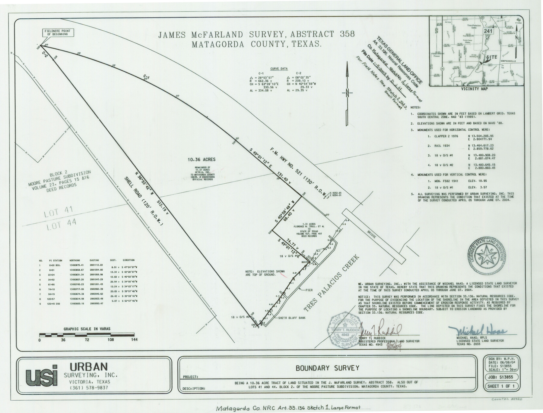
A Boundary Survey of a 10.36 Acre Tract of Land Situated in the James McFarland Survey, Abstract 358 and out of Lots 41 and 44, Block 2 of the Moore Pasture Subdivision
-
Map/Doc
82920
-
Collection
General Map Collection
-
Object Dates
2004/6/8 (Creation Date)
2005/1/5 (File Date)
-
People and Organizations
Urban Surveying, Inc. (Publisher)
Urban Surveying, Inc. (Printer)
Michael Haas (Surveyor/Engineer)
Terry T. Ruddick (Surveyor/Engineer)
W.P.H. (Compiler)
W.P.H. (Draftsman)
-
Counties
Matagorda
-
Subjects
Surveying CBS
-
Height x Width
17.6 x 23.1 inches
44.7 x 58.7 cm
-
Medium
multi-page, multi-format
-
Comments
Survey located 18 miles South 40 degrees West of Bay City, Texas.
Part of: General Map Collection
Cass County Working Sketch 20

Print $20.00
- Digital $50.00
Cass County Working Sketch 20
1960
Size 24.8 x 31.3 inches
Map/Doc 67923
Brazoria County Sketch File 10a

Print $50.00
- Digital $50.00
Brazoria County Sketch File 10a
1912
Size 7.1 x 8.7 inches
Map/Doc 14940

Crockett County Rolled Sketch 79

Print $20.00
- Digital $50.00
Crockett County Rolled Sketch 79
1954
Size 36.1 x 47.8 inches
Map/Doc 76013
Red River County Working Sketch 81-2

Print $20.00
- Digital $50.00
Red River County Working Sketch 81-2
1987
Size 14.6 x 18.6 inches
Map/Doc 72065
Comal County Working Sketch 15

Print $20.00
- Digital $50.00
Comal County Working Sketch 15
1994
Size 44.6 x 31.0 inches
Map/Doc 68181
Flight Mission No. DAG-23K, Frame 146, Matagorda County

Print $20.00
- Digital $50.00
Flight Mission No. DAG-23K, Frame 146, Matagorda County
1953
Size 17.0 x 22.4 inches
Map/Doc 86494
Archer County Sketch File 8a

Print $8.00
- Digital $50.00
Archer County Sketch File 8a
Size 8.8 x 7.1 inches
Map/Doc 13639
Duval County Rolled Sketch E

Print $20.00
- Digital $50.00
Duval County Rolled Sketch E
1935
Size 36.4 x 37.7 inches
Map/Doc 8808
Montgomery County Rolled Sketch 43

Print $20.00
- Digital $50.00
Montgomery County Rolled Sketch 43
1971
Size 32.1 x 34.3 inches
Map/Doc 6822
Bexar County State Real Property Sketch 4

Print $20.00
- Digital $50.00
Bexar County State Real Property Sketch 4
2013
Size 25.0 x 36.5 inches
Map/Doc 93692
Kinney County Working Sketch 16

Print $20.00
- Digital $50.00
Kinney County Working Sketch 16
1946
Size 46.3 x 37.7 inches
Map/Doc 70198
You may also like
Flight Mission No. DQN-2K, Frame 157, Calhoun County

Print $20.00
- Digital $50.00
Flight Mission No. DQN-2K, Frame 157, Calhoun County
1953
Size 18.5 x 22.2 inches
Map/Doc 84319
Medina County Rolled Sketch 15

Print $20.00
- Digital $50.00
Medina County Rolled Sketch 15
1980
Size 25.2 x 20.3 inches
Map/Doc 6749
Presidio County Rolled Sketch 71

Print $20.00
- Digital $50.00
Presidio County Rolled Sketch 71
1941
Size 31.7 x 42.9 inches
Map/Doc 7361
Moore County Rolled Sketch 11

Print $20.00
- Digital $50.00
Moore County Rolled Sketch 11
Size 34.1 x 43.0 inches
Map/Doc 9549
Flight Mission No. BRA-7M, Frame 39, Jefferson County

Print $20.00
- Digital $50.00
Flight Mission No. BRA-7M, Frame 39, Jefferson County
1953
Size 18.7 x 22.5 inches
Map/Doc 85490
Mason County Working Sketch 14

Print $20.00
- Digital $50.00
Mason County Working Sketch 14
1959
Size 28.6 x 23.3 inches
Map/Doc 70850
Hansford County Boundary File 1a

Print $2.00
- Digital $50.00
Hansford County Boundary File 1a
Size 11.2 x 8.8 inches
Map/Doc 54244
Jefferson County Working Sketch 34

Print $20.00
- Digital $50.00
Jefferson County Working Sketch 34
1981
Size 33.4 x 18.8 inches
Map/Doc 66578
Smith County Working Sketch 8

Print $20.00
- Digital $50.00
Smith County Working Sketch 8
1941
Size 28.9 x 22.7 inches
Map/Doc 63893
Galveston Bay Entrance, Series No. 518

Print $40.00
- Digital $50.00
Galveston Bay Entrance, Series No. 518
1971
Size 18.0 x 49.9 inches
Map/Doc 69862
Hale County Rolled Sketch 10

Print $40.00
- Digital $50.00
Hale County Rolled Sketch 10
Size 52.4 x 28.3 inches
Map/Doc 76447
Upton County Rolled Sketch 50

Print $20.00
- Digital $50.00
Upton County Rolled Sketch 50
1959
Size 20.8 x 32.7 inches
Map/Doc 8085