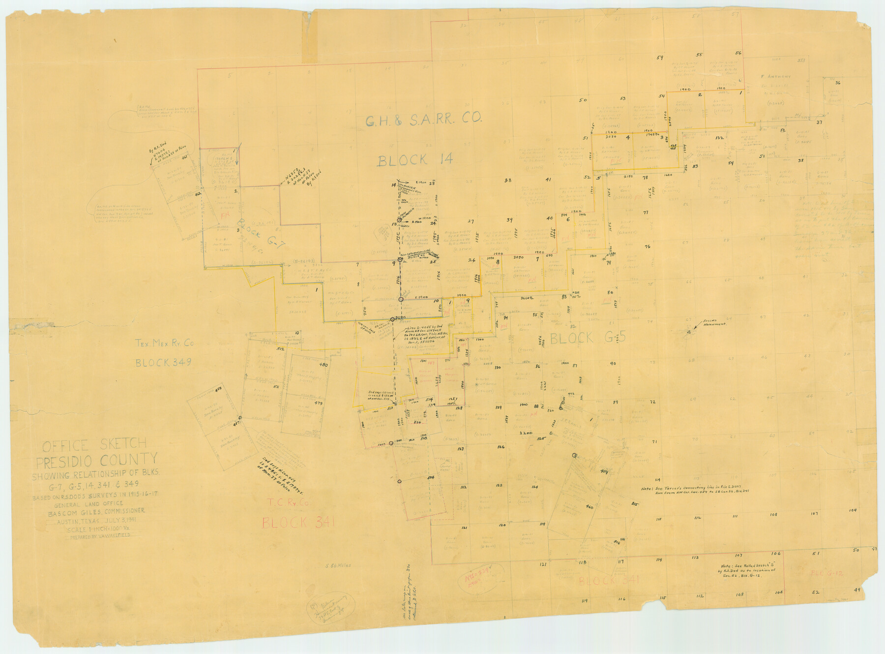
Presidio County Rolled Sketch 71
Office sketch, Presidio County showing relationship of Blks. G-7, G-5, 14, 341, & 349 based on R.S. Dod's surveys in 1915-16-17
-
Map/Doc
7361
-
Collection
General Map Collection
-
Object Dates
1941/7/3 (Creation Date)
-
People and Organizations
V.A. Wakefield (Draftsman)
-
Counties
Presidio
-
Subjects
Surveying Rolled Sketch
-
Height x Width
31.7 x 42.9 inches
80.5 x 109.0 cm
-
Medium
paper, manuscript
-
Scale
1" = 1000 varas
Part of: General Map Collection
Anderson County Sketch File 16b

Print $2.00
- Digital $50.00
Anderson County Sketch File 16b
1859
Size 7.2 x 2.9 inches
Map/Doc 12788
Burnet County Working Sketch 17

Print $20.00
- Digital $50.00
Burnet County Working Sketch 17
1979
Size 41.1 x 34.4 inches
Map/Doc 67860
Tom Green County Working Sketch 1

Print $3.00
- Digital $50.00
Tom Green County Working Sketch 1
1915
Size 11.0 x 13.8 inches
Map/Doc 69370
Crosby County Sketch File 12a

Print $20.00
- Digital $50.00
Crosby County Sketch File 12a
1901
Size 21.5 x 30.9 inches
Map/Doc 11248
Montague County Sketch File 10

Print $4.00
- Digital $50.00
Montague County Sketch File 10
1873
Size 7.9 x 11.8 inches
Map/Doc 31732
Flight Mission No. BRA-7M, Frame 197, Jefferson County

Print $20.00
- Digital $50.00
Flight Mission No. BRA-7M, Frame 197, Jefferson County
1953
Size 18.6 x 22.4 inches
Map/Doc 85565
Anderson County Working Sketch 43

Print $20.00
- Digital $50.00
Anderson County Working Sketch 43
1988
Size 37.2 x 33.9 inches
Map/Doc 67043
Kent County Working Sketch 24

Print $20.00
- Digital $50.00
Kent County Working Sketch 24
1988
Size 30.5 x 21.2 inches
Map/Doc 70031
Flight Mission No. CUG-2P, Frame 30, Kleberg County

Print $20.00
- Digital $50.00
Flight Mission No. CUG-2P, Frame 30, Kleberg County
1956
Size 18.5 x 22.4 inches
Map/Doc 86195
Stonewall County Sketch File B2

Print $20.00
- Digital $50.00
Stonewall County Sketch File B2
1902
Size 25.8 x 25.0 inches
Map/Doc 12377
Hill County Sketch File 18

Print $26.00
- Digital $50.00
Hill County Sketch File 18
1852
Size 8.6 x 4.9 inches
Map/Doc 26486
Blanco County Working Sketch 15

Print $20.00
- Digital $50.00
Blanco County Working Sketch 15
1950
Size 23.5 x 20.7 inches
Map/Doc 67375
You may also like
Jackson County

Print $40.00
- Digital $50.00
Jackson County
1920
Size 49.5 x 41.8 inches
Map/Doc 66878
[Corner of Blocks H1, K5, Z3, S, and Block 8]
![91470, [Corner of Blocks H1, K5, Z3, S, and Block 8], Twichell Survey Records](https://historictexasmaps.com/wmedia_w700/maps/91470-1.tif.jpg)
Print $3.00
- Digital $50.00
[Corner of Blocks H1, K5, Z3, S, and Block 8]
Size 11.9 x 14.6 inches
Map/Doc 91470
Flight Mission No. BQR-22K, Frame 36, Brazoria County

Print $20.00
- Digital $50.00
Flight Mission No. BQR-22K, Frame 36, Brazoria County
1953
Size 18.6 x 22.4 inches
Map/Doc 84120
Shelby County Working Sketch 2

Print $20.00
- Digital $50.00
Shelby County Working Sketch 2
Size 32.9 x 37.3 inches
Map/Doc 63855
El Paso County Working Sketch 48

Print $20.00
- Digital $50.00
El Paso County Working Sketch 48
1987
Size 32.7 x 29.4 inches
Map/Doc 69070
El Paso County Working Sketch 28

Print $20.00
- Digital $50.00
El Paso County Working Sketch 28
1966
Size 24.0 x 31.5 inches
Map/Doc 69050
Marion County Working Sketch 44

Print $20.00
- Digital $50.00
Marion County Working Sketch 44
2002
Size 42.7 x 27.0 inches
Map/Doc 78215
Flight Mission No. CRC-1R, Frame 154, Chambers County

Print $20.00
- Digital $50.00
Flight Mission No. CRC-1R, Frame 154, Chambers County
1956
Size 18.9 x 22.5 inches
Map/Doc 84716
Hardeman County Sketch File 31

Print $4.00
- Digital $50.00
Hardeman County Sketch File 31
Size 14.5 x 9.0 inches
Map/Doc 25066
Hamilton County Boundary File 1

Print $22.00
- Digital $50.00
Hamilton County Boundary File 1
Size 8.6 x 8.1 inches
Map/Doc 54183
Vacancy Application - John H. Tyler near T.C. Ry. Co. Block 1 Surveys 101, 102, 103, & 104. Letters and Maps, Pecos County

Print $279.00
- Digital $50.00
Vacancy Application - John H. Tyler near T.C. Ry. Co. Block 1 Surveys 101, 102, 103, & 104. Letters and Maps, Pecos County
1934
Size 18.1 x 21.1 inches
Map/Doc 2048
Hale County Working Sketch 4

Print $20.00
- Digital $50.00
Hale County Working Sketch 4
1979
Size 22.7 x 18.7 inches
Map/Doc 63324