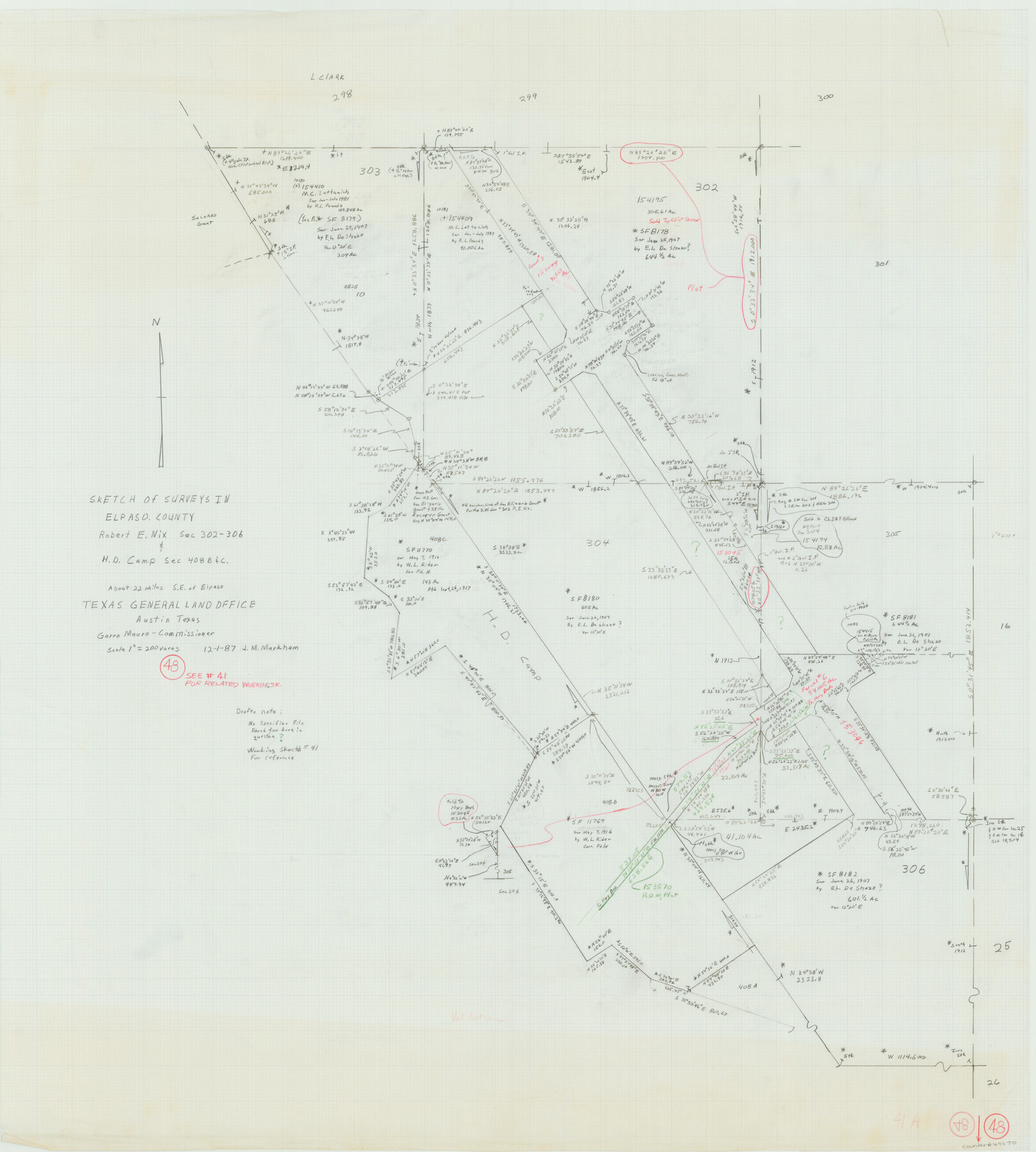
El Paso County Working Sketch 48
-
Map/Doc
69070
-
Collection
General Map Collection
-
Object Dates
12/1/1987 (Creation Date)
-
People and Organizations
J.M. Markham (Draftsman)
-
Counties
El Paso
-
Subjects
Surveying Working Sketch
-
Height x Width
32.7 x 29.4 inches
83.1 x 74.7 cm
-
Scale
1" = 200 varas
Part of: General Map Collection
Post Route Map of Texas (Inset 1: Dallas-Fort Worth Area; Inset 2: Texas Panhandle)

Print $40.00
- Digital $50.00
Post Route Map of Texas (Inset 1: Dallas-Fort Worth Area; Inset 2: Texas Panhandle)
1939
Size 56.8 x 39.2 inches
Map/Doc 93699
Andrews County Rolled Sketch 12

Print $40.00
- Digital $50.00
Andrews County Rolled Sketch 12
1933
Size 58.1 x 39.1 inches
Map/Doc 8390
Texas Intracoastal Waterway, Aransas Bay to Aransas Pass

Print $20.00
- Digital $50.00
Texas Intracoastal Waterway, Aransas Bay to Aransas Pass
1962
Size 26.8 x 38.7 inches
Map/Doc 73438
Map of Williamson County

Print $20.00
- Digital $50.00
Map of Williamson County
1880
Size 20.9 x 29.0 inches
Map/Doc 4148
Cass County Working Sketch 28

Print $20.00
- Digital $50.00
Cass County Working Sketch 28
1979
Size 16.0 x 16.8 inches
Map/Doc 67931
Brooks County Rolled Sketch 26

Print $20.00
- Digital $50.00
Brooks County Rolled Sketch 26
1945
Size 33.7 x 43.3 inches
Map/Doc 8539
[Sketch for Mineral Application 24072, San Jacinto River]
![65591, [Sketch for Mineral Application 24072, San Jacinto River], General Map Collection](https://historictexasmaps.com/wmedia_w700/maps/65591.tif.jpg)
Print $20.00
- Digital $50.00
[Sketch for Mineral Application 24072, San Jacinto River]
1929
Size 21.0 x 39.8 inches
Map/Doc 65591
Montgomery County Working Sketch 26

Print $20.00
- Digital $50.00
Montgomery County Working Sketch 26
1941
Size 40.8 x 30.7 inches
Map/Doc 71133
Trinity County Working Sketch 20

Print $20.00
- Digital $50.00
Trinity County Working Sketch 20
Size 25.9 x 29.7 inches
Map/Doc 69469
Flight Mission No. BQR-5K, Frame 68, Brazoria County

Print $20.00
- Digital $50.00
Flight Mission No. BQR-5K, Frame 68, Brazoria County
1952
Size 18.8 x 22.5 inches
Map/Doc 84013
Map of Abilene

Print $20.00
- Digital $50.00
Map of Abilene
1885
Size 24.6 x 27.4 inches
Map/Doc 3042
Duval County Working Sketch 41

Print $20.00
- Digital $50.00
Duval County Working Sketch 41
1963
Size 24.1 x 22.9 inches
Map/Doc 68765
You may also like
Flight Mission No. DQN-2K, Frame 45, Calhoun County

Print $20.00
- Digital $50.00
Flight Mission No. DQN-2K, Frame 45, Calhoun County
1953
Size 18.4 x 22.2 inches
Map/Doc 84250
Fractional Township No. 10 South Range No. 24 East of the Indian Meridian, Indian Territory

Print $20.00
- Digital $50.00
Fractional Township No. 10 South Range No. 24 East of the Indian Meridian, Indian Territory
1898
Size 19.1 x 24.2 inches
Map/Doc 75242
Map of Webb County

Print $20.00
- Digital $50.00
Map of Webb County
1888
Size 33.6 x 27.7 inches
Map/Doc 4128
[Sketch showing town lots near railroad track]
![92087, [Sketch showing town lots near railroad track], Twichell Survey Records](https://historictexasmaps.com/wmedia_w700/maps/92087-1.tif.jpg)
Print $20.00
- Digital $50.00
[Sketch showing town lots near railroad track]
Size 22.9 x 9.4 inches
Map/Doc 92087
Carte du Texas par M. Maris

Print $20.00
- Digital $50.00
Carte du Texas par M. Maris
1846
Size 19.3 x 17.2 inches
Map/Doc 2119
La Salle County

Print $20.00
- Digital $50.00
La Salle County
1879
Size 27.4 x 23.6 inches
Map/Doc 3800
Flight Mission No. DQO-2K, Frame 102, Galveston County

Print $20.00
- Digital $50.00
Flight Mission No. DQO-2K, Frame 102, Galveston County
1952
Size 18.8 x 22.5 inches
Map/Doc 85029
Kent County Boundary File 7

Print $6.00
- Digital $50.00
Kent County Boundary File 7
Size 10.8 x 8.7 inches
Map/Doc 55870
Map of Terry County

Print $20.00
- Digital $50.00
Map of Terry County
1902
Size 45.6 x 40.8 inches
Map/Doc 16893
Wilson County Sketch File 11

Print $27.00
- Digital $50.00
Wilson County Sketch File 11
Size 19.5 x 23.6 inches
Map/Doc 40419
Coleman County Working Sketch 12

Print $20.00
- Digital $50.00
Coleman County Working Sketch 12
1951
Size 25.7 x 26.2 inches
Map/Doc 68078
[Southeast Portion of Lubbock County]
![91313, [Southeast Portion of Lubbock County], Twichell Survey Records](https://historictexasmaps.com/wmedia_w700/maps/91313-1.tif.jpg)
Print $20.00
- Digital $50.00
[Southeast Portion of Lubbock County]
Size 24.7 x 18.5 inches
Map/Doc 91313