Andrews County Rolled Sketch 12
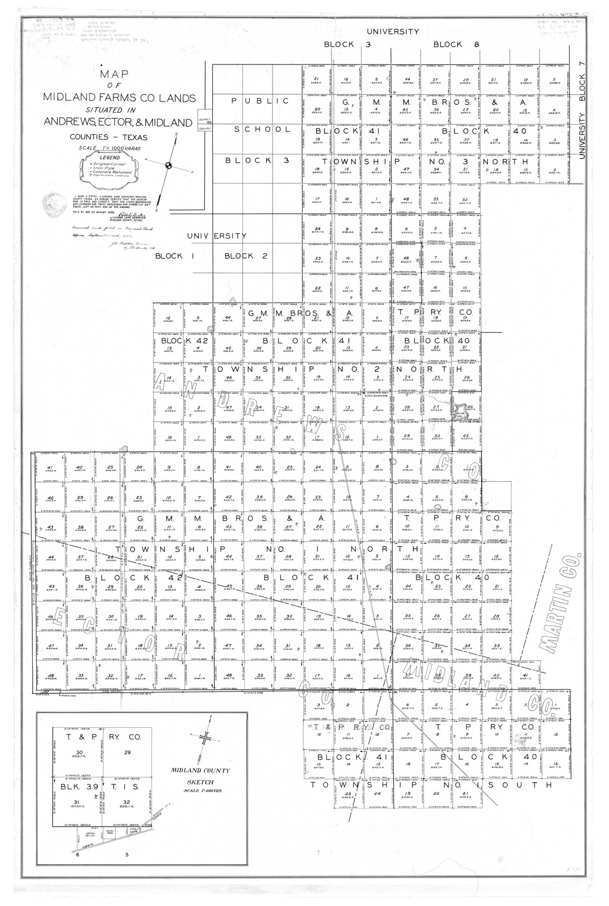
Map of Midland Farms Co. lands situated in Andrews, Ector, & Midland Counties
-
Map/Doc
8390
-
Collection
General Map Collection
-
Object Dates
1933/8/31 (Creation Date)
1933/9/14 (File Date)
-
People and Organizations
Robt. E. Estes (Surveyor/Engineer)
J.H. Walker (GLO Commissioner)
C.F. Blucher (GLO Clerk)
-
Counties
Andrews Ector Midland
-
Subjects
Surveying Rolled Sketch
-
Height x Width
58.1 x 39.1 inches
147.6 x 99.3 cm
-
Medium
linen, manuscript
-
Scale
1" = 1000 varas
-
Features
Baird Lake
Related maps
Andrews County Rolled Sketch 12B

Print $20.00
- Digital $50.00
Andrews County Rolled Sketch 12B
1933
Size 39.9 x 37.8 inches
Map/Doc 8392
Part of: General Map Collection
Falls County Working Sketch 1

Print $20.00
- Digital $50.00
Falls County Working Sketch 1
1922
Size 23.0 x 33.1 inches
Map/Doc 69176
Travis County Sketch File 35

Print $2.00
- Digital $50.00
Travis County Sketch File 35
Size 10.8 x 8.3 inches
Map/Doc 38354
Lamb County Boundary File 1b

Print $2.00
- Digital $50.00
Lamb County Boundary File 1b
Size 10.9 x 8.8 inches
Map/Doc 56044
Matagorda County Working Sketch 4

Print $20.00
- Digital $50.00
Matagorda County Working Sketch 4
1908
Size 33.1 x 32.0 inches
Map/Doc 70862
Bexar County Sketch File 47

Print $40.00
- Digital $50.00
Bexar County Sketch File 47
1896
Size 9.9 x 19.6 inches
Map/Doc 10925
Gregg County Rolled Sketch 14

Print $20.00
- Digital $50.00
Gregg County Rolled Sketch 14
1940
Size 42.4 x 14.1 inches
Map/Doc 6037
Real County Working Sketch 8

Print $20.00
- Digital $50.00
Real County Working Sketch 8
1928
Size 38.1 x 44.3 inches
Map/Doc 71900
Flight Mission No. BRA-7M, Frame 30, Jefferson County

Print $20.00
- Digital $50.00
Flight Mission No. BRA-7M, Frame 30, Jefferson County
1953
Size 18.6 x 22.3 inches
Map/Doc 85481
Reeves County

Print $40.00
- Digital $50.00
Reeves County
1945
Size 49.4 x 40.8 inches
Map/Doc 95624
Bandera County Sketch File 9

Print $2.00
- Digital $50.00
Bandera County Sketch File 9
Size 8.7 x 4.9 inches
Map/Doc 14009
Coast Chart No. 212 - From Latitude 26° 33' to the Rio Grande, Texas

Print $20.00
- Digital $50.00
Coast Chart No. 212 - From Latitude 26° 33' to the Rio Grande, Texas
1886
Size 30.5 x 24.1 inches
Map/Doc 73504
Montgomery County Rolled Sketch 13

Print $40.00
- Digital $50.00
Montgomery County Rolled Sketch 13
1932
Size 37.9 x 57.3 inches
Map/Doc 9526
You may also like
Houston County State Real Property Sketch 1

Print $20.00
- Digital $50.00
Houston County State Real Property Sketch 1
1997
Size 35.5 x 24.4 inches
Map/Doc 80129
Plat of Corpus Christi

Print $20.00
Plat of Corpus Christi
1850
Size 18.0 x 27.2 inches
Map/Doc 76269
Montague County Working Sketch 29

Print $20.00
- Digital $50.00
Montague County Working Sketch 29
1972
Size 27.8 x 22.1 inches
Map/Doc 71095
Brazos County Rolled Sketch 6

Print $20.00
- Digital $50.00
Brazos County Rolled Sketch 6
1979
Size 24.3 x 36.4 inches
Map/Doc 5190
Right of Way and Track Map Houston & Texas Central R.R. operated by the T. & N.O. R.R. Co., Austin Branch

Print $40.00
- Digital $50.00
Right of Way and Track Map Houston & Texas Central R.R. operated by the T. & N.O. R.R. Co., Austin Branch
1918
Size 25.8 x 58.2 inches
Map/Doc 64554
Presidio County Rolled Sketch 4

Print $2.00
- Digital $50.00
Presidio County Rolled Sketch 4
Size 10.1 x 6.3 inches
Map/Doc 75984

Harris County Boundary File 39 (17)

Print $4.00
- Digital $50.00
Harris County Boundary File 39 (17)
Size 10.0 x 8.1 inches
Map/Doc 54357

Parker County Working Sketch 21

Print $20.00
- Digital $50.00
Parker County Working Sketch 21
2006
Map/Doc 83655
Subdivision of the J. F. Carter Estate

Print $2.00
- Digital $50.00
Subdivision of the J. F. Carter Estate
Size 11.8 x 9.0 inches
Map/Doc 91279
