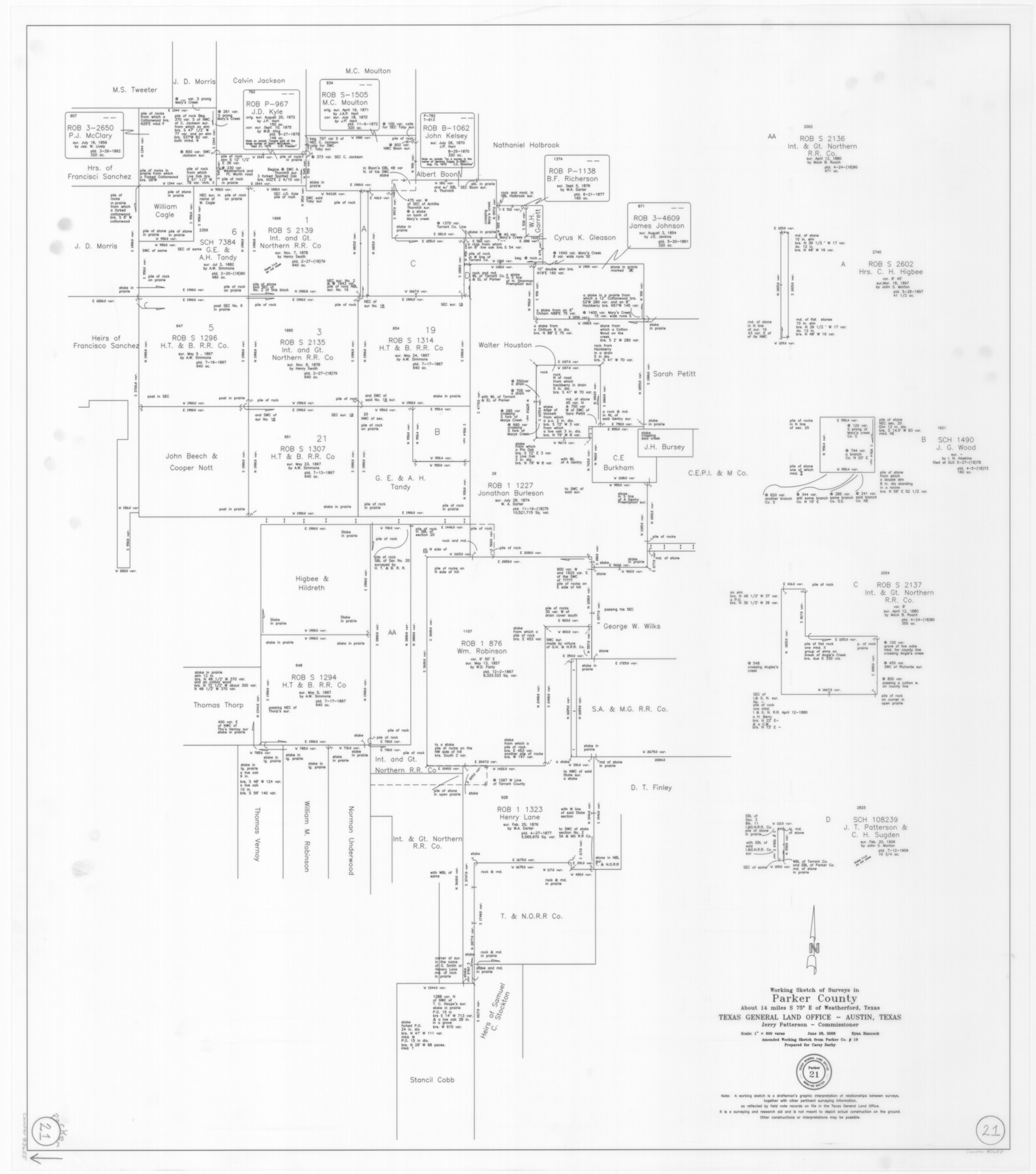
Parker County Working Sketch 21
-
Map/Doc
83655
-
Collection
General Map Collection
-
Object Dates
6/28/2006 (Creation Date)
-
People and Organizations
Jerry E. Patterson (GLO Commissioner)
Ryan Hancock (Draftsman)
-
Counties
Parker
-
Subjects
Surveying Working Sketch
-
Scale
1" = 600 varas
Part of: General Map Collection
Intracoastal Waterway, Houma, LA to Corpus Christi, TX

Print $20.00
- Digital $50.00
Intracoastal Waterway, Houma, LA to Corpus Christi, TX
Size 26.6 x 20.8 inches
Map/Doc 61907
Comal County Rolled Sketch 2

Print $20.00
- Digital $50.00
Comal County Rolled Sketch 2
1974
Size 21.8 x 13.3 inches
Map/Doc 5537
From Aransas Pass Eastward, Texas

Print $40.00
- Digital $50.00
From Aransas Pass Eastward, Texas
1866
Size 31.4 x 53.6 inches
Map/Doc 73426
Pecos County Rolled Sketch 129

Print $40.00
- Digital $50.00
Pecos County Rolled Sketch 129
1948
Size 42.9 x 52.4 inches
Map/Doc 9727
Andrews County Rolled Sketch 12

Print $40.00
- Digital $50.00
Andrews County Rolled Sketch 12
1933
Size 58.1 x 39.1 inches
Map/Doc 8390
Harris County Working Sketch 21

Print $20.00
- Digital $50.00
Harris County Working Sketch 21
Size 14.1 x 22.6 inches
Map/Doc 65913
Tyler County Sketch File 7

Print $4.00
- Digital $50.00
Tyler County Sketch File 7
1874
Size 13.4 x 7.7 inches
Map/Doc 38637
Hudspeth County Rolled Sketch 20

Print $20.00
- Digital $50.00
Hudspeth County Rolled Sketch 20
Size 39.5 x 44.3 inches
Map/Doc 76028
Nueces County Rolled Sketch 27

Print $40.00
- Digital $50.00
Nueces County Rolled Sketch 27
1946
Size 180.8 x 12.6 inches
Map/Doc 9596
Hutchinson County Boundary File 2

Print $2.00
- Digital $50.00
Hutchinson County Boundary File 2
Size 11.2 x 8.8 inches
Map/Doc 55302
Erath County Working Sketch 36

Print $20.00
- Digital $50.00
Erath County Working Sketch 36
1973
Size 33.5 x 30.4 inches
Map/Doc 69117
Matagorda County Aerial Photograph Index Sheet 5

Print $20.00
- Digital $50.00
Matagorda County Aerial Photograph Index Sheet 5
1953
Size 23.6 x 19.5 inches
Map/Doc 83726
You may also like
Wharton County Working Sketch 18

Print $20.00
- Digital $50.00
Wharton County Working Sketch 18
1948
Size 19.3 x 17.0 inches
Map/Doc 72482
[Map showing Gaines, Dawson, Yoakum, Terry and Lynn Counties]
![92007, [Map showing Gaines, Dawson, Yoakum, Terry and Lynn Counties], Twichell Survey Records](https://historictexasmaps.com/wmedia_w700/maps/92007-1.tif.jpg)
Print $20.00
- Digital $50.00
[Map showing Gaines, Dawson, Yoakum, Terry and Lynn Counties]
Size 24.2 x 20.7 inches
Map/Doc 92007
Brewster County Rolled Sketch 134

Print $20.00
- Digital $50.00
Brewster County Rolled Sketch 134
Size 19.0 x 24.9 inches
Map/Doc 5303
Coke County Sketch File 22

Print $20.00
- Digital $50.00
Coke County Sketch File 22
1923
Size 22.1 x 27.8 inches
Map/Doc 11111
Brazoria County

Print $40.00
- Digital $50.00
Brazoria County
1891
Size 47.1 x 54.2 inches
Map/Doc 4890
Filisola Empresario Colony. October 15, 1831

Print $20.00
Filisola Empresario Colony. October 15, 1831
2020
Size 15.3 x 21.7 inches
Map/Doc 95995
Brewster County Rolled Sketch 95

Print $20.00
- Digital $50.00
Brewster County Rolled Sketch 95
1947
Size 29.4 x 38.0 inches
Map/Doc 5252
Presidio County Sketch File 108

Print $6.00
- Digital $50.00
Presidio County Sketch File 108
Size 10.9 x 8.5 inches
Map/Doc 41455
[Sketch for Mineral Application 16700 - Pecos River Bed]
![2806, [Sketch for Mineral Application 16700 - Pecos River Bed], General Map Collection](https://historictexasmaps.com/wmedia_w700/maps/2806.tif.jpg)
Print $20.00
- Digital $50.00
[Sketch for Mineral Application 16700 - Pecos River Bed]
1927
Size 20.3 x 29.1 inches
Map/Doc 2806
Archer County Boundary File 1

Print $26.00
- Digital $50.00
Archer County Boundary File 1
Size 14.2 x 8.8 inches
Map/Doc 50082
Map of the Western Part of Bexar District

Print $40.00
- Digital $50.00
Map of the Western Part of Bexar District
1849
Size 63.5 x 21.6 inches
Map/Doc 87375
Working Sketch in Lipscomb County [showing East line of County along border with Oklahoma]
![92083, Working Sketch in Lipscomb County [showing East line of County along border with Oklahoma], Twichell Survey Records](https://historictexasmaps.com/wmedia_w700/maps/92083-1.tif.jpg)
Print $20.00
- Digital $50.00
Working Sketch in Lipscomb County [showing East line of County along border with Oklahoma]
1910
Size 4.9 x 25.9 inches
Map/Doc 92083