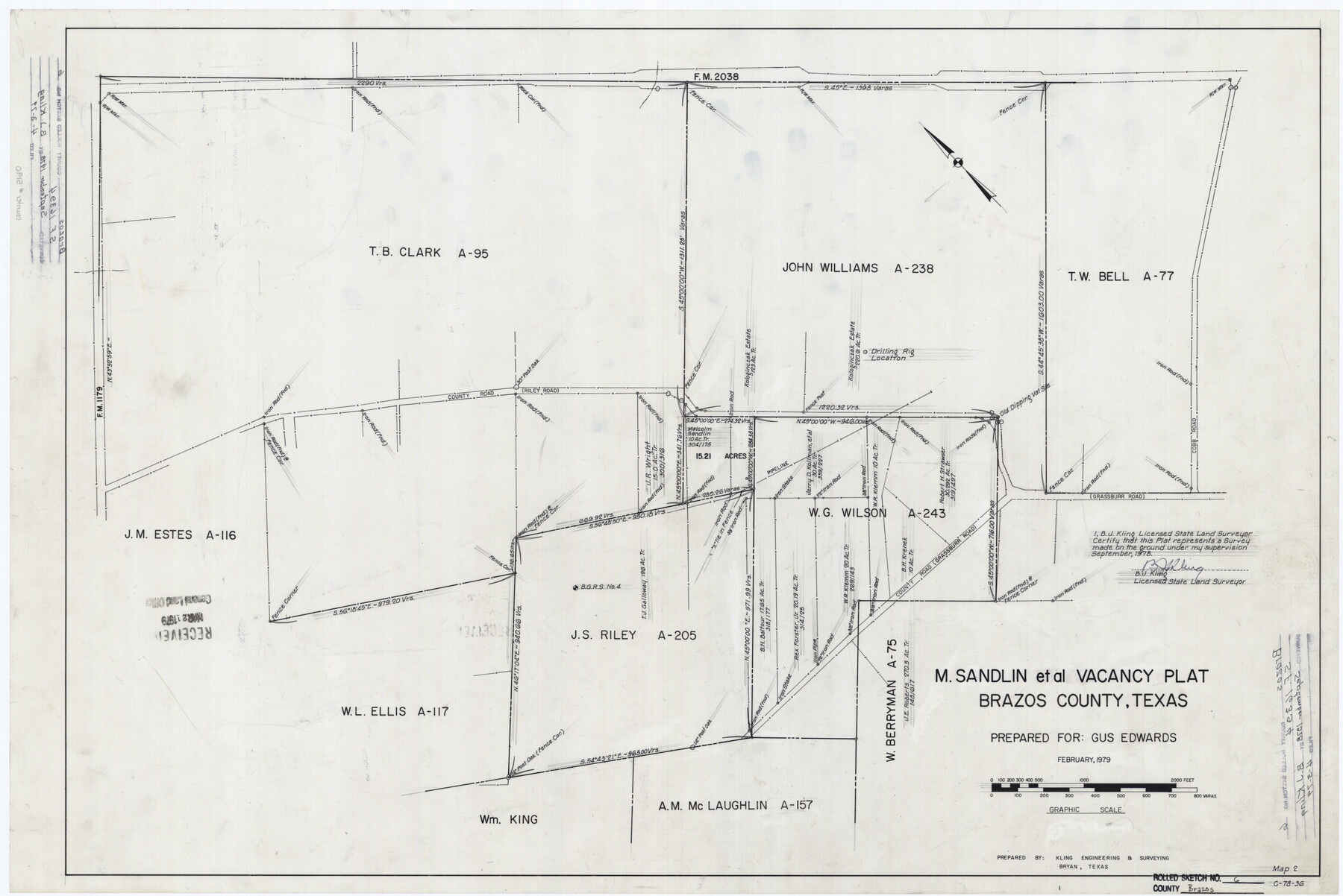
Brazos County Rolled Sketch 6
M. Sandlin et al vacancy plat, Brazos County, Texas
-
Map/Doc
5190
-
Collection
General Map Collection
-
Object Dates
1978 (Survey Date)
1979/4/3 (File Date)
1979 (Creation Date)
-
People and Organizations
B.J. Kling (Surveyor/Engineer)
-
Counties
Brazos
-
Subjects
Surveying Rolled Sketch
-
Height x Width
24.3 x 36.4 inches
61.7 x 92.5 cm
-
Medium
mylar, print
Part of: General Map Collection
Rusk County Sketch File 33

Print $10.00
Rusk County Sketch File 33
1949
Size 11.5 x 8.8 inches
Map/Doc 35568
Morris County Rolled Sketch 2A

Print $20.00
- Digital $50.00
Morris County Rolled Sketch 2A
Size 24.2 x 19.1 inches
Map/Doc 10243
Map of Espiritu Santo Bay in Calhoun County showing subdivision therof for mineral development

Print $20.00
- Digital $50.00
Map of Espiritu Santo Bay in Calhoun County showing subdivision therof for mineral development
1938
Size 38.6 x 42.9 inches
Map/Doc 2499
Map of Dallas County

Print $20.00
- Digital $50.00
Map of Dallas County
1861
Size 23.5 x 20.0 inches
Map/Doc 3467
Dickens County Sketch File 14a

Print $20.00
- Digital $50.00
Dickens County Sketch File 14a
Size 18.2 x 16.5 inches
Map/Doc 11321
Jack County Sketch File 18

Print $4.00
- Digital $50.00
Jack County Sketch File 18
1880
Size 10.4 x 8.2 inches
Map/Doc 27553
Montgomery County Boundary File 1

Print $4.00
- Digital $50.00
Montgomery County Boundary File 1
Size 5.8 x 5.5 inches
Map/Doc 57446
[Map of Nacogdoches County]
![10784, [Map of Nacogdoches County], General Map Collection](https://historictexasmaps.com/wmedia_w700/maps/10784-1.tif.jpg)
Print $40.00
- Digital $50.00
[Map of Nacogdoches County]
1840
Size 79.3 x 69.8 inches
Map/Doc 10784
Calhoun County Rolled Sketch 20

Print $20.00
- Digital $50.00
Calhoun County Rolled Sketch 20
1959
Size 36.9 x 20.7 inches
Map/Doc 5372
Map of Grayson County

Print $20.00
- Digital $50.00
Map of Grayson County
1871
Size 19.5 x 17.8 inches
Map/Doc 1088
Moore County Working Sketch 8

Print $20.00
- Digital $50.00
Moore County Working Sketch 8
1948
Size 23.2 x 31.8 inches
Map/Doc 71190
Baylor County Sketch File 1

Print $6.00
- Digital $50.00
Baylor County Sketch File 1
Size 17.5 x 11.4 inches
Map/Doc 14117
You may also like
Flight Mission No. BRE-2P, Frame 125, Nueces County

Print $20.00
- Digital $50.00
Flight Mission No. BRE-2P, Frame 125, Nueces County
1956
Size 18.5 x 22.6 inches
Map/Doc 86801
English Field Notes of the Spanish Archives - Book D

English Field Notes of the Spanish Archives - Book D
1835
Map/Doc 96542
Atascosa County Sketch File 29

Print $40.00
- Digital $50.00
Atascosa County Sketch File 29
Size 23.7 x 12.9 inches
Map/Doc 10863
Sterling County Sketch File 24

Print $6.00
- Digital $50.00
Sterling County Sketch File 24
1955
Size 11.1 x 8.5 inches
Map/Doc 37189
Topographical Map of the Rio Grande, Sheet No. 20

Print $20.00
- Digital $50.00
Topographical Map of the Rio Grande, Sheet No. 20
1912
Map/Doc 89544
Cameron County Rolled Sketch 25

Print $20.00
- Digital $50.00
Cameron County Rolled Sketch 25
1977
Size 17.5 x 27.5 inches
Map/Doc 5790
[T. C. & S. F. Block K11, Capitol Leagues 367, 373, 374, and Blocks D and B]
![90536, [T. C. & S. F. Block K11, Capitol Leagues 367, 373, 374, and Blocks D and B], Twichell Survey Records](https://historictexasmaps.com/wmedia_w700/maps/90536-1.tif.jpg)
Print $3.00
- Digital $50.00
[T. C. & S. F. Block K11, Capitol Leagues 367, 373, 374, and Blocks D and B]
1903
Size 9.5 x 13.7 inches
Map/Doc 90536
San Augustine County Sketch File 10

Print $4.00
San Augustine County Sketch File 10
Size 12.8 x 8.1 inches
Map/Doc 35652
Medina County Working Sketch 15

Print $20.00
- Digital $50.00
Medina County Working Sketch 15
1974
Size 26.2 x 18.7 inches
Map/Doc 70930
Live Oak County Boundary File 60a

Print $18.00
- Digital $50.00
Live Oak County Boundary File 60a
Size 12.7 x 8.4 inches
Map/Doc 56407
Borden County Boundary File 4

Print $2.00
- Digital $50.00
Borden County Boundary File 4
Size 13.3 x 8.3 inches
Map/Doc 50636
