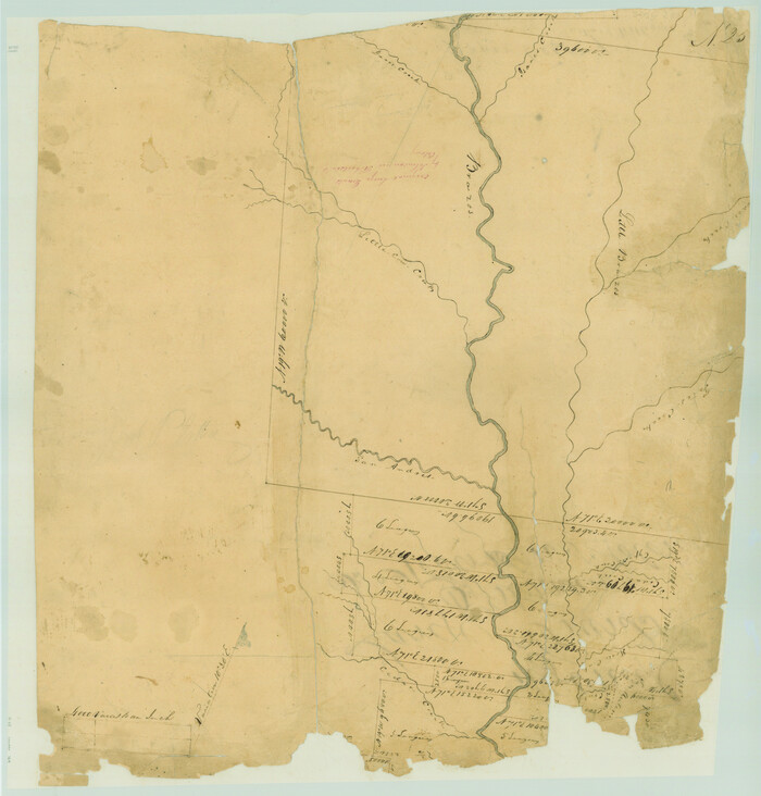
Brazos County Sketch File 1

Print $4.00
- Digital $50.00
Brazos County Sketch File 1
1858
Size: 10.4 x 7.6 inches
15550
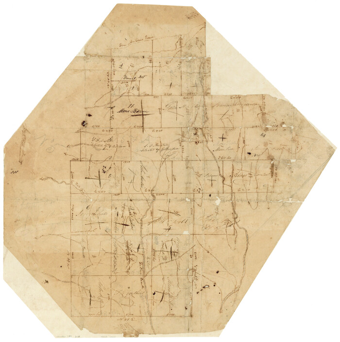
Brazos County Sketch File 2

Print $4.00
- Digital $50.00
Brazos County Sketch File 2
1858
Size: 7.9 x 9.4 inches
15552
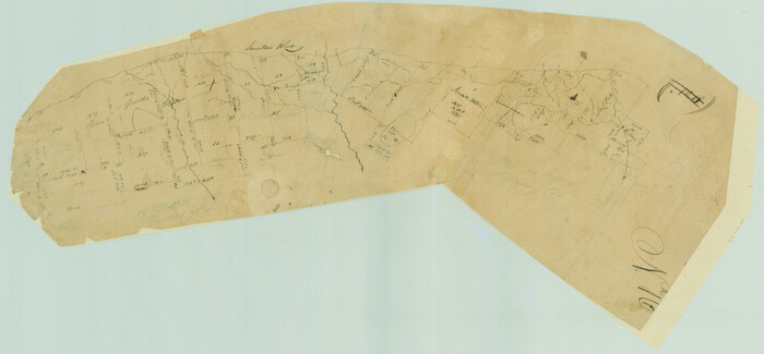
Brazos County Sketch File 3

Print $6.00
- Digital $50.00
Brazos County Sketch File 3
1861
Size: 11.1 x 8.0 inches
15554
Brazos County Sketch File 4

Print $4.00
- Digital $50.00
Brazos County Sketch File 4
1928
Size: 11.5 x 7.3 inches
15557
Brazos County Sketch File 5

Print $34.00
- Digital $50.00
Brazos County Sketch File 5
1935
Size: 8.2 x 7.1 inches
15559
[Surveys in Austin's Colony along the Brazos River]
Print $20.00
- Digital $50.00
[Surveys in Austin's Colony along the Brazos River]
1833
Size: 25.0 x 23.9 inches
164
[Surveys in Austin's Colony along Saline Creek]
Print $20.00
- Digital $50.00
[Surveys in Austin's Colony along Saline Creek]
Size: 20.8 x 20.7 inches
180
[Surveys in Austin's Colony along the San Antonio Road and the Navasota River]
Print $20.00
- Digital $50.00
[Surveys in Austin's Colony along the San Antonio Road and the Navasota River]
1833
Size: 16.1 x 34.7 inches
202
Official Map of the City of Bryan from Actual Survey [East half]
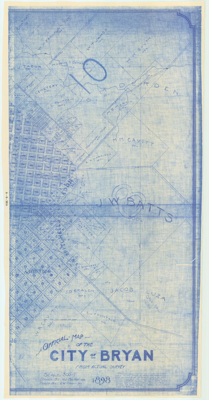
Print $40.00
- Digital $50.00
Official Map of the City of Bryan from Actual Survey [East half]
1898
Size: 52.3 x 27.4 inches
3203
Map of Bryan, Brazos County, Texas

Print $20.00
- Digital $50.00
Map of Bryan, Brazos County, Texas
1915
Size: 18.5 x 24.6 inches
3210

Map of Brazos County

Print $20.00
- Digital $50.00
Map of Brazos County
1867
Size: 23.4 x 16.8 inches
3327
Map of Navisota County

Print $20.00
- Digital $50.00
Map of Navisota County
Size: 27.5 x 19.6 inches
3328
Brazos County Rolled Sketch 6

Print $20.00
- Digital $50.00
Brazos County Rolled Sketch 6
1979
Size: 24.3 x 36.4 inches
5190
Map of Brazos County, Texas

Print $20.00
- Digital $50.00
Map of Brazos County, Texas
1879
Size: 21.6 x 15.3 inches
597
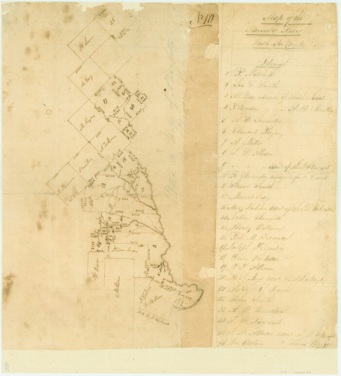
Map of the Navosoto [sp.] River, Washington County
Print $20.00
- Digital $50.00
Map of the Navosoto [sp.] River, Washington County
1842
Size: 15.7 x 14.2 inches
64
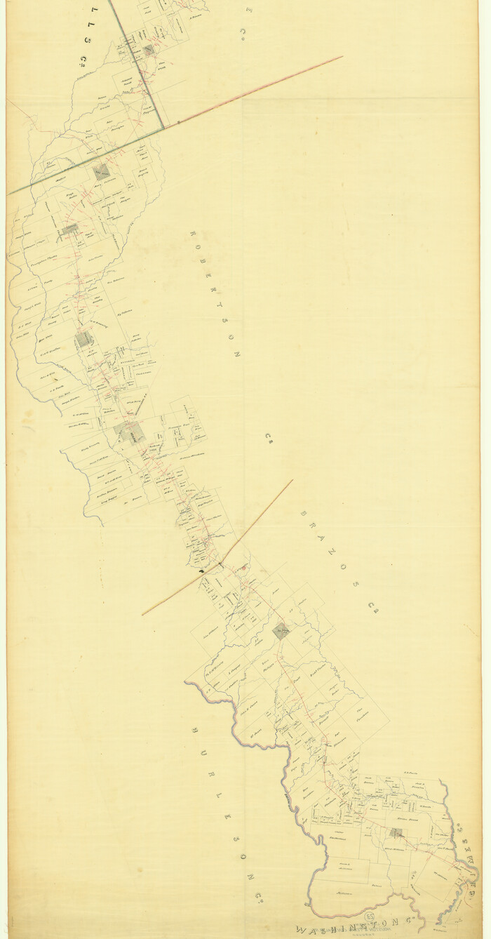
[Map of the Line of the H. & Texas Cen. Railway from the Navasota River, 72 1/2 Miles from Houston, to Corsicana in Navarro Co., 211 mls from Houston]
Print $40.00
- Digital $50.00
[Map of the Line of the H. & Texas Cen. Railway from the Navasota River, 72 1/2 Miles from Houston, to Corsicana in Navarro Co., 211 mls from Houston]
Size: 75.6 x 39.6 inches
64087
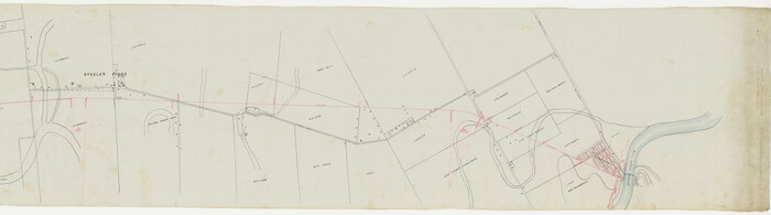
Map of the Hearne and Brazos Valley Railroad from Mumford to Moseley's Ferry

Print $40.00
- Digital $50.00
Map of the Hearne and Brazos Valley Railroad from Mumford to Moseley's Ferry
1892
Size: 20.0 x 56.8 inches
64400
[Map of the Hearne and Brazos Valley Railroad from Mumford to Moseley's Ferry]
Print $40.00
- Digital $50.00
[Map of the Hearne and Brazos Valley Railroad from Mumford to Moseley's Ferry]
1892
Size: 20.0 x 71.5 inches
64401
Brazos River, Washington Sheet

Print $6.00
- Digital $50.00
Brazos River, Washington Sheet
1936
Size: 30.4 x 24.7 inches
65277
Brazos River, Millican Sheet

Print $6.00
- Digital $50.00
Brazos River, Millican Sheet
1936
Size: 30.1 x 31.6 inches
65278
Brazos River, Sandpit Special Sheet

Print $6.00
- Digital $50.00
Brazos River, Sandpit Special Sheet
1936
Size: 33.8 x 24.7 inches
65279
Brazos River, Jones Bridge Special Map Sheet

Print $4.00
- Digital $50.00
Brazos River, Jones Bridge Special Map Sheet
1936
Size: 29.8 x 28.2 inches
65280
Brazos River, Widths of Floodways/Brazos and Navasota Rivers

Print $20.00
- Digital $50.00
Brazos River, Widths of Floodways/Brazos and Navasota Rivers
1921
Size: 38.1 x 24.5 inches
65292
Brazos River, Brazos River Sheet 1

Print $4.00
- Digital $50.00
Brazos River, Brazos River Sheet 1
1926
Size: 21.5 x 25.4 inches
65293
Brazos River, Brazos River Sheet 2

Print $6.00
- Digital $50.00
Brazos River, Brazos River Sheet 2
1926
Size: 25.0 x 31.4 inches
65294
Brazos County Working Sketch 1

Print $20.00
- Digital $50.00
Brazos County Working Sketch 1
1911
Size: 26.5 x 16.3 inches
67476
Brazos County Working Sketch 2

Print $20.00
- Digital $50.00
Brazos County Working Sketch 2
1950
Size: 31.9 x 36.0 inches
67477
Brazos County Working Sketch 3

Print $20.00
- Digital $50.00
Brazos County Working Sketch 3
1976
Size: 22.0 x 18.4 inches
67478
Brazos County Sketch File 1
Print $4.00
- Digital $50.00
Brazos County Sketch File 1
1858
-
Size
10.4 x 7.6 inches
-
Map/Doc
15550
-
Creation Date
1858
Brazos County Sketch File 2
Print $4.00
- Digital $50.00
Brazos County Sketch File 2
1858
-
Size
7.9 x 9.4 inches
-
Map/Doc
15552
-
Creation Date
1858
Brazos County Sketch File 3
Print $6.00
- Digital $50.00
Brazos County Sketch File 3
1861
-
Size
11.1 x 8.0 inches
-
Map/Doc
15554
-
Creation Date
1861
Brazos County Sketch File 4
Print $4.00
- Digital $50.00
Brazos County Sketch File 4
1928
-
Size
11.5 x 7.3 inches
-
Map/Doc
15557
-
Creation Date
1928
Brazos County Sketch File 5
Print $34.00
- Digital $50.00
Brazos County Sketch File 5
1935
-
Size
8.2 x 7.1 inches
-
Map/Doc
15559
-
Creation Date
1935
[Surveys in Austin's Colony along the Brazos River]
Print $20.00
- Digital $50.00
[Surveys in Austin's Colony along the Brazos River]
1833
-
Size
25.0 x 23.9 inches
-
Map/Doc
164
-
Creation Date
1833
[Surveys in Austin's Colony along Saline Creek]
Print $20.00
- Digital $50.00
[Surveys in Austin's Colony along Saline Creek]
-
Size
20.8 x 20.7 inches
-
Map/Doc
180
[Surveys in Austin's Colony along the San Antonio Road and the Navasota River]
Print $20.00
- Digital $50.00
[Surveys in Austin's Colony along the San Antonio Road and the Navasota River]
1833
-
Size
16.1 x 34.7 inches
-
Map/Doc
202
-
Creation Date
1833
Official Map of the City of Bryan from Actual Survey [East half]
Print $40.00
- Digital $50.00
Official Map of the City of Bryan from Actual Survey [East half]
1898
-
Size
52.3 x 27.4 inches
-
Map/Doc
3203
-
Creation Date
1898
Map of Bryan, Brazos County, Texas
Print $20.00
- Digital $50.00
Map of Bryan, Brazos County, Texas
1915
-
Size
18.5 x 24.6 inches
-
Map/Doc
3210
-
Creation Date
1915
Brazos County

Print $20.00
- Digital $50.00
Brazos County
1871
-
Size
22.3 x 16.3 inches
-
Map/Doc
3325
-
Creation Date
1871
Map of Brazos County
Print $20.00
- Digital $50.00
Map of Brazos County
1867
-
Size
23.4 x 16.8 inches
-
Map/Doc
3327
-
Creation Date
1867
Map of Navisota County
Print $20.00
- Digital $50.00
Map of Navisota County
-
Size
27.5 x 19.6 inches
-
Map/Doc
3328
Brazos County Rolled Sketch 6
Print $20.00
- Digital $50.00
Brazos County Rolled Sketch 6
1979
-
Size
24.3 x 36.4 inches
-
Map/Doc
5190
-
Creation Date
1979
Map of Brazos County, Texas
Print $20.00
- Digital $50.00
Map of Brazos County, Texas
1879
-
Size
21.6 x 15.3 inches
-
Map/Doc
597
-
Creation Date
1879
Map of the Navosoto [sp.] River, Washington County
Print $20.00
- Digital $50.00
Map of the Navosoto [sp.] River, Washington County
1842
-
Size
15.7 x 14.2 inches
-
Map/Doc
64
-
Creation Date
1842
[Map of the Line of the H. & Texas Cen. Railway from the Navasota River, 72 1/2 Miles from Houston, to Corsicana in Navarro Co., 211 mls from Houston]
Print $40.00
- Digital $50.00
[Map of the Line of the H. & Texas Cen. Railway from the Navasota River, 72 1/2 Miles from Houston, to Corsicana in Navarro Co., 211 mls from Houston]
-
Size
75.6 x 39.6 inches
-
Map/Doc
64087
Map of the Hearne and Brazos Valley Railroad from Mumford to Moseley's Ferry
Print $40.00
- Digital $50.00
Map of the Hearne and Brazos Valley Railroad from Mumford to Moseley's Ferry
1892
-
Size
20.0 x 56.8 inches
-
Map/Doc
64400
-
Creation Date
1892
[Map of the Hearne and Brazos Valley Railroad from Mumford to Moseley's Ferry]
Print $40.00
- Digital $50.00
[Map of the Hearne and Brazos Valley Railroad from Mumford to Moseley's Ferry]
1892
-
Size
20.0 x 71.5 inches
-
Map/Doc
64401
-
Creation Date
1892
Brazos River, Washington Sheet
Print $6.00
- Digital $50.00
Brazos River, Washington Sheet
1936
-
Size
30.4 x 24.7 inches
-
Map/Doc
65277
-
Creation Date
1936
Brazos River, Millican Sheet
Print $6.00
- Digital $50.00
Brazos River, Millican Sheet
1936
-
Size
30.1 x 31.6 inches
-
Map/Doc
65278
-
Creation Date
1936
Brazos River, Sandpit Special Sheet
Print $6.00
- Digital $50.00
Brazos River, Sandpit Special Sheet
1936
-
Size
33.8 x 24.7 inches
-
Map/Doc
65279
-
Creation Date
1936
Brazos River, Jones Bridge Special Map Sheet
Print $4.00
- Digital $50.00
Brazos River, Jones Bridge Special Map Sheet
1936
-
Size
29.8 x 28.2 inches
-
Map/Doc
65280
-
Creation Date
1936
Brazos River, Widths of Floodways/Brazos and Navasota Rivers
Print $20.00
- Digital $50.00
Brazos River, Widths of Floodways/Brazos and Navasota Rivers
1921
-
Size
38.1 x 24.5 inches
-
Map/Doc
65292
-
Creation Date
1921
Brazos River, Brazos River Sheet 1
Print $4.00
- Digital $50.00
Brazos River, Brazos River Sheet 1
1926
-
Size
21.5 x 25.4 inches
-
Map/Doc
65293
-
Creation Date
1926
Brazos River, Brazos River Sheet 2
Print $6.00
- Digital $50.00
Brazos River, Brazos River Sheet 2
1926
-
Size
25.0 x 31.4 inches
-
Map/Doc
65294
-
Creation Date
1926
Brazos County Working Sketch 1
Print $20.00
- Digital $50.00
Brazos County Working Sketch 1
1911
-
Size
26.5 x 16.3 inches
-
Map/Doc
67476
-
Creation Date
1911
Brazos County Working Sketch 2
Print $20.00
- Digital $50.00
Brazos County Working Sketch 2
1950
-
Size
31.9 x 36.0 inches
-
Map/Doc
67477
-
Creation Date
1950
Brazos County Working Sketch 3
Print $20.00
- Digital $50.00
Brazos County Working Sketch 3
1976
-
Size
22.0 x 18.4 inches
-
Map/Doc
67478
-
Creation Date
1976