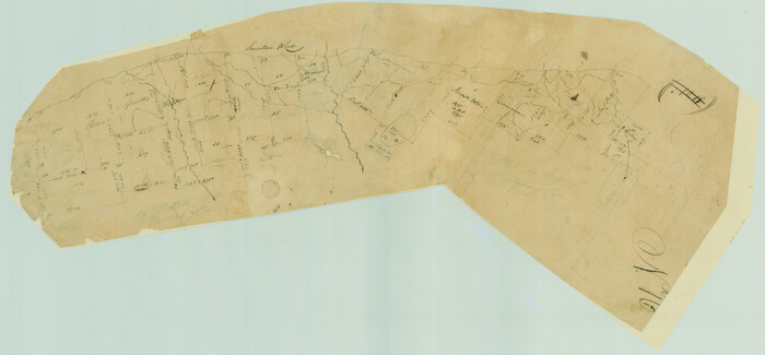
[Surveys in Austin's Colony along the San Antonio Road and the Navasota River]
Print $20.00
- Digital $50.00
[Surveys in Austin's Colony along the San Antonio Road and the Navasota River]
1833
Size: 16.1 x 34.7 inches
202
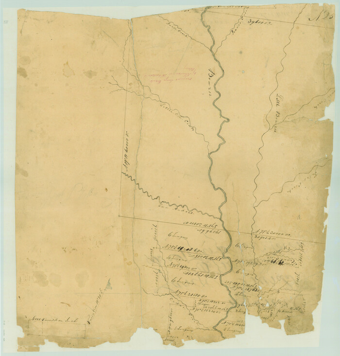
[Surveys in Austin's Colony along the Brazos River]
Print $20.00
- Digital $50.00
[Surveys in Austin's Colony along the Brazos River]
1833
Size: 25.0 x 23.9 inches
164
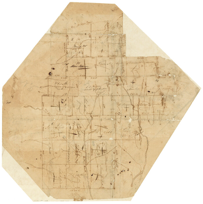
[Surveys in Austin's Colony along Saline Creek]
Print $20.00
- Digital $50.00
[Surveys in Austin's Colony along Saline Creek]
Size: 20.8 x 20.7 inches
180
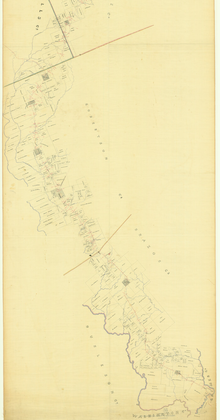
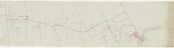
[Map of the Line of the H. & Texas Cen. Railway from the Navasota River, 72 1/2 Miles from Houston, to Corsicana in Navarro Co., 211 mls from Houston]
Print $40.00
- Digital $50.00
[Map of the Line of the H. & Texas Cen. Railway from the Navasota River, 72 1/2 Miles from Houston, to Corsicana in Navarro Co., 211 mls from Houston]
Size: 75.6 x 39.6 inches
64087
[Map of the Hearne and Brazos Valley Railroad from Mumford to Moseley's Ferry]
Print $40.00
- Digital $50.00
[Map of the Hearne and Brazos Valley Railroad from Mumford to Moseley's Ferry]
1892
Size: 20.0 x 71.5 inches
64401
The Republic County of Brazos. December 29, 1845

Print $20.00
The Republic County of Brazos. December 29, 1845
2020
Size: 20.6 x 21.7 inches
96117
The Republic County of Brazos. Created, January 30, 1841

Print $20.00
The Republic County of Brazos. Created, January 30, 1841
2020
Size: 20.6 x 21.7 inches
96116
Official Map of the City of Bryan from Actual Survey [West Part]
Print $40.00
- Digital $50.00
Official Map of the City of Bryan from Actual Survey [West Part]
1898
Size: 52.5 x 27.4 inches
76864
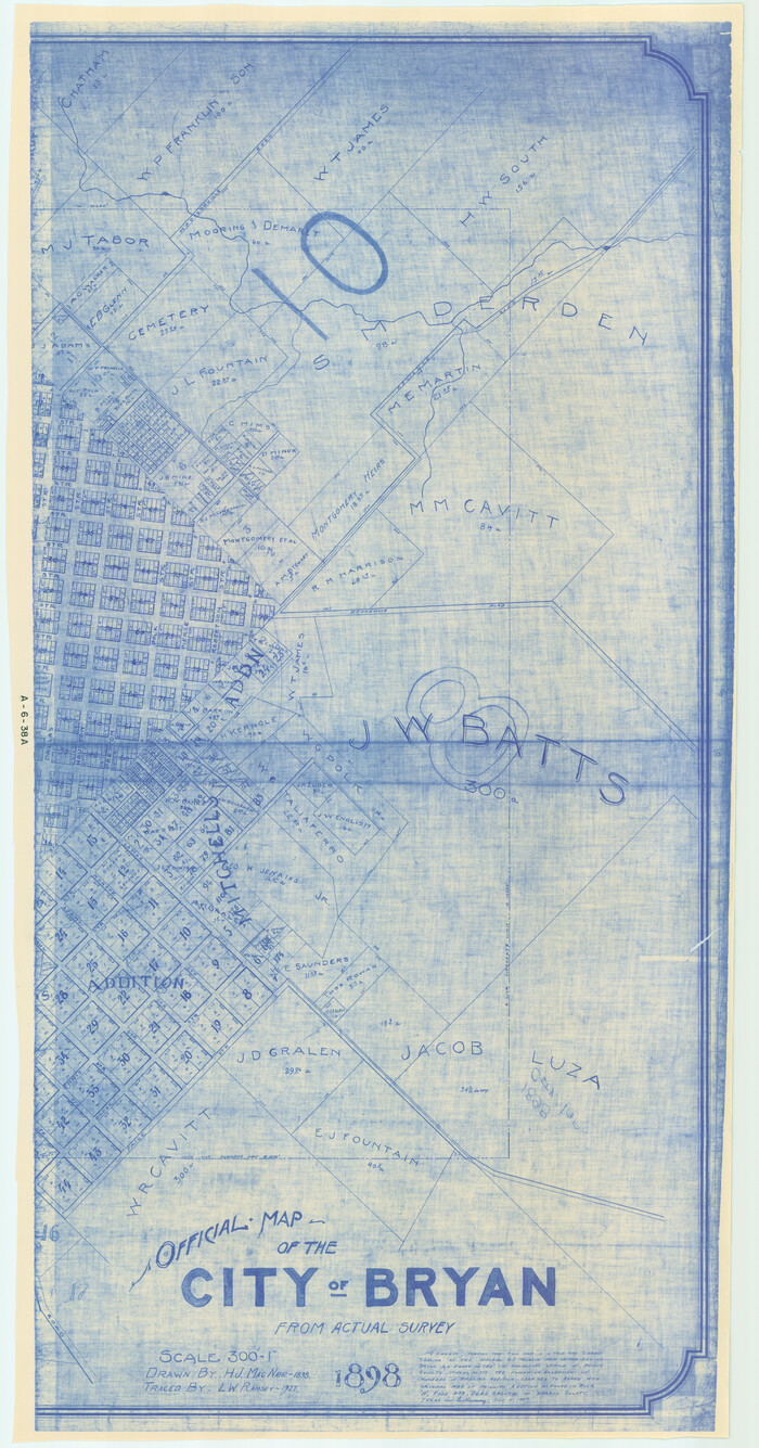
Official Map of the City of Bryan from Actual Survey [East half]
Print $40.00
- Digital $50.00
Official Map of the City of Bryan from Actual Survey [East half]
1898
Size: 52.3 x 27.4 inches
3203
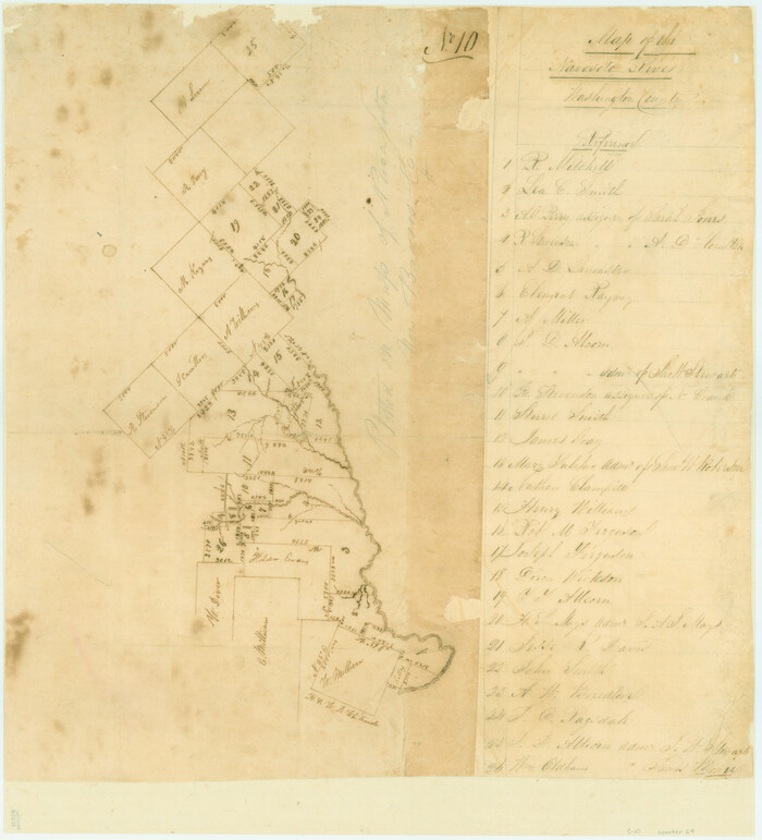
Map of the Navosoto [sp.] River, Washington County
Print $20.00
- Digital $50.00
Map of the Navosoto [sp.] River, Washington County
1842
Size: 15.7 x 14.2 inches
64
Map of the Hearne and Brazos Valley Railroad from Mumford to Moseley's Ferry

Print $40.00
- Digital $50.00
Map of the Hearne and Brazos Valley Railroad from Mumford to Moseley's Ferry
1892
Size: 20.0 x 56.8 inches
64400
Map of Navisota County

Print $20.00
- Digital $50.00
Map of Navisota County
Size: 27.5 x 19.6 inches
3328
Map of Bryan, Brazos County, Texas

Print $20.00
- Digital $50.00
Map of Bryan, Brazos County, Texas
1915
Size: 18.5 x 24.6 inches
3210
Map of Brazos County, Texas

Print $20.00
- Digital $50.00
Map of Brazos County, Texas
1879
Size: 21.6 x 15.3 inches
597
Map of Brazos County, Texas

Print $40.00
- Digital $50.00
Map of Brazos County, Texas
1926
Size: 89.6 x 55.1 inches
93648
Map of Brazos County

Print $20.00
- Digital $50.00
Map of Brazos County
1867
Size: 23.4 x 16.8 inches
3327
General Highway Map, Brazos County, Texas

Print $20.00
General Highway Map, Brazos County, Texas
1940
Size: 25.2 x 18.5 inches
79026
General Highway Map, Brazos County, Texas

Print $20.00
General Highway Map, Brazos County, Texas
1961
Size: 24.9 x 18.3 inches
79384
English Field Notes of the Spanish Archives - Books BTB, GA, BT, and X

English Field Notes of the Spanish Archives - Books BTB, GA, BT, and X
1835
96554
English Field Notes of the Spanish Archives - Book D

English Field Notes of the Spanish Archives - Book D
1835
96542
English Field Notes of the Spanish Archives - Book 7

English Field Notes of the Spanish Archives - Book 7
1835
96533
English Field Notes of the Spanish Archives - Book 2

English Field Notes of the Spanish Archives - Book 2
1835
96528
English Field Notes of the Spanish Archives - Book 10

English Field Notes of the Spanish Archives - Book 10
1835
96536
English Field Notes of the Spanish Archives - Book 1

English Field Notes of the Spanish Archives - Book 1
1833
96527
Brazos River, Widths of Floodways/Brazos and Navasota Rivers

Print $20.00
- Digital $50.00
Brazos River, Widths of Floodways/Brazos and Navasota Rivers
1921
Size: 38.1 x 24.5 inches
65292
Brazos River, Washington Sheet

Print $6.00
- Digital $50.00
Brazos River, Washington Sheet
1936
Size: 30.4 x 24.7 inches
65277
Brazos River, Sandpit Special Sheet

Print $6.00
- Digital $50.00
Brazos River, Sandpit Special Sheet
1936
Size: 33.8 x 24.7 inches
65279
Brazos River, Millican Sheet

Print $6.00
- Digital $50.00
Brazos River, Millican Sheet
1936
Size: 30.1 x 31.6 inches
65278
Brazos River, Jones Bridge Special Map Sheet

Print $4.00
- Digital $50.00
Brazos River, Jones Bridge Special Map Sheet
1936
Size: 29.8 x 28.2 inches
65280
[Surveys in Austin's Colony along the San Antonio Road and the Navasota River]
Print $20.00
- Digital $50.00
[Surveys in Austin's Colony along the San Antonio Road and the Navasota River]
1833
-
Size
16.1 x 34.7 inches
-
Map/Doc
202
-
Creation Date
1833
[Surveys in Austin's Colony along the Brazos River]
Print $20.00
- Digital $50.00
[Surveys in Austin's Colony along the Brazos River]
1833
-
Size
25.0 x 23.9 inches
-
Map/Doc
164
-
Creation Date
1833
[Surveys in Austin's Colony along Saline Creek]
Print $20.00
- Digital $50.00
[Surveys in Austin's Colony along Saline Creek]
-
Size
20.8 x 20.7 inches
-
Map/Doc
180
[Map of the Line of the H. & Texas Cen. Railway from the Navasota River, 72 1/2 Miles from Houston, to Corsicana in Navarro Co., 211 mls from Houston]
Print $40.00
- Digital $50.00
[Map of the Line of the H. & Texas Cen. Railway from the Navasota River, 72 1/2 Miles from Houston, to Corsicana in Navarro Co., 211 mls from Houston]
-
Size
75.6 x 39.6 inches
-
Map/Doc
64087
[Map of the Hearne and Brazos Valley Railroad from Mumford to Moseley's Ferry]
Print $40.00
- Digital $50.00
[Map of the Hearne and Brazos Valley Railroad from Mumford to Moseley's Ferry]
1892
-
Size
20.0 x 71.5 inches
-
Map/Doc
64401
-
Creation Date
1892
The Republic County of Brazos. December 29, 1845
Print $20.00
The Republic County of Brazos. December 29, 1845
2020
-
Size
20.6 x 21.7 inches
-
Map/Doc
96117
-
Creation Date
2020
The Republic County of Brazos. Created, January 30, 1841
Print $20.00
The Republic County of Brazos. Created, January 30, 1841
2020
-
Size
20.6 x 21.7 inches
-
Map/Doc
96116
-
Creation Date
2020
Official Map of the City of Bryan from Actual Survey [West Part]
Print $40.00
- Digital $50.00
Official Map of the City of Bryan from Actual Survey [West Part]
1898
-
Size
52.5 x 27.4 inches
-
Map/Doc
76864
-
Creation Date
1898
Official Map of the City of Bryan from Actual Survey [East half]
Print $40.00
- Digital $50.00
Official Map of the City of Bryan from Actual Survey [East half]
1898
-
Size
52.3 x 27.4 inches
-
Map/Doc
3203
-
Creation Date
1898
Navasota and Grimes County, Texas

Navasota and Grimes County, Texas
-
Size
25.8 x 28.5 inches
-
Map/Doc
96865
Map of the Navosoto [sp.] River, Washington County
Print $20.00
- Digital $50.00
Map of the Navosoto [sp.] River, Washington County
1842
-
Size
15.7 x 14.2 inches
-
Map/Doc
64
-
Creation Date
1842
Map of the Hearne and Brazos Valley Railroad from Mumford to Moseley's Ferry
Print $40.00
- Digital $50.00
Map of the Hearne and Brazos Valley Railroad from Mumford to Moseley's Ferry
1892
-
Size
20.0 x 56.8 inches
-
Map/Doc
64400
-
Creation Date
1892
Map of Navisota County
Print $20.00
- Digital $50.00
Map of Navisota County
-
Size
27.5 x 19.6 inches
-
Map/Doc
3328
Map of Bryan, Brazos County, Texas
Print $20.00
- Digital $50.00
Map of Bryan, Brazos County, Texas
1915
-
Size
18.5 x 24.6 inches
-
Map/Doc
3210
-
Creation Date
1915
Map of Brazos County, Texas
Print $20.00
- Digital $50.00
Map of Brazos County, Texas
1879
-
Size
21.6 x 15.3 inches
-
Map/Doc
597
-
Creation Date
1879
Map of Brazos County, Texas
Print $40.00
- Digital $50.00
Map of Brazos County, Texas
1926
-
Size
89.6 x 55.1 inches
-
Map/Doc
93648
-
Creation Date
1926
Map of Brazos County
Print $20.00
- Digital $50.00
Map of Brazos County
1867
-
Size
23.4 x 16.8 inches
-
Map/Doc
3327
-
Creation Date
1867
General Highway Map, Brazos County, Texas
Print $20.00
General Highway Map, Brazos County, Texas
1940
-
Size
25.2 x 18.5 inches
-
Map/Doc
79026
-
Creation Date
1940
General Highway Map, Brazos County, Texas
Print $20.00
General Highway Map, Brazos County, Texas
1961
-
Size
24.9 x 18.3 inches
-
Map/Doc
79384
-
Creation Date
1961
English Field Notes of the Spanish Archives - Books BTB, GA, BT, and X
English Field Notes of the Spanish Archives - Books BTB, GA, BT, and X
1835
-
Map/Doc
96554
-
Creation Date
1835
English Field Notes of the Spanish Archives - Book D
English Field Notes of the Spanish Archives - Book D
1835
-
Map/Doc
96542
-
Creation Date
1835
English Field Notes of the Spanish Archives - Book 7
English Field Notes of the Spanish Archives - Book 7
1835
-
Map/Doc
96533
-
Creation Date
1835
English Field Notes of the Spanish Archives - Book 2
English Field Notes of the Spanish Archives - Book 2
1835
-
Map/Doc
96528
-
Creation Date
1835
English Field Notes of the Spanish Archives - Book 10
English Field Notes of the Spanish Archives - Book 10
1835
-
Map/Doc
96536
-
Creation Date
1835
English Field Notes of the Spanish Archives - Book 1
English Field Notes of the Spanish Archives - Book 1
1833
-
Map/Doc
96527
-
Creation Date
1833
Brazos River, Widths of Floodways/Brazos and Navasota Rivers
Print $20.00
- Digital $50.00
Brazos River, Widths of Floodways/Brazos and Navasota Rivers
1921
-
Size
38.1 x 24.5 inches
-
Map/Doc
65292
-
Creation Date
1921
Brazos River, Washington Sheet
Print $6.00
- Digital $50.00
Brazos River, Washington Sheet
1936
-
Size
30.4 x 24.7 inches
-
Map/Doc
65277
-
Creation Date
1936
Brazos River, Sandpit Special Sheet
Print $6.00
- Digital $50.00
Brazos River, Sandpit Special Sheet
1936
-
Size
33.8 x 24.7 inches
-
Map/Doc
65279
-
Creation Date
1936
Brazos River, Millican Sheet
Print $6.00
- Digital $50.00
Brazos River, Millican Sheet
1936
-
Size
30.1 x 31.6 inches
-
Map/Doc
65278
-
Creation Date
1936
Brazos River, Jones Bridge Special Map Sheet
Print $4.00
- Digital $50.00
Brazos River, Jones Bridge Special Map Sheet
1936
-
Size
29.8 x 28.2 inches
-
Map/Doc
65280
-
Creation Date
1936