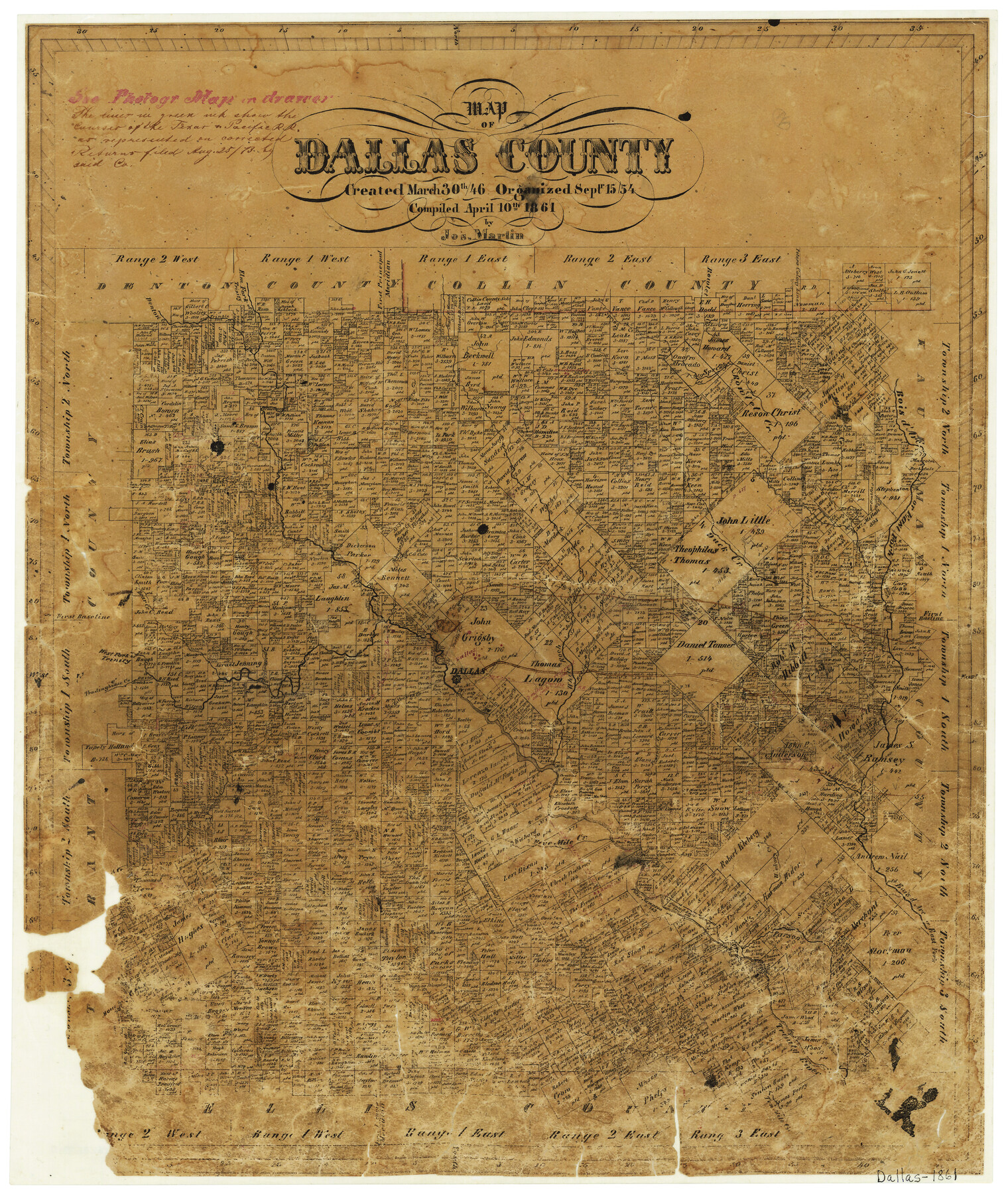
Map of Dallas County
-
Map/Doc
3467
-
Collection
General Map Collection
-
Object Dates
1861/4/10 (Creation Date)
-
People and Organizations
Texas General Land Office (Publisher)
Joseph Martin (Compiler)
-
Counties
Dallas
-
Subjects
County
-
Height x Width
23.5 x 20.0 inches
59.7 x 50.8 cm
-
Comments
Note on map: "Created March 30, 1846; organized September 15, 1854".
Railroads and towns added later to map. -
Features
Tradinghouse Creek
Delaware Creek
Dallas
Mill Creek
White Rock Creek
Redding Creek
Gilbert's Creek
Long Creek
Mesquite Creek
Prairie Creek
Bear Creek
Hickory Creek
Parson's Creek
Five Mile Creek
Ten Mile Creek
Miller
Hutchins
T&P
H&TC
Bois D'Arc Creek
Grapevine Creek
Elm Fork of Trinity River
Trinity River
Farmer's Creek
Larners Creek
Spring Creek
Rowlet Creek
Muddy Creek
Denton Creek
West Fork of Trinity River
North Branch of Trinity River
East Fork of Trinity River
Duck Creek
Ash Creek
Breckenridge
Browning Creek
Hackberry Creek
Part of: General Map Collection
Liberty County Sketch File 2

Print $2.00
- Digital $50.00
Liberty County Sketch File 2
Size 7.7 x 3.3 inches
Map/Doc 29883
Brewster County Working Sketch 64

Print $20.00
- Digital $50.00
Brewster County Working Sketch 64
1957
Size 31.8 x 29.3 inches
Map/Doc 67665
Flight Mission No. CRC-4R, Frame 175, Chambers County

Print $20.00
- Digital $50.00
Flight Mission No. CRC-4R, Frame 175, Chambers County
1956
Size 18.6 x 22.2 inches
Map/Doc 84926
Lampasas County Working Sketch 10

Print $20.00
- Digital $50.00
Lampasas County Working Sketch 10
1963
Size 32.2 x 42.9 inches
Map/Doc 70287
Cherokee County Sketch File 31b

Print $6.00
- Digital $50.00
Cherokee County Sketch File 31b
1934
Size 14.2 x 8.9 inches
Map/Doc 18187
Concho, San Saba & Llano Valley Railway, Sterling City Branch, Texas. Right of Way and Track Map

Print $40.00
- Digital $50.00
Concho, San Saba & Llano Valley Railway, Sterling City Branch, Texas. Right of Way and Track Map
1910
Size 18.3 x 59.7 inches
Map/Doc 64439
Haskell County Sketch File 1A

Print $40.00
- Digital $50.00
Haskell County Sketch File 1A
Size 12.3 x 14.5 inches
Map/Doc 26119
Western United States

Print $20.00
- Digital $50.00
Western United States
1849
Size 18.8 x 27.8 inches
Map/Doc 2088
Boundary Between the United States & Mexico Agreed upon by the Joint Commission under the Treaty of Guadalupe Hidalgo

Print $20.00
- Digital $50.00
Boundary Between the United States & Mexico Agreed upon by the Joint Commission under the Treaty of Guadalupe Hidalgo
1853
Size 18.3 x 26.5 inches
Map/Doc 72886
Flight Mission No. DQO-12K, Frame 37, Galveston County

Print $20.00
- Digital $50.00
Flight Mission No. DQO-12K, Frame 37, Galveston County
1952
Size 18.7 x 22.4 inches
Map/Doc 85228

Young County Sketch File 9

Print $4.00
- Digital $50.00
Young County Sketch File 9
1859
Size 8.5 x 7.8 inches
Map/Doc 40864
You may also like
Map of Capitol Syndicate Subdivisions of Capitol Land Reservation Leagues

Print $40.00
- Digital $50.00
Map of Capitol Syndicate Subdivisions of Capitol Land Reservation Leagues
1906
Size 44.6 x 72.6 inches
Map/Doc 93131
Gillespie County

Print $40.00
- Digital $50.00
Gillespie County
1887
Size 44.1 x 59.7 inches
Map/Doc 16835
Lipscomb County Working Sketch 9

Print $20.00
- Digital $50.00
Lipscomb County Working Sketch 9
1995
Size 44.1 x 22.3 inches
Map/Doc 70585
Jack County Sketch File 13

Print $4.00
- Digital $50.00
Jack County Sketch File 13
Size 10.3 x 8.0 inches
Map/Doc 27537
Medina County Working Sketch 13

Print $20.00
- Digital $50.00
Medina County Working Sketch 13
1972
Size 31.5 x 39.0 inches
Map/Doc 70928
Van Zandt County Sketch File 27

Print $4.00
- Digital $50.00
Van Zandt County Sketch File 27
1859
Size 13.1 x 8.3 inches
Map/Doc 39447
Flight Mission No. CUG-1P, Frame 74, Kleberg County

Print $20.00
- Digital $50.00
Flight Mission No. CUG-1P, Frame 74, Kleberg County
1956
Size 18.5 x 22.3 inches
Map/Doc 86139
Tyler County Sketch File 24

Print $16.00
- Digital $50.00
Tyler County Sketch File 24
1944
Size 11.2 x 9.0 inches
Map/Doc 38681
Bailey County Sketch File 8

Print $6.00
- Digital $50.00
Bailey County Sketch File 8
1913
Size 8.8 x 14.3 inches
Map/Doc 13962
Bandera County Working Sketch Graphic Index

Print $40.00
- Digital $50.00
Bandera County Working Sketch Graphic Index
1947
Size 33.5 x 53.8 inches
Map/Doc 76461
Survey Map of Runnels County

Print $20.00
- Digital $50.00
Survey Map of Runnels County
Size 33.6 x 40.3 inches
Map/Doc 92918
Flight Mission No. DQO-11K, Frame 22, Galveston County

Print $20.00
- Digital $50.00
Flight Mission No. DQO-11K, Frame 22, Galveston County
1952
Size 18.8 x 22.5 inches
Map/Doc 85219