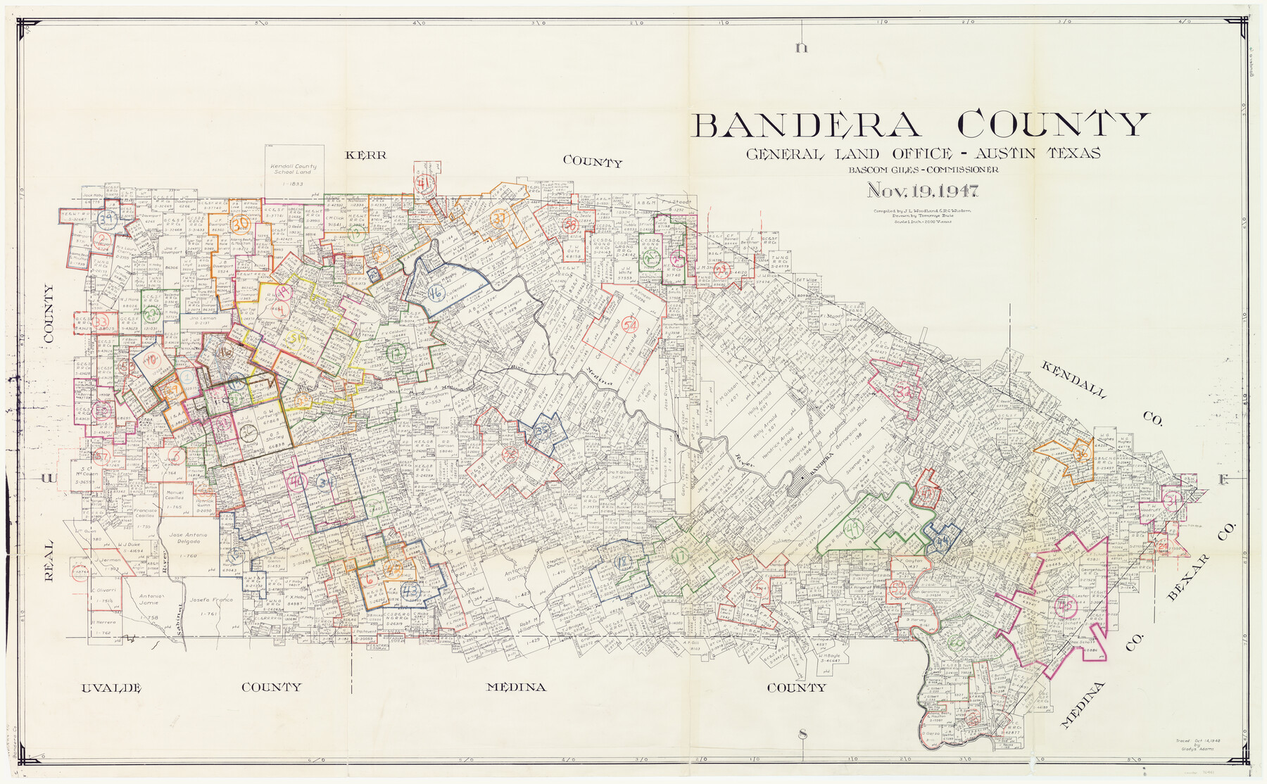
Bandera County Working Sketch Graphic Index
-
Map/Doc
76461
-
Collection
General Map Collection
-
Object Dates
11/19/1947 (Creation Date)
-
People and Organizations
J.L. Woodland (Compiler)
R.C. Wisdom (Compiler)
Tommye Buie (Draftsman)
-
Counties
Bandera
-
Subjects
County Surveying Working Sketch
-
Height x Width
33.5 x 53.8 inches
85.1 x 136.7 cm
-
Scale
1" = 2000 varas
Part of: General Map Collection
Flight Mission No. DCL-6C, Frame 70, Kenedy County

Print $20.00
- Digital $50.00
Flight Mission No. DCL-6C, Frame 70, Kenedy County
1943
Size 18.6 x 22.3 inches
Map/Doc 85912
Houston County

Print $40.00
- Digital $50.00
Houston County
1944
Size 49.3 x 51.0 inches
Map/Doc 76037
Crosby County Working Sketch 14

Print $20.00
- Digital $50.00
Crosby County Working Sketch 14
1976
Size 41.6 x 32.3 inches
Map/Doc 68448

Bell County Sketch File 29

Print $4.00
- Digital $50.00
Bell County Sketch File 29
1874
Size 13.1 x 8.1 inches
Map/Doc 14439
Houston, Capital of Texas, 1837

Print $21.65
Houston, Capital of Texas, 1837
2007
Size 17.4 x 24.3 inches
Map/Doc 89272
San Patricio County Sketch File 28

Print $53.00
San Patricio County Sketch File 28
1935
Size 9.4 x 7.0 inches
Map/Doc 36087
The Rand-McNally New Commercial Atlas Map of Texas

The Rand-McNally New Commercial Atlas Map of Texas
1914
Size 29.4 x 40.7 inches
Map/Doc 88745
Clay County Working Sketch 14

Print $20.00
- Digital $50.00
Clay County Working Sketch 14
1984
Size 46.9 x 34.5 inches
Map/Doc 68037
Armstrong County Working Sketch 7

Print $20.00
- Digital $50.00
Armstrong County Working Sketch 7
Size 18.1 x 16.4 inches
Map/Doc 67238
Rains County Working Sketch 5

Print $20.00
- Digital $50.00
Rains County Working Sketch 5
1950
Size 35.2 x 42.0 inches
Map/Doc 71831
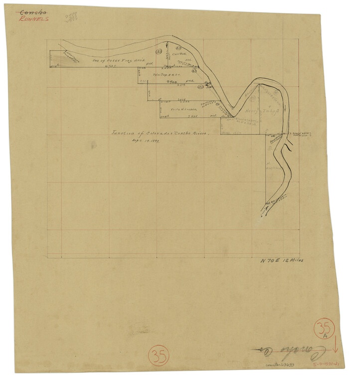
Runnels County Working Sketch 35a
Print $20.00
- Digital $50.00
Runnels County Working Sketch 35a
Size 14.9 x 14.2 inches
Map/Doc 63633
You may also like
Dimmit County Sketch File 14

Print $20.00
- Digital $50.00
Dimmit County Sketch File 14
1884
Size 35.7 x 23.3 inches
Map/Doc 11342
Morris County Rolled Sketch 2A

Print $20.00
- Digital $50.00
Morris County Rolled Sketch 2A
Size 22.5 x 17.6 inches
Map/Doc 10230
Travis County State Real Property Sketch 10

Print $20.00
- Digital $50.00
Travis County State Real Property Sketch 10
2002
Size 35.5 x 25.2 inches
Map/Doc 83550
Clay County Working Sketch 13

Print $20.00
- Digital $50.00
Clay County Working Sketch 13
1955
Size 14.7 x 14.3 inches
Map/Doc 68036
Crockett County Working Sketch 24

Print $20.00
- Digital $50.00
Crockett County Working Sketch 24
1920
Size 43.0 x 17.7 inches
Map/Doc 68357
John B. Slaughter Ranch Situated in Garza County, Texas

Print $20.00
- Digital $50.00
John B. Slaughter Ranch Situated in Garza County, Texas
Size 32.5 x 44.7 inches
Map/Doc 92657
University Lands Blocks 34 to 37, Terrell County, Isogonic Chart & Meridian Changes

Print $20.00
- Digital $50.00
University Lands Blocks 34 to 37, Terrell County, Isogonic Chart & Meridian Changes
Size 23.2 x 22.4 inches
Map/Doc 62940
Fisher County Working Sketch 7

Print $20.00
- Digital $50.00
Fisher County Working Sketch 7
1944
Size 36.7 x 28.9 inches
Map/Doc 69141
Flight Mission No. CUG-1P, Frame 74, Kleberg County

Print $20.00
- Digital $50.00
Flight Mission No. CUG-1P, Frame 74, Kleberg County
1956
Size 18.5 x 22.3 inches
Map/Doc 86139
Map of the County of Cameron, Texas

Print $40.00
- Digital $50.00
Map of the County of Cameron, Texas
1884
Size 54.7 x 34.5 inches
Map/Doc 3141
Hartley County

Print $40.00
- Digital $50.00
Hartley County
1925
Size 41.9 x 52.1 inches
Map/Doc 1851
[Block M-19, and G. & M. Blocks 4 and 5]
![91784, [Block M-19, and G. & M. Blocks 4 and 5], Twichell Survey Records](https://historictexasmaps.com/wmedia_w700/maps/91784-1.tif.jpg)
Print $20.00
- Digital $50.00
[Block M-19, and G. & M. Blocks 4 and 5]
Size 22.4 x 17.7 inches
Map/Doc 91784