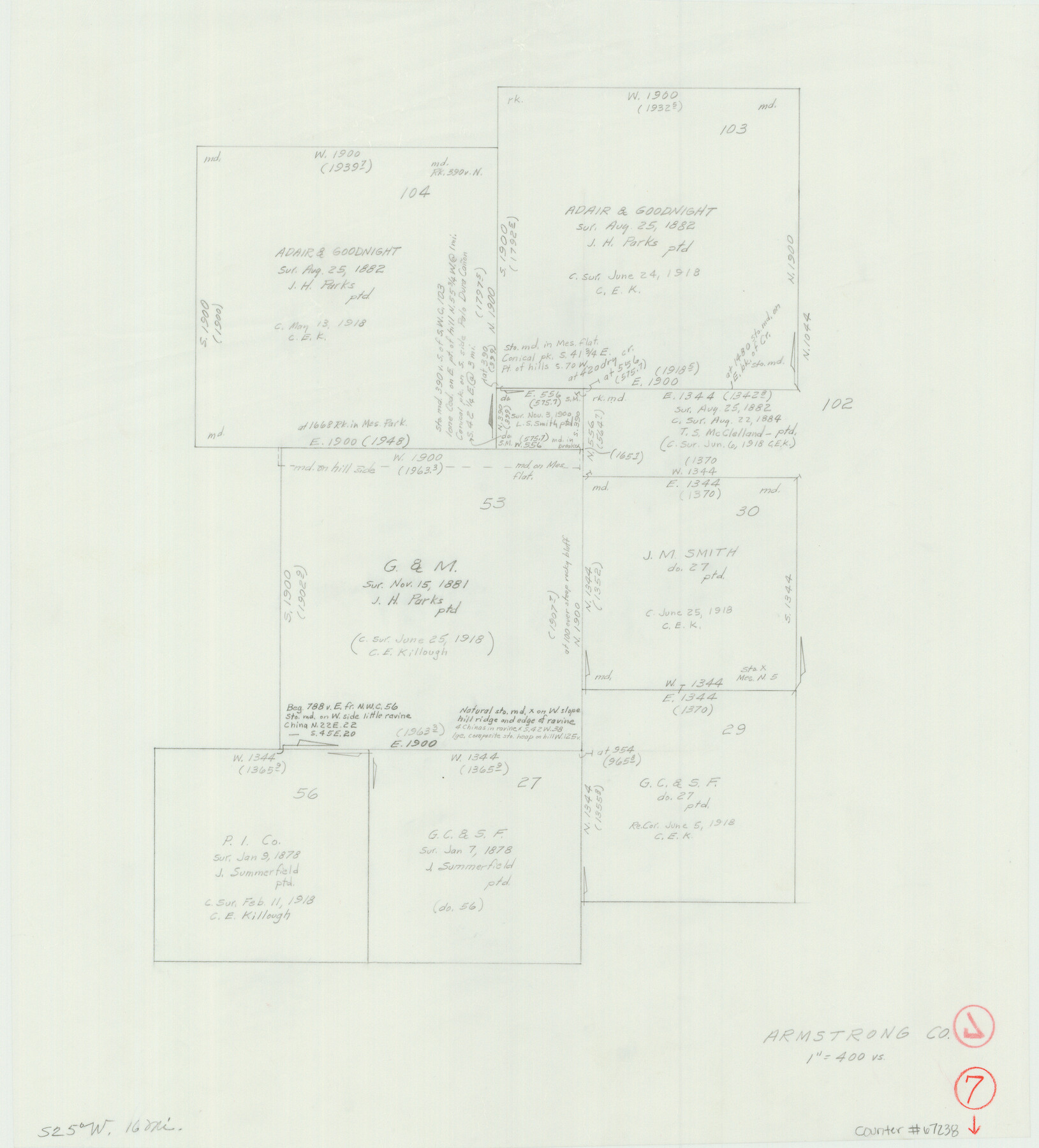
Armstrong County Working Sketch 7
-
Map/Doc
67238
-
Collection
General Map Collection
-
Counties
Armstrong
-
Subjects
Surveying Working Sketch
-
Height x Width
18.1 x 16.4 inches
46.0 x 41.7 cm
-
Scale
1" = 400 varas
-
Comments
Surveys located about 16 miles South 25 degrees West of Claude, Texas.
Part of: General Map Collection
Guadalupe County

Print $20.00
- Digital $50.00
Guadalupe County
1869
Size 27.7 x 22.3 inches
Map/Doc 3607
Shelby County Rolled Sketch 10

Print $20.00
- Digital $50.00
Shelby County Rolled Sketch 10
Size 16.2 x 27.3 inches
Map/Doc 7778
Map of Cooke County originally Fannin Land District

Print $20.00
- Digital $50.00
Map of Cooke County originally Fannin Land District
1858
Size 25.4 x 18.9 inches
Map/Doc 950
Terrell County Sketch File 2-3

Print $38.00
- Digital $50.00
Terrell County Sketch File 2-3
1882
Size 9.1 x 7.7 inches
Map/Doc 37879
Bailey County Sketch File 6

Print $40.00
- Digital $50.00
Bailey County Sketch File 6
Size 26.5 x 31.9 inches
Map/Doc 10884
Ward County Rolled Sketch 15

Print $20.00
- Digital $50.00
Ward County Rolled Sketch 15
1941
Size 26.9 x 39.2 inches
Map/Doc 8158
Uvalde County Working Sketch 41

Print $20.00
- Digital $50.00
Uvalde County Working Sketch 41
1975
Size 15.6 x 27.4 inches
Map/Doc 72111
Real County Working Sketch 55

Print $20.00
- Digital $50.00
Real County Working Sketch 55
1960
Size 21.6 x 35.1 inches
Map/Doc 71947
Edwards County Working Sketch 68

Print $20.00
- Digital $50.00
Edwards County Working Sketch 68
1957
Size 28.7 x 26.8 inches
Map/Doc 68944
Flight Mission No. DIX-6P, Frame 130, Aransas County

Print $20.00
- Digital $50.00
Flight Mission No. DIX-6P, Frame 130, Aransas County
1956
Size 19.3 x 22.9 inches
Map/Doc 83836
Right of Way and Track Map, the Missouri, Kansas and Texas Ry. of Texas - Henrietta Division

Print $20.00
- Digital $50.00
Right of Way and Track Map, the Missouri, Kansas and Texas Ry. of Texas - Henrietta Division
1918
Size 11.8 x 26.8 inches
Map/Doc 64755
Crosby County Sketch File 26

Print $28.00
- Digital $50.00
Crosby County Sketch File 26
1888
Size 14.1 x 8.6 inches
Map/Doc 20098
You may also like
Dimmit County Working Sketch 47

Print $40.00
- Digital $50.00
Dimmit County Working Sketch 47
1980
Size 71.3 x 43.8 inches
Map/Doc 68708
Sketch showing recent surveys of State School Land adjoining Capitol Leagues No. 357 1/2, 367, 373 and 374 corrected out of conflict

Print $2.00
- Digital $50.00
Sketch showing recent surveys of State School Land adjoining Capitol Leagues No. 357 1/2, 367, 373 and 374 corrected out of conflict
1905
Size 7.3 x 10.4 inches
Map/Doc 90535
Cienega Ranch

Print $20.00
- Digital $50.00
Cienega Ranch
1947
Size 17.5 x 17.1 inches
Map/Doc 92287
Zavala County

Print $20.00
- Digital $50.00
Zavala County
1977
Size 36.6 x 41.6 inches
Map/Doc 77468
Williamson County Sketch File 16a

Print $4.00
- Digital $50.00
Williamson County Sketch File 16a
1870
Size 7.0 x 8.4 inches
Map/Doc 40336
Erath County Working Sketch 42

Print $20.00
- Digital $50.00
Erath County Working Sketch 42
1981
Size 23.0 x 23.6 inches
Map/Doc 69123
Hunt County Boundary File 2

Print $6.00
- Digital $50.00
Hunt County Boundary File 2
Size 13.0 x 8.1 inches
Map/Doc 55189
Presidio County Rolled Sketch 105B

Print $20.00
- Digital $50.00
Presidio County Rolled Sketch 105B
Size 46.5 x 36.5 inches
Map/Doc 9789
Midland County Rolled Sketch 14

Print $40.00
- Digital $50.00
Midland County Rolled Sketch 14
Size 102.9 x 43.8 inches
Map/Doc 73579
Sterling County Sketch File 1

Print $40.00
- Digital $50.00
Sterling County Sketch File 1
1862
Size 18.7 x 8.4 inches
Map/Doc 37111
Menard County Boundary File 12a

Print $14.00
- Digital $50.00
Menard County Boundary File 12a
Size 14.2 x 8.8 inches
Map/Doc 57114
Hudspeth County Working Sketch 24

Print $40.00
- Digital $50.00
Hudspeth County Working Sketch 24
1967
Size 46.0 x 54.9 inches
Map/Doc 66306